Georgina River facts for kids
Quick facts for kids Georgina |
|
|---|---|
 |
|
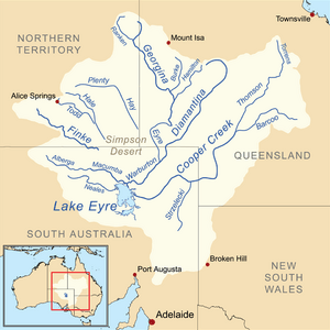
Map of the Lake Eyre Basin showing Georgina River
|
|
| Country | Australia |
| State/territory | Queensland, Northern Territory |
| Region | Central West Queensland, Central Australia |
| City | Boulia |
| Physical characteristics | |
| Main source | Barkly Tableland north of Camooweal |
| River mouth | confluence with the Eyre Creek 97 m (318 ft) |
| Length | 1,130 km (700 mi) |
| Basin features | |
| River system | Lake Eyre basin |
| Basin size | 232,000 km2 (90,000 sq mi) |
| Tributaries |
|
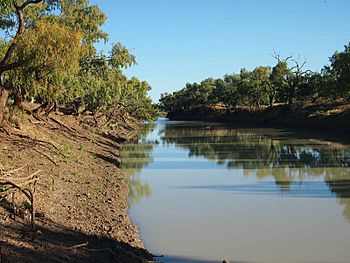
The Georgina River is a big river in Australia. It flows through Central West Queensland and a part of the Northern Territory. It's one of the main rivers in the Channel Country. When there's a lot of rain, the Georgina River flows all the way to Lake Eyre.
The river got its name from Georgina Mildred Kennedy. She was the daughter of Arthur Kennedy, who was a governor of Queensland. Before 1890, it was called the Herbert River. They changed the name to Georgina River to avoid confusion with another river named Herbert in Queensland.
Contents
Where is the Georgina River Located?
The Georgina River starts in the Barkly Tableland. This area is north of Camooweal in Queensland. It also begins in the eastern part of the Northern Territory. Many smaller streams come together to form the Georgina River.
As the river flows south, it joins Eyre Creek. During very wet times, this water eventually reaches the Warburton River. From there, it flows into Lake Eyre.
How Big is the Georgina River's Area?
The area that drains into the Georgina River is huge. It covers about 232,000 square kilometres (90,000 sq mi). This is roughly the same size as the Australian state of Victoria.
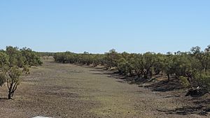
Even though it's so big, the area is very dry. This means the river doesn't always have a lot of water. Some years, there might be almost no water flowing at all. But in very wet years, like 1974, 1977, and 2000, the river can carry a huge amount of water.
What is the Land Like Around the River?
Most of the land around the Georgina River is flat. However, there are some low hills in the northwest. The western part of the river's area has poor soil. This soil isn't good for growing food for cattle or sheep. A large part of this area is an Aboriginal reserve.
The eastern part of the Georgina River area, near Boulia, is different. It has grassy plains with rich, cracking clay soils. These soils are very fertile. They provide excellent food for livestock when it rains. The Lake Machattie Area is also important. Many waterbirds breed there.
What is the Climate Like?
The Georgina River area is drier than some other river basins nearby. The average rainfall is about 400 millimetres (16 in) north of Camooweal. It drops to about 225 millimetres (8.9 in) near Bedourie.
In very dry years, the whole area might get less than 100 millimetres (3.9 in) of rain. But in wet years, like 1974, 1977, and 2000, many places received over 800 millimetres (31 in). Some even got as much as 1,000 millimetres (39 in). Most of this rain falls during the summer months. It's common for no rain to fall from May to September.
Temperatures are usually hot. Most areas have days with temperatures over 30 °C (86 °F) for more than 225 days a year. Frosts are rare, but they can happen. Even in June and July, the highest temperatures are around 25 °C (77 °F).
When Does the Georgina River Flood?
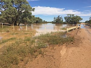
During big floods, the Georgina River can become very wide. In its upper parts, it can be 15 to 20 kilometres (9.3 to 12.4 mi) wide. In the lower parts, it can spread out to 25 to 30 kilometres (16 to 19 mi) wide. These floods can last for months. They can stop roads and trains from moving in the area. The biggest flood ever recorded happened in January 1974.
There was a flood at Glenormiston Station in 1885. Between 12 inches (305 mm) and 17 inches (432 mm) of rain fell in one month. Both the Georgina River and the Diamantina River flooded. Sandringham station was covered in water.
In 1901, the upper parts of the river in the Northern Territory flooded badly. Lake Nash Station got over 10 inches (254 mm) of rain in a single day. The Georgina River reached almost record high levels. In 1953, the river rose over 23 feet (7 m). This was the highest it had been in over 36 years.
The lower parts of the river flooded in 1950 and again in 1953. This happened after heavy rains further north. The 1953 flood was 6 inches (152 mm) higher at Glengyle Station than the 1950 flood. The Diamantina River also flooded, and the waters were expected to reach Lake Eyre.
In 2010, there was moderate flooding along the river. This included Glenormiston Station. It happened after heavy rains in the Georgina River's area.
The Georgina River Bridge at Camooweal
The Barkly Highway is a very important road. It's the only paved road between Queensland and the Northern Territory. For a long time, flooding of the Georgina River near Camooweal was a big problem. The old bridge over the river would often be unusable for days or weeks. Big trucks had to wait until it was safe to cross.
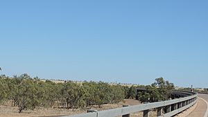
To fix this, a new bridge called the Georgina River Bridge was opened on December 20, 2002. It was opened by Senator Ron Boswell and Steve Bredhauer, who was a minister in the Queensland Government. The new bridge is higher and longer than the old one. This means traffic can keep moving even during floods.
The bridge is 417 metres (1,368 ft) long. It also has a 5.6-kilometre (3.5 mi) new section of highway leading to it. The bridge has a special arch design. This design avoids putting support poles into the riverbed. This is important because the riverbed is a special place for the local Dugalunji people. They call the new bridge Ilaga Thuwani. This means The Camping Ground of the Rainbow Serpent.
See also
 In Spanish: Río Georgina para niños
 | Valerie Thomas |
 | Frederick McKinley Jones |
 | George Edward Alcorn Jr. |
 | Thomas Mensah |


