Barkly Tableland facts for kids
Quick facts for kids Barkly TablelandNorthern Territory |
|||||||||||||||
|---|---|---|---|---|---|---|---|---|---|---|---|---|---|---|---|

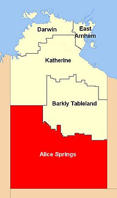
Location of the Barkly Tablelands
|
|||||||||||||||
| Population | 6,330 (2007) | ||||||||||||||
| • Density | 0.0198/km2 (0.051/sq mi) | ||||||||||||||
| Area | 320,000 km2 (123,552.7 sq mi) | ||||||||||||||
| Territory electorate(s) | Barkly | ||||||||||||||
| Federal Division(s) | Lingiari | ||||||||||||||
|
|||||||||||||||
The Barkly Tableland is a huge, flat area of grassland in Australia. It stretches from the eastern part of the Northern Territory into western Queensland. This vast region covers about 283,648 square kilometres. That's about 21% of the entire Northern Territory!
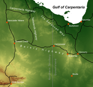
The Barkly Tableland runs alongside the southern coast of the Gulf of Carpentaria. It goes from near Mount Isa, Queensland, to close to Daly Waters.
Contents
History of the Barkly Tableland
Early Explorers and Settlement
William Landsborough was the first non-Indigenous Australian person to explore this tableland. He named it after Sir Henry Barkly, who was the governor of Victoria at the time.
In 1877, Nathaniel Buchanan and Sam Croker rode across the Barkly Tableland. They reached the Overland Telegraph Line. This journey opened up new land for people to settle. The region became more settled when new, easier land leasing rules were introduced in the late 1870s.
Cattle Stations and Famous Figures
In 1883, Harry Readford brought a large group of cattle to the Barkly. He was one of the people who inspired the famous character Captain Starlight. Readford then started Brunette Downs. This huge cattle station had smaller camps, called outstations, at Anthony Lagoon and Cresswell Creek.
In the next few years, thousands more cattle were brought to Brunette Downs. Other large cattle stations in the area include Alexandria, Mittiebah, and Walhallow.
Geography of the Barkly Tableland

The Barkly Tableland rises to more than 300 metres (about 1,000 feet) high. This is especially true near the border between Queensland and the Northern Territory. Much of the tableland is covered by black soil plains.
Climate and Water
This inland area does not get much rain, only about 350mm (14 inches) per year. The rainfall changes a lot with the seasons. Most of the rain falls from November to March during the hot summer. Temperatures can reach up to 40°C (104°F). Winters are cooler, and sometimes there can be frost, especially in the southern parts.
The Barkly Tableland is part of a larger area called the Australian Shield. Water from the tableland flows into different places. Some drains into the Gulf of Carpentaria through the Flinders River. Other parts drain into Lake Eyre or the Simpson Desert.
Waterways on the tableland itself are small. Much of the water sinks into the porous limestone ground. This can sometimes form salt lakes, like Lake Buchanan. Tarrabool Lake, a very large wooded swamp, is also in the west of the tablelands. Important water sources are also artesian springs, which are natural springs where water flows up from deep underground.
Population and Economy
The Barkly region has a small population, with just over 5,900 people. This is the lowest population of any region in the Northern Territory. Most people live in the main town of Tennant Creek.
The economy of Barkly is varied. It includes farming, fishing, and defence. But the main way people earn money is through cattle ranching. The area has some of the best land for raising beef cattle in Australia.
Some of the very large cattle stations on the Tableland include Alexandria Station, Alroy Downs, Anthony Lagoon, Austral Downs, Avon Downs, Banka Banka, Brunette Downs, Creswell Downs, Eva Downs, Helen Springs, Newcastle Waters, and Lake Nash Station.
The region also attracts many visitors, with over 140,000 tourists each year.
Ecology of the Barkly Tableland
Plants of the Grasslands
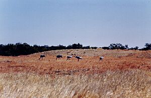
The main type of plant life on the Tableland is a semi-dry savanna made up of Mitchell grass. A savanna is a grassland ecosystem with scattered trees. The Mitchell grass is very tough and has long roots. This helps it survive in dry soils and during droughts.
The Tableland is part of a larger area called the Mitchell Grass Downs ecoregion. An ecoregion is a large area of land or water that contains a distinct group of natural communities and species. This ecoregion stretches for 1500 km southeast into Queensland.
While grasslands are dominant, there are no thick forests here. You'll only find scattered acacia trees and red river gum trees along the waterways.
Animals of the Grasslands
The Mitchell Grass Downs habitat is mostly uniform grassland. Because of this, it doesn't have a huge variety of different animals.
Some mammals found here include the brushtail possum and the Alexandria false antechinus. The antechinus is a small meat-eating marsupial found in only a few places in northern Australia, including Alexandria Station. In Queensland, another endangered marsupial called the Julia Creek dunnart lives in these grasslands.
There are also many grassland birds, like the flock bronzewing. The endangered night parrot has also been seen in Diamantina National Park in Queensland. The seasonal wetlands, like Lake Tarabool swamp, Lake Woods, Lake Buchanan, and Lake Galilee (Queensland), are important places for waterbirds to breed.
Many snakes, reptiles, and amphibians live here. They are adapted to the clay soils that crack in the dry season and turn to mud after the rains. This includes burrowing frogs that come out to breed in the mud. The long-haired rat also appears in huge numbers after the monsoon rains.
Unique reptiles of the downs include the dwarf dtella gecko, some types of skinks, an agamid lizard (Pogona henrylawsoni), and a monitor lizard (Spencer's goanna). Some of the snakes are venomous, such as the speckled brown snake, Ingram's brown snake, and Collett's snake. There are also many unique types of ants.
Threats and Preservation
Some of the grassland is protected, but most of it is used for grazing cattle. While it is mostly unspoiled, it can be harmed by overgrazing. This happens when too many animals eat the grass, especially in areas with Queensland bluebush. The grasslands are home to several endangered species and unique habitats that are at risk.
Protected areas that help preserve the Mitchell grassland include Connells Lagoon Conservation Reserve in the Northern Territory. In Queensland, there's Astrebla Downs National Park, which helps protect the endangered bilby marsupial. Other parks like Moorrinya National Park and Bladensburg National Park are home to the Julia Creek dunnart. Diamantina National Park and White Mountains National Park also protect parts of this important region.
19°38′50″S 134°11′25″E / 19.64722°S 134.19028°E
 | Chris Smalls |
 | Fred Hampton |
 | Ralph Abernathy |


