
Lake Galilee (Queensland) facts for kids
Quick facts for kids Lake Galilee |
|
|---|---|

Lake Galilee
Location in Queensland
|
|
| Location | Galilee, 76 km (47 mi) North East of Aramac, Queensland |
| Coordinates | 22°19′57″S 145°49′23″E / 22.3325°S 145.8230°E |
| Type | Semi-arid, salt lake |
| Catchment area | Cooper Creek catchment |
| Basin countries | Lake Eyre Basin, Australia |
| Max. length | 36 km (22 mi) |
| Max. width | 12.5 km (7.8 mi) |
| Surface area | ~25,700 hectares (64,000 acres) |
| Max. depth | <2 metres (6 ft 7 in) |
| Surface elevation | 279 m (915 ft) |
Lake Galilee is a special salt lake in Central West Queensland, Australia. It's located in a place called Galilee. This lake is quite big, stretching about 36 kilometres long and up to 12.5 kilometres wide. It covers an area of about 25,700 hectares.
Lake Galilee is very important for birds. It's listed as a nationally important wetland. It provides a safe home and a place to breed for many waterbirds. BirdLife International has even named it an Important Bird Area (IBA). This is because it regularly hosts more than 1% of the world's freckled ducks and grey teals. It might also support many other waterbirds and shorebirds.
However, some things threaten the lake. A weed called Parkinsonia is a problem. Wild animals, too much grazing by livestock, and even tourism can harm the lake. Local property owners are working with groups like the Desert Uplands Committee to protect this amazing place.
Contents
Discovering Lake Galilee's Unique Features

Lake Galilee is a unique type of lake in Australia. It's a semi-arid, salty lake formed by movements deep in the Earth's crust. It's located about 76 kilometres north-east of Aramac. The lake is part of the Lake Eyre Basin drainage system.
The lake covers about 25,700 hectares. It's 36 kilometres long and up to 12.5 kilometres wide. The deepest parts are less than two metres deep. The shoreline is very complex with many small bays. There are also three large islands in the southern part of the lake.
The water in the lake changes. When it's full, the water is fresh. But as it dries out, it becomes salty. The northern part of the lake stays fresh for longer. Most rain falls from December to March. In 2010, the area received over 1,000 mm of rain.
Lake Galilee and the smaller Lake Buchanan are rare. They are both tectonic lakes. This means they were formed by Earth's crust moving. They also have small catchments and are bordered by the Great Dividing Range.
Wind has shaped the land around the lake. It has created low dunes called lunettes. The land and plants can be covered or exposed depending on the water level. The lake is most diverse when it's not too full or too empty.
Understanding Wetland Habitats
Semi-arid saline lakes are found in dry areas. They get less than 500 mm of rain each year. Water mainly comes from local creeks. Big rain events bring most of the water. This incoming water is fresh, but it gets salty as the lake dries.
The salt comes from the soil and rocks. Salt levels can be low or high. Some lakes are salty most of the time. But a single lake can have both fresh and salty water. This depends on its shape and where the creeks flow in.
A flat, shallow lakebed in a dry area is called a playa. When dry, playas are cracked clay flats. They might be covered in a thin layer of salt. Some lakebeds have no plants. Others have many different forbs and grasses. These can be good for grazing animals.
When they have water, these lakes can grow many aquatic plants and algae. These are important food sources for animals. This section describes the different habitats of Lake Galilee. It also explains how people are working to protect its amazing biodiversity.
Lake Galilee's Special Habitats
Lake Galilee has six main wetland habitats:
- Dry salty clay flats that flood sometimes.
- Salty flats along the lake's edges with low samphire bushes.
- Sandy beaches around the lake. These have beefwood, other grevilleas, sally wattle, and ironwood trees.
- Red dunes in the southern part of the lake with gidgee woodlands.
- Freshwater swamps behind the dunes with coolabahs.
- Areas of open wattle scrub in the salty flood zone.
Rare and Threatened Ecosystems
Some natural areas are very rare or threatened. They are given a special conservation status. This helps protect them from tree clearing. An area is "endangered" if less than 10% of its original plants remain. Or if 10-30% remains but it's less than 10,000 hectares.
Out of 52 regional ecosystems in the Lake Galilee area, eight are endangered:
- Wetland areas that are mostly water or bare ground.
- Ironwood and beefwood woodlands on lake fringing dunes.
- Gidgee woodlands on lakeside dunes. These are very special to Lake Galilee.
- False sandalwood woodlands on floodplains.
- Brigalow and blackbutt forests or woodlands.
- Blackbutt woodlands on old lake beds.
- Blackbutt woodlands on Mesozoic sediments.
- Brigalow woodlands on Mesozoic sediments.
Another 13 regional ecosystems are considered "Of Concern." This means they also need protection.
A Nationally Important Wetland
| Breeding Colonies | |
| Common name | Scientific name |
|---|---|
| Black swan | Cygnus atratus |
| Australian pelican | Pelicanus conspicillatus |
| Little black cormorant | Phalacrocorax sulcirostris |
| Great egret | Ardea modesta |
| Straw-necked ibis | Threskiornis spinicollis |
| Royal spoonbill | Platalea regia |
| Caspian tern | Hydroprogne caspia |
| Silver gull | Chroicocephalus novaehollandiae |
Lake Galilee is listed on the Directory of Important Wetlands in Australia (DIWA). This list identifies wetlands that are important for the whole country. Lake Galilee meets four of the six criteria for this list.
It's a great example of a seasonal salty lake. It also has seasonal freshwater ponds. It plays a key role in a large wetland system. The lake is an important home for animals at sensitive stages of their lives. It also provides a safe place during droughts. Finally, it supports rare or endangered plants and animals.
Plants of Lake Galilee
Large areas of samphires (Halosarcia spp.) grow around the lake. Samphires are succulent shrubs that can grow up to one metre tall. They often grow in wet, salty areas. They are related to saltbushes.
Samphires have green or reddish-purple stems. They don't have obvious leaves. Their tiny flowers grow in rows. Young samphire plants can be eaten by animals. But older plants collect salt over time.
These plants help trap sediment and nutrients. They also keep the lake edge stable. Samphires can handle tough weather. But they are easily damaged by being walked on.
Other plants found at Lake Galilee include cane grass (Eragrostis australasica). This grass is common in the northern part of the lake. Belalie trees form tall shrublands in some areas.
The weed parkinsonia grows thickly in the south-east inlets. Sesbania thickets are found in the northern lakebed and on southern islands. Dense marshes of ribbed spike-rush (Eleocharis plana) grow with other water plants like Monochoria cyanea and nardoo. Some parts of the lakebed are bare.
Amazing Birdlife at Lake Galilee
| Abundant Waterbirds | |
| Common name | Scientific name |
|---|---|
| Grey teal | Anas gibberifrons |
| Pacific black duck | Anas superciliosa |
| Hardhead | Aythya australis |
| Pink-eared duck | Malacorhynchus membranaceus |
| Australian wood duck | Chenonetta jubata |
| Australasian shoveler | Anas rhynchotis |
| Eurasian coot | Fulica atra |
| Australian pelican | Pelicanus conspicillatus |
| Little black cormorant | Phalacrocorax sulcirostris |
| Great egret | Ardea modesta |
| Australian white ibis | Threskiornis molucca |
| Straw-necked ibis | Threskiornis spinicollis |
| Royal spoonbill | Platalea regia |
| Brolga | Grus rubicunda |
| Sharp-tailed sandpiper | Calidris acuminata |
| Red-kneed dotterel | Erythrogonys cinctus |

Lake Galilee is a rare and important place for waterbirds. It offers a safe home and breeding ground. When water levels are high, huge numbers of birds gather here. These include small birds like grey teal and freckled duck. Larger birds like Australian pelicans and black swans also visit. The number of birds changes with the water levels.
BirdLife Australia recognizes Lake Galilee as an Important Bird Area (IBA). This is because it regularly supports over 1% of the world's population of freckled ducks and grey teals. Sometimes, it also supports over 1% of other waterbirds and shorebirds.
A 2008 bird survey found that two habitats are best for breeding birds. These are the flooded groves of belalie trees and dry islands. The belalie groves had mixed colonies of spoonbills, egrets, ibises, and cormorants. These colonies had hundreds of nests.
The dry islands had colonies of Caspian terns and gulls. They had up to 40 nests. There were also pelican colonies, with the largest having 2,200 breeding pairs.
Migratory Waterbirds' Amazing Journeys
Birds listed as migratory species travel huge distances. They are protected under the Environment Protection Biodiversity Conservation Act 1999 (EPBC Act). These birds fly up to 26,000 kilometres each year. They travel between their breeding grounds in the Northern Hemisphere and their non-breeding areas in the south.
These long trips take several weeks. Birds make short stops along the way to rest and refuel. The path they use is called the East Asian - Australasian Flyway. It stretches from the Arctic Circle, through Asia, to Australia and New Zealand. This is one of eight major waterbird flyways worldwide.

In 1998, a survey counted at least 56,000 waterbirds at Lake Galilee. These birds were in shallow water bodies in the southern part of the lake.
| Resident Shorebirds | |
| Common name | Scientific name |
|---|---|
| Red-capped plover | Charadrius ruficapillus |
| Red-kneed dotterel | Erythrogonys cinctus |
A 2008 survey found five Asian-breeding shorebirds at Lake Galilee. These included godwits, marsh sandpipers, common greenshanks, sharp-tailed sandpipers, and pectoral sandpipers.
The May 2008 survey recorded 50 species and at least 20,000 individual birds. This confirmed Lake Galilee's international importance for waterbirds. The survey also found internationally important numbers of sharp-tailed sandpipers. These were found across four main wetlands in the Desert Uplands.
| Migratory Shorebirds | |
| Common name | Scientific name |
|---|---|
| Black-tailed godwit | Limosa limosa |
| Marsh sandpiper | Tringa stagnatilis |
| Common greenshank | Tringa nebularia |
| Sharp-tailed sandpiper | Calidris acuminata |
| Pectoral sandpiper | Calidris melanotos |
Other Animals at Lake Galilee
Bony bream fish (Nematolosa erebi) live in the lake when the water is not too salty. Frogs appear when the lake is very full.
Small invertebrates, like tiny crustaceans and insects, also live here. These include Ostracods (seed shrimps), Copepods, and Cladocerans (water fleas). Some insects and Molluscs are also found. Their numbers change with the water's saltiness.
Pastoral Settlement History
People started settling on the eastern side of Lake Galilee in 1877. Charles Bowly bought land called Oakley and raised cattle there. He later bought more land, and together they were called "Eastmere" Station.
Charles Bowly later regretted raising cattle. He wrote about the hard work and droughts he faced. He sold his cattle and horses after 21 years. He only had £6000 left, saying "that is Queensland."
| Uncommon Birds | |
| Common name | Scientific name |
|---|---|
| Freckled duck | Sticonetta naevosa |
| Great-crested grebe | Podiceps cristatus |
| Black-tailed godwit | Limosa limosa |
| Pectoral sandpiper | Calidris melanotos |
The new owners of "Eastmere" also found cattle farming difficult. They started raising sheep in 1913. Charles Bowly was lucky to sell when he did. Soon after, a cattle tick disease spread. It killed up to 50% of cattle on some farms. Then, a severe drought hit Queensland from 1899 to 1903. This drought killed 80% of the cattle in the area.
Cattle were brought back in the 1950s. Sheep were removed from "Eastmere" in 1966. Other properties were also established around the lake. These included "Fleetwood," "Lake Dunn," "Clare," and "Clunies Creek."
Farmers started clearing trees in the 1960s. This was done to improve grazing land for cattle. However, a study in the early 2000s raised concerns about too much tree clearing. It noted that 87% of the region was still uncleared in 1999.
Buffel grass was introduced in the late 1960s. Many farmers like it because it helps cattle pastures grow. But it can also harm the environment. It competes with native plants and changes fire patterns.
Buffel grass can take over ecosystems. It forms a dense monoculture, reducing the variety of plants. It also uses up phosphorus and nitrogen from the soil. This can lead to a loss of native plant species over time.
In 1995, a committee was formed to help landholders. They work to improve grazing and protect the environment. They also aim to make farming more profitable and communities stronger.
Threats to Lake Galilee
Lake Galilee faces several threats that can harm its natural environment.
Weeds: A Big Problem

Weeds like Parkinsonia and parthenium are the biggest threats. They can seriously damage this important wetland.
Parkinsonia forms thick, thorny bushes. These block waterbirds from reaching their feeding and resting spots. They also provide shelter for wild pigs. These pigs then disturb the birds' habitats. Parkinsonia is considered one of Australia's worst weeds. It spreads easily and harms both the economy and the environment.
Wetlands are especially vulnerable to parkinsonia. It can invade waterways, cause erosion, and lower water levels. It can also take over large areas of floodplains. At Lake Galilee, it grows easily on the moist edges of the lake.
Parthenium is an annual plant with a deep root. It grows quickly in weak pastures. It also grows in disturbed areas like roadsides and around watering points.
Feral Animals: Wild Pigs Cause Damage
Feral pigs cause a lot of damage to the wetland. They disturb nesting birds and eat frogs and aquatic animals like mussels. They also dig up plants on the lakebed and along the banks. Feral pigs can also carry diseases that affect cattle. This makes controlling them important for farmers and the community.
Grazing Impacts: How Livestock Affect the Lake
In the past, tree clearing and too much grazing happened near the lake. This, along with the introduction of buffel grass, has harmed the lake's biodiversity. It has also affected water quality, erosion, and the makeup of the lakebed.
The lake fringes are very productive. They are often used for grazing, especially after rain. Constant grazing can damage the natural plants and grasses. It can also lead to buffel grass taking over the area.
Recreation and Tourism: Enjoying the Lake Responsibly
More tourists are visiting western Queensland. Many prefer to camp near lakes and waterholes. Visitors sometimes use wood from the area for campfires. This includes hollow branches and logs. Over time, this can destroy habitats for animals that live in hollows. These animals include ducks, parrots, owls, bats, and reptiles.
Human activity can also disturb nesting birds. If birds are disturbed on a hot summer day, their chicks might die. Unleashed pet dogs can also harm ground-nesting waterbirds. They can also disturb wading birds and other ground animals. Some visitors create new vehicle tracks. This can lead to more people using and damaging the area. Other problems include leaving rubbish and not disposing of human waste properly.
Learning More About Lake Galilee
We still need to learn more about Lake Galilee. Like other wetlands in this region, there isn't much ongoing monitoring. Although Lake Galilee was counted in aerial surveys in 1988, 1989, 1993, and 1997, detailed surveys have only happened in 1998 and 2008.
More surveys are needed for the aquatic life in Lake Galilee. These should be done regularly, every five to ten years. This would help us understand the lake's health over time.
Images for kids
-
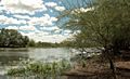
Parkinsonia on the lake's edge
-
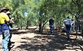
Parkinsonia Field Day at Lake Galilee
-
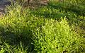
Parthenium weed at Lake Galilee (Queensland)
.jpg)
..jpg)

