Gibson Desert facts for kids
Quick facts for kids Gibson Desert |
|
|---|---|

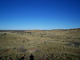
The typical appearance of the Gibson Desert
|
|

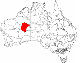
The IBRA-defined boundaries of the Gibson Desert
|
|
| Ecology | |
| Realm | Australasian |
| Biome | deserts and xeric shrublands |
| Borders | Central Ranges xeric scrub, Great Sandy-Tanami desert and Great Victoria Desert |
| Geography | |
| Area | 156,289 km2 (60,344 sq mi) |
| Country | Australia |
| States | Western Australia |
| Conservation | |
| Conservation status | Relatively stable/intact |
| Protected | 91,274 km² (58%) |

The Gibson Desert is a huge desert located in Western Australia. It is still mostly untouched and looks very much like it did a long time ago. This desert covers about 155,000 square kilometers (about 60,000 square miles). This makes it the fifth largest desert in Australia. Only the Great Victoria, Great Sandy, Tanami, and Simpson deserts are bigger. The Gibson Desert is known both as an Australian bioregion and a desert ecoregion.
Contents
Where is the Gibson Desert Located?
The Gibson Desert sits between two salty lakes, Lake Disappointment and Lake Macdonald. It is found along the Tropic of Capricorn. To its south is the Great Sandy Desert, to its east is the Little Sandy Desert, and to its north is the Great Victoria Desert. Some parts of the desert are over 500 meters (1,640 feet) high.
Early explorers, like Ernest Giles, noticed that much of the desert has gravel-covered land. This land is often covered in thin desert grasses. You can also find large areas of rolling red sand plains and sand dunes. There are low, rocky ridges and many uplands with a lot of laterite. Laterite is a type of soil rich in iron. The sandy soil of these buckshot plains is also full of iron.
In the middle of the region, there are a few isolated salt-water lakes. To the southwest, a group of small lakes follows old river paths. The desert gets its underground water from parts of the Officer Basin and Canning Basin.
What is the Climate Like?
The Gibson Desert gets between 200 to 250 millimeters (8 to 10 inches) of rain each year. However, about 3,600 millimeters (140 inches) of water evaporates every year. This means much more water leaves the ground than falls as rain.
The weather is usually hot. In summer, the highest temperatures can go above 40 degrees Celsius (104 degrees Fahrenheit). In winter, the highest temperature might drop to 18 degrees Celsius (64 degrees Fahrenheit). The lowest winter temperatures can be around 6 degrees Celsius (43 degrees Fahrenheit).
How Did the Gibson Desert Get Its Name?
The Gibson Desert was named by an explorer named Ernest Giles. He named it after a member of his team, Alfred Gibson. Alfred Gibson got lost and likely died in this desert during an expedition in 1874.
Who Lives in the Gibson Desert?
In many parts of the Gibson Desert, especially the drier western areas, most of the people living there are Indigenous Australians. These are the native people of Australia.
In 1984, there was a very bad drought. All the water springs dried up, and there was no bush food left. Because of this, a group of Pintupi people, who lived a traditional nomadic life in the desert, walked out of a remote area. This happened in the central-eastern part of the Gibson Desert. They made contact with modern Australian society for the first time. People believe they might have been the last uncontacted tribe in Australia.
On the eastern edge of the desert, there are towns and communities. These include Warburton, Mantamaru, and Warakurna. People of European descent also live in these places. Young Indigenous adults from the Gibson Desert work in programs like Wilurarra Creative. These programs help them keep and develop their culture.
See also
 In Spanish: Desierto de Gibson para niños
 | Delilah Pierce |
 | Gordon Parks |
 | Augusta Savage |
 | Charles Ethan Porter |

