
Alligator Rivers facts for kids
Quick facts for kids Alligator |
|
|---|---|

Location of key Northern Territory uranium mines
|
|

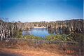
Location of the South Alligator River mouth in the Northern Territory
|
|
| Country | Australia |
| Territory | Northern Territory |
| Physical characteristics | |
| River mouth | Australia 12°14′22″S 132°24′11″E / 12.23944°S 132.40306°E |
The Alligator Rivers is a special area in the Northern Territory of Australia. It gets its name from three main rivers: the East, West, and South Alligator Rivers. When they were first explored, people thought the crocodiles living in the river mouths were alligators, which is how the area got its name!
This region is known for having an amazing variety of plants and animals. Part of it is even inside the famous Kakadu National Park. It's also recognized as an Important Bird Area (IBA) because so many different birds live there. Besides nature, the Alligator Rivers area has important mineral deposits, especially uranium. You can also find over 1500 sites with incredible Australian Aboriginal art. Kakadu National Park is so special that it's a World Heritage Site, meaning it's important for both its natural beauty and its human history.
Contents
The Alligator Rivers

There are three main rivers in this area, each with its own path.
East Alligator River
The East Alligator River is about 160 km (100 mi) long. It starts in the northern part of the Arnhem Land Plateau. From there, it flows northwest through canyons until it reaches the Van Diemen Gulf. This river system covers a huge area of 15,876 km² (6,130 sq mi). It has many smaller streams, called tributaries, that flow into it, like Magela Creek and Cooper Creek. Every year, a massive amount of water, about 6,870 GL (8,980,000,000 cu yd), flows through this river.
South Alligator River
The South Alligator River is also about 160 km (100 mi) long. It begins near Mount Stow, also on the Arnhem Land Plateau. As it flows northwest, it passes through a valley where several old uranium mines used to operate between 1955 and 1965. This river also empties into the Van Diemen Gulf, which is part of the Timor Sea. Its catchment area is 11,917 km² (4,601 sq mi).
West Alligator River
The West Alligator River is shorter, about 80 km (50 mi) long, and starts in the lower lands. Another river, the Wildman River, also flows in this region. The river system is famous for its stunning waterfalls, including the impressive Jim Jim Falls and Twin Falls. Over the last 20,000 years, these rivers have created wide, flat plains, including mangrove swamps, by depositing silt and soil.
Climate and Seasons

The Alligator Rivers region has a monsoon climate, just like many other parts of northern Australia. This means it has two main seasons:
- The dry season lasts from May to September.
- The wet season lasts from November to March.
April and October are in-between times, where the weather changes from one season to the next. The town of Jabiru gets about 1540 mm (61 in) of rain each year, and almost all of it falls during the wet season.
Water Flow and Wildlife
The three Alligator Rivers, and the Wildman River, are perennial rivers. This means they flow all year round, even during the dry season. However, most of their smaller streams and tributaries dry up in places during the dry period. When the land dries out, animals gather around the permanent water sources like the main rivers, springs, waterholes, and billabongs. How long the dry period lasts depends on how much rain fell during the wet season.
During the wet season, the savanna (grasslands) turn green. Animals spread out, and many birds return to the area. The rivers flood the nearby lands, turning them into temporary swamps. As these floodwaters slowly dry up, they leave behind rich silt, which helps the plants grow.
The water temperature is higher during the wet season, and the water is clearer. In the dry season, the water can become cloudier, especially in shallower areas. The Alligator Rivers region can also experience cyclones between October and May, similar to other parts of this Australian region.
Amazing Wildlife

Even though the area is named after alligators (which were actually crocodiles), it's home to a huge variety of plants and animals. More than 1,500 different types of plants have been found here. They grow in many tropical habitats, including mangrove forests, monsoon forests, and grasslands. The river system also has 46 different kinds of fish, which is about a quarter of all known fish species in Australia!
The region is also home to many dusky rats and their main predator, the water python. Scientists are still discovering new animal species here, like the Kakadu dunnart (a small marsupial) and the Kakadu Pebble-mound Mouse. There's an even greater chance of finding new invertebrate species, such as ants.
However, some introduced plants and animals are a threat to the natural ecosystems. Plants like the giant sensitive plant and mission grass are taking over habitats. Invasive species such as feral water buffalo and cane toads are also causing problems for the native wildlife.
Birds of the Alligator Rivers

The Alligator Rivers region is a paradise for birds, with more than one in three of all Australia's bird species seen here. It's especially famous for its many waterbirds, like magpie geese, ducks, herons, ibises, and spoonbills. The floodplains of the Alligator Rivers cover a huge area of 383,000 hectares (about 946,000 acres). It's estimated that about five million waterbirds live here, including over 1% of the world's population of 22 different species. This makes it a truly important place for birds globally.
Aboriginal Culture and History
Aboriginal people have lived continuously in the Alligator Rivers region for an incredible 50,000 years. This long history means the area is full of rich heritage. You can find many ancient cave paintings and rock carvings, with over 1500 sites recorded. Many old Aboriginal tools and items have also been found in ancient camping grounds.
The southern part of Kakadu National Park has several sacred sites linked to Bula, a god connected to creation. These sites are considered very important and powerful by Aboriginal people. You can also find art that shows the first meetings with Makassan traders and early Europeans. For example, at Ubirr Rock, near Cahill's Crossing on the East Alligator River, some paintings are 20,000 years old! They show people throwing spears and wearing headdresses, and also scenes from when Europeans first arrived.
Traditional Owners
The Gagudju people live in the area between the East and South Alligator Rivers. They share the responsibility for managing Kakadu National Park, which is on their traditional land. Gunbalanya (formerly Oenpelli) is an Aboriginal town in the area and is a key center for arts and crafts. The Gagudju language was widely spoken until the early 1900s, but it is not as common today.
The Jawoyn people live in the South Alligator and South Mary regions, as well as around Katherine. In 1993, the Jawoyn made an agreement about the Coronation Hill uranium mine. They allowed more exploration in return for jobs and training for their people, and a partnership in the project.
The Kunwinjku people live between the Liverpool River and the East Alligator River. Traditional beliefs are still very important to the Kunwinjku, with Ngalyod, the Rainbow Serpent, playing a big part in their art and stories. The Kunwinjku have received payments (called royalties) from the Nabarlek Uranium Mine in recent years, as compensation for the use of their land. Many Kunwinjku people live in Gunbalanya and Maningrida.
Modern History and Exploration

Early Explorers
The first English explorer to enter the Gulf of Carpentaria was Phillip Parker King. He explored the area between 1818 and 1822. He named the rivers "Alligator Rivers" because he thought the crocodiles he saw were alligators. His journals mention seeing many large "alligators" and how they seemed too numerous to stop there overnight.
Ludwig Leichhardt was the first European explorer to visit the land in 1845, on his way to Port Essington. He followed a creek from the Arnhem Land escarpment and crossed the South and East Alligator Rivers. John McDouall Stuart also visited the area in 1862.
European Settlement and Mining


European settlement in the Alligator Rivers area was slow because it was very remote, and people often got sick. By the 1880s, people started hunting water buffalo for their hides and horns. Paddy Cahill was the first buffalo hunter in the region and later set up a successful cattle station at Oenpelli by 1906. The buffalo hunting industry lasted about 70 years, until the late 1950s. Crocodile hunting also took place until it became illegal for freshwater crocodiles in 1964 and for estuarine crocodiles in 1971.
Missionaries provided most of the schooling for Aboriginal people for much of the 1900s. A mission was set up near the South Alligator River in 1899, but it only lasted four years. The Church of England Missionary Society started another mission station at Oenpelli in 1925, which ran for 45 years. In 1975, an Aboriginal town council took over running Oenpelli.
Small amounts of gold mining began in the 1920s. However, the discovery of uranium near the South Alligator River in 1953 really kicked off the mining industry. By 1957, there were 13 uranium mines operating, employing 150 people. After large uranium deposits were found at Jabiluka, Ranger, Nabarlek, and Koongarra, the government started an environmental review. This review suggested developing the Ranger site and setting up Jabiru as a support town. Payments, called royalties, are now given to the traditional Aboriginal owners of the land as compensation for the mining activities.
Images for kids
-
Location of key Northern Territory uranium mines
-
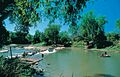
East Alligator River Crossing (Cahills Crossing)
-
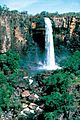
Waterfall - Kakadu National Park after rain.
-
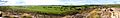
Panorama from Ubirr Rock
-
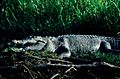
Salt water crocodile - Kakadu National Park
-
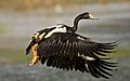
The Alligator Rivers floodplains are of world importance for magpie geese.
-
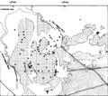
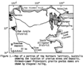
Precambrian geologic map of the Pine Creek Geosyncline: Uranium deposits: R=Ranger, K=Koongarra, N=Nabarlek, and J=Jabiluka.
-
Crocodile Hotel at Jabiru
-
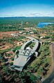
Ranger Uranium Mine viewed from the road
See Also
