Van Diemen Gulf facts for kids
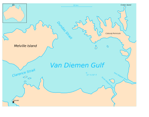
The Van Diemen Gulf (11°49′S 131°57′E / 11.817°S 131.950°E) is a large bay, or gulf, located in northern Australia. It sits between some important land areas. These include Arnhem Land, the Cobourg Peninsula, and Melville Island.
This gulf connects to other big bodies of water. To its west, it links with the Timor Sea. This connection happens through the Clarence Strait. This strait is close to the city of Darwin. To the north, it connects to the Arafura Sea. This northern link is through Dundas Strait. Dundas Strait is found between Melville Island and the Cobourg Peninsula. The Van Diemen Gulf is quite large. It covers an area of about 14,000 square kilometers.
Rivers Flowing into the Gulf
Several rivers flow into the Van Diemen Gulf. These rivers bring fresh water into the gulf. Some of the main rivers include the South Alligator River. The East Alligator River also flows into the gulf. Another important river is the Adelaide River.
How the Gulf Got Its Name
The northern entrance to the Gulf, called Dundas Strait, was first mapped in 1644. This was done by a Dutch explorer named Abel Tasman. The Gulf itself is named after a Dutch leader. He was Anthony Van Diemen. He was the Governor of Batavia at the time.
Protecting the Waters
The waters in the Van Diemen Gulf are very important. Especially the areas near the Cobourg Peninsula. These waters are protected by a special park. It is called the Garig Gunak Barlu National Park. This park helps keep the environment safe. It protects the animals and plants that live there.
See also
 In Spanish: Golfo de Van Diemen para niños
 | Selma Burke |
 | Pauline Powell Burns |
 | Frederick J. Brown |
 | Robert Blackburn |


