
Tirari Desert facts for kids
Quick facts for kids Tirari Desert |
|
|---|---|

NASA satellite image, 2006
|
|

This is a map of the Interim Biogeographic Regionalisation of Australia (IBRA), with state boundaries overlaid. The Tirari Desert region is shown in red.
|
|
| Area | 15,250 km2 (5,890 sq mi) |
| Geography | |
| Country | Australia |
| State | South Australia |
| Region | Far North |
The Tirari Desert is a large desert area in the eastern part of South Australia. It covers about 15,250 square kilometers (5,890 square miles). This desert stretches for about 212 kilometers (132 miles) from north to south and 153 kilometers (95 miles) from east to west.
Contents
Where is the Tirari Desert?

The Tirari Desert has many salt lakes and long sand dunes that run from north to south. It is partly located inside the Kati Thanda-Lake Eyre National Park. Most of the desert is east of Lake Eyre North. A river called Cooper Creek flows right through the middle of the desert.
Other deserts nearby include the Simpson Desert to the north. The Strzelecki Desert is to the east. The Sturt Stony Desert is found to the northeast, along the Birdsville Track. The Tirari Desert has very tough conditions. It gets very hot and receives very little rain. On average, it gets less than 125 millimeters (5 inches) of rain each year.
How to Get There and What You'll Find
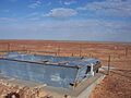
The main way to reach the Tirari Desert by car is using the Birdsville Track. This is an unpaved road that goes north from Marree to Birdsville. The Mungerannie Hotel is the only place between these two towns where you can find services like food and fuel.
The Tirari Desert region is home to several large cattle stations. These stations are also stops for the mail plane that delivers mail to remote areas.
- Dulkaninna Station: This station has been run by the same family for over 110 years. They raise about 2,000 cattle and also breed horses and kelpie dogs.
- Etadunna Station: Located north of Dulkaninna, this is a huge cattle station covering about 4,000 square kilometers (1 million acres). They have about 2,500 cattle. This station has several important historical sites. These include the old Bucaltaninna Homestead ruins, the Woolshed ruins, and Canny Trig Point. The Killalpaninna Mission site, which is listed as a state heritage site, is also nearby.
- Mulka Station: Even further north, Mulka Station also has historical sites. These include old homestead ruins at Apatoongannie, Old Mulka, and Ooroowillannie. The ruins of the Mulka Store are listed on the South Australian Heritage Register.
Plants of the Desert

The sand dunes in the Tirari Desert are mostly covered by two main plants. These are Sandhill Wattle (Acacia ligulata) and Sandhill Cane-grass (Zygochloa paradoxa). These plants grow on the tops and sides of the dunes. You can also find tall, open shrubland on the dune slopes. When it rains, the normally bare sand dunes become covered with a colorful carpet of grasses, herbs, and flowering plants.
The type of soil between the dunes changes depending on how far apart the dunes are. If the dunes are close together, the sandy valleys between them have similar plants to the dune sides. If the dunes are far apart, the areas between them might be stony or flood plains. Each of these areas has its own special group of plants.
The plants on the floodplains also change based on how well the land holds floodwaters and how often it floods. In drier areas, you might see plants like Old Man Saltbush (Atriplex nummularia), Cottonbush (Maireana aphylla), and Queensland Bluebush (Chenopodium auricomum). These form a sparse, open shrubland. In swamps and low areas that flood often, you'll find Swamp Cane-grass (Eragrostis australasica) and Lignum (Muehlenbeckia florulenta).
Along the rivers and permanent waterholes connected to Cooper Creek, you'll find woodlands. These are mostly made up of River Red Gum (Eucalyptus camaldulensis) and Coolibah (Eucalyptus coolabah) trees.
The Tirari Desert is part of a larger area called the Simpson Strzelecki Dunefields (SSD) Region. It is also part of the Tirari–Sturt stony desert ecoregion.
Ancient Fossils
The desert is home to the Lake Ngapakaldi to Lake Palankarinna Fossil Area. This area is about 3.5 square kilometers (1.4 square miles). It is famous for its important Tertiary period vertebrate fossils. These are the remains of animals with backbones that lived millions of years ago.
History of the Tirari Desert

Europeans first explored this area in 1866. Before that, a small group of Aboriginal people called the Tirari lived here.
The Dieri People
The Tirari Desert has been part of the Dieri people's native title claim. This means they have a special connection to the land based on their traditional laws and customs. An Australian expert named Norman Tindale once wrote about a small tribe called the Tirari. He said they lived on the eastern side of Lake Eyre. However, other experts believe these people were part of the Dieri group. Since Tindale's work, we've learned a lot more about Aboriginal language groups.
Early Missions
In the 1860s, two missions for Aboriginal people were started near the Cooper Creek crossing of the Birdsville Track.
- The Moravians built a mission at Lake Kopperamanna in 1866. It didn't last long because of droughts and problems with the local Aboriginal community. It closed in 1869.
- The Bethesda Mission was started by German Lutherans at nearby Lake Killalpaninna around the same time. It was also abandoned for a short period but then reopened. By the 1880s, it looked like a small town with over 20 buildings, including a church. At that time, it had "several hundred aborigines and a dozen whites." The mission mainly made money by raising sheep. It closed in 1917 because of droughts and rabbit plagues. Today, there's not much left of the settlement, just a small cemetery and some old wooden posts. The remains of the mission are listed on the South Australian Heritage Register as the Killalpaninna Mission Site.
European Explorers
In 1866, Peter Egerton Warburton explored the desert to find the northern edge of Lake Eyre. He followed a river he thought was Cooper Creek, but it was actually the Warburton River. In 1874, another expedition led by James William Lewis followed the same river to the Queensland border. On their way back, they went south to the Kopperamanna mission. Then, they followed Cooper Creek to survey the eastern shore of Lake Eyre. Lewis later said about the lake, "I sincerely trust I may never see it again; it is useless in every respect, and the very sight of it creates thirst in man and beast."
Images for kids
-
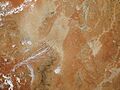
NASA satellite image, 2006
-
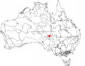
Map of the Tirari Desert region
-
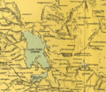
1916 map of Tirari Desert and environs. (Note:the desert is not labelled or delineated)
-
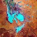
South-west parts of the Tirari Desert, 29 July 1999
-
Tirarai Desert from Southern edge bank of Cooper Creek on Birdsville Track showing old punt for crossing during flood
See also
 In Spanish: Desierto de Tirari para niños
