
Lasseter Highway facts for kids


The Lasseter Highway is an important road in the Northern Territory of Australia. It is a paved road, meaning it's smooth and easy to drive on. This highway stretches for about 244 kilometers (152 miles). It connects the famous natural landmarks of Uluṟu and Kata Tjuṯa, along with the town of Yulara, to the main Stuart Highway.
This road is super important for tourists. It's the main way people travel to visit the amazing Uluṟu-Kata Tjuṯa National Park. The highway gets its name from a prospector named Harold Bell Lasseter. He was a person who searched for valuable minerals. Lasseter claimed he found a huge amount of gold west of Kata Tjuṯa, in a place he called Lasseter's Reef.
About the Lasseter Highway
The Lasseter Highway starts in a place called Erldunda. Erldunda is a roadhouse and hotel. A roadhouse is like a rest stop with fuel, food, and sometimes a place to stay. It's located right on the Stuart Highway. The Stuart Highway is one of Australia's biggest roads. It links Darwin in the north to Adelaide in the south.
Where Does It Go?
From Erldunda, the Lasseter Highway heads west. It runs alongside the southern parts of the Basedow and Kernot Ranges. These are chains of hills or mountains.
- After about 110 kilometers (68 miles), you'll find a turn-off. This is where the Luritja Highway begins. The Luritja Highway goes north towards Kings Canyon.
- About 25 kilometers (15 miles) further southwest, there's a rest area. From here, you can see a great view of Mount Conner.
- Another 22 kilometers (14 miles) down the road is Curtin Springs. This is a large cattle station. A cattle station is a huge farm where cattle are raised. Curtin Springs also has a roadhouse for travelers.
- The highway continues for another 100 kilometers (62 miles) west. This leads you to the tourist town of Yulara.
After Yulara, the Lasseter Highway meets the Great Central Road. This road is a dirt track. It goes into Western Australia and crosses through the Petermann Ranges. It also goes across the huge Gibson and Great Victoria Deserts.
Where to Get Fuel?
It's important to know where to get fuel when traveling. There are petrol stations along the Lasseter Highway.
- You can find a petrol station at Erldunda, right at the start of the highway.
- Another one is at Mount Ebenezer, which is about 57 kilometers (35 miles) into the journey.
- The last one is at Curtin Springs, around 245 kilometers (152 miles) from the start.
Images for kids
-
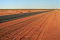
Looking east along the Lasseter Highway toward Erldunda
-
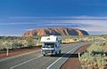
Driving on the Lasseter Highway near the Uluru-Kata Tjuta National Park in the Northern Territory.


