Giles Weather Station facts for kids
Quick facts for kids GilesWestern Australia |
|||||||||
|---|---|---|---|---|---|---|---|---|---|

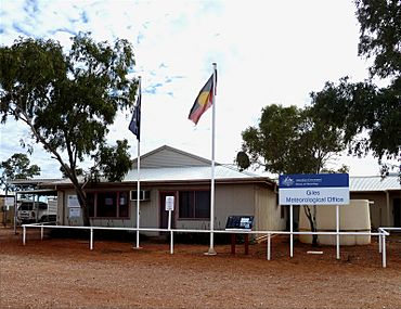
Giles Weather Station in 2011
|
|||||||||
| Population | 3 (2018) | ||||||||
| Established | 1956 | ||||||||
| Postcode(s) | 0872 | ||||||||
| Elevation | 592 m (1,942 ft) | ||||||||
| Time zone | ACST (UTC+9:30) | ||||||||
| • Summer (DST) | ACDT (UTC+10:30) | ||||||||
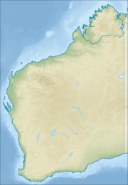
| Location |
|
||||||||
| LGA(s) | Shire of Ngaanyatjarraku | ||||||||
| State electorate(s) | North West Central | ||||||||
| Federal Division(s) | O'Connor | ||||||||
|
|||||||||
| Footnotes | Time zone | ||||||||
The Giles Weather Station is a very important place in Western Australia. It's close to the Northern Territory border. This station is about 750 kilometres (466 miles) west-south-west of Alice Springs. It's also 330 kilometres (205 miles) west of Uluru.
Giles is the only weather station with staff in a huge area. This area is about 2.5 million square kilometres (965,000 square miles)! Its location in the middle of Australia makes it key for predicting weather. It helps forecast rain for eastern and southeastern Australia. The station is on the Great Central Road. The closest town is Warakurna, an Aboriginal settlement. It's just 5 kilometres (3 miles) north of Giles.
Only three people work at this remote station. They stay for four months at a time. The station has its own airport, Giles Airport. It has a 1,600-metre (5,200-foot) long airstrip. This airport also serves the Warakurna community.
Visitors are welcome at Giles. You can watch the daily release of a weather balloon. This happens at 8:45 AM Australian Central Time. There's also a museum to explore. You can see parts of a Blue Streak Rocket and Len Beadell's old road grader there.
Contents
A Look Back: History of Giles Weather Station
How Giles Got Its Name
The Giles Weather Station is named after Ernest Giles. He was an English explorer. He was the first European to travel through this area in 1874.
Building the Station
A surveyor and road builder named Len Beadell chose the spot for the station. This was in December 1955. He worked for a group that researched weapons. The station was needed to help forecast weather. This weather information was important for government testing programs.
Len Beadell also planned and built Giles Airport. He picked the name Giles while building the Gunbarrel Highway. This road connects Carnegie Station to Giles. Beadell's grader, a big machine for building roads, traveled over 30,000 kilometres (18,641 miles)! It stopped working in 1963. Now, it's on display at Giles for everyone to see.
Support for Rocket Testing
Later, the weather station helped with rocket testing. These tests happened at Woomera. Giles was close to the flight path of the rockets. You can see wreckage from the first Blue Streak missile at the station. It was launched from Woomera on June 5, 1964.
Changes Over Time
In the 1960s, the government set up Docker River for local Aboriginal people. It's about 100 kilometres (62 miles) north-east of Giles. Because of too many people there and at Warburton, a new community was needed. This led to the creation of Warakurna in the mid-1970s.
In 1972, the station's control changed. It moved from the Department of Defence to the Bureau of Meteorology. This group is in charge of weather in Australia. In 2018, a TV show reported that Giles would soon be the last weather station on the mainland with permanent staff. Other stations were becoming automated.
Understanding the Climate at Giles
Giles Weather Station has a desert climate. This means it has very hot summers. Rainfall is not regular during these months. Winters are mild and dry.
Sunshine and Rain
Giles gets a lot of sunshine. It has 194 clear days each year. The sun shines for about 3,491 hours annually. Rainfall can change a lot. In 1961, only 38.0 millimetres (1.5 inches) of rain fell. But in 2001, it rained 843.4 millimetres (33.2 inches)!
Heavy rains often happen from November to March. This is when the monsoon trough moves south. Also, old tropical cyclones can bring a lot of rain. Dry periods are common, especially in winter. The longest time without rain was 156 days. This happened from April 18 to September 20, 1961.
| Climate data for Giles Meteorological Office (25º02'S, 123º18'E, 598 m AMSL) (1956-2024 and extremes) | |||||||||||||
|---|---|---|---|---|---|---|---|---|---|---|---|---|---|
| Month | Jan | Feb | Mar | Apr | May | Jun | Jul | Aug | Sep | Oct | Nov | Dec | Year |
| Record high °C (°F) | 45.7 (114.3) |
44.4 (111.9) |
44.6 (112.3) |
38.9 (102.0) |
33.9 (93.0) |
29.9 (85.8) |
30.8 (87.4) |
34.0 (93.2) |
38.2 (100.8) |
41.6 (106.9) |
43.9 (111.0) |
46.8 (116.2) |
46.8 (116.2) |
| Mean daily maximum °C (°F) | 37.3 (99.1) |
36.2 (97.2) |
34.0 (93.2) |
29.5 (85.1) |
23.8 (74.8) |
20.3 (68.5) |
20.3 (68.5) |
22.9 (73.2) |
27.7 (81.9) |
31.9 (89.4) |
34.4 (93.9) |
36.0 (96.8) |
29.5 (85.1) |
| Mean daily minimum °C (°F) | 23.6 (74.5) |
22.8 (73.0) |
20.7 (69.3) |
16.5 (61.7) |
11.3 (52.3) |
8.0 (46.4) |
6.9 (44.4) |
8.8 (47.8) |
13.0 (55.4) |
17.3 (63.1) |
19.9 (67.8) |
22.0 (71.6) |
15.9 (60.6) |
| Record low °C (°F) | 11.7 (53.1) |
9.8 (49.6) |
8.9 (48.0) |
5.4 (41.7) |
1.8 (35.2) |
−1.6 (29.1) |
−2.5 (27.5) |
−1.4 (29.5) |
2.0 (35.6) |
4.2 (39.6) |
7.0 (44.6) |
9.5 (49.1) |
−2.5 (27.5) |
| Average precipitation mm (inches) | 34.7 (1.37) |
43.2 (1.70) |
34.5 (1.36) |
17.6 (0.69) |
20.1 (0.79) |
18.3 (0.72) |
10.2 (0.40) |
9.7 (0.38) |
10.2 (0.40) |
15.9 (0.63) |
29.4 (1.16) |
47.1 (1.85) |
291.5 (11.48) |
| Average precipitation days (≥ 1.0 mm) | 4.1 | 3.8 | 3.1 | 1.9 | 2.3 | 2.0 | 1.4 | 1.2 | 1.5 | 2.3 | 3.4 | 4.7 | 31.7 |
| Average afternoon relative humidity (%) | 21 | 25 | 24 | 24 | 30 | 31 | 29 | 22 | 17 | 16 | 18 | 23 | 23 |
| Average dew point °C (°F) | 7.0 (44.6) |
8.3 (46.9) |
6.1 (43.0) |
3.8 (38.8) |
2.4 (36.3) |
0.8 (33.4) |
−1.3 (29.7) |
−2.8 (27.0) |
−2.7 (27.1) |
−1.2 (29.8) |
2.3 (36.1) |
5.9 (42.6) |
2.4 (36.3) |
| Mean monthly sunshine hours | 313.1 | 271.2 | 288.3 | 273.0 | 263.5 | 249.0 | 279.0 | 306.9 | 306.0 | 325.5 | 309.0 | 306.9 | 3,491.4 |
| Mean daily sunshine hours | 10.1 | 9.6 | 9.3 | 9.1 | 8.5 | 8.3 | 9.0 | 9.9 | 10.2 | 10.5 | 10.3 | 9.9 | 9.6 |
| Source: Bureau of Meteorology | |||||||||||||
 | Misty Copeland |
 | Raven Wilkinson |
 | Debra Austin |
 | Aesha Ash |


