Toad Hop, Indiana facts for kids
Quick facts for kids
Toad Hop, Indiana
|
|
|---|---|

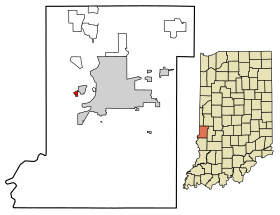
Location of Toad Hop in Vigo County, Indiana.
|
|
| Country | United States |
| State | Indiana |
| County | Vigo |
| Township | Sugar Creek |
| Area | |
| • Total | 0.21 sq mi (0.55 km2) |
| • Land | 0.21 sq mi (0.55 km2) |
| • Water | 0.00 sq mi (0.00 km2) |
| Elevation | 469 ft (143 m) |
| Population
(2020)
|
|
| • Total | 104 |
| • Density | 490.57/sq mi (189.46/km2) |
| Time zone | UTC-5 (Eastern (EST)) |
| • Summer (DST) | UTC-4 (EDT) |
| ZIP code |
47885
|
| Area code(s) | 812, 930 |
| GNIS feature ID | 444789 |
Toad Hop is a small community in Indiana, United States. It is not a full town, but a special kind of place called a census-designated place. This means it has clear borders for counting people.
Toad Hop is located in Vigo County. It is officially considered part of West Terre Haute. Toad Hop is also part of the larger Terre Haute metropolitan area.
Contents
Why is it Called Toad Hop?
The name "Toad Hop" has a fun story behind it. People say that when the area was first being set up, it was a very wet and swampy field. There were many toads and frogs hopping around everywhere! This made people think of the name "Toad Hop."
Where is Toad Hop Located?
Toad Hop is found in Sugar Creek Township. It sits at an elevation of about 469 feet (143 meters) above sea level.
This area is mostly covered with trees. It is located between the I-70 exit for Darwin Road and U.S. Route 40.
How Many People Live in Toad Hop?
| Historical population | |||
|---|---|---|---|
| Census | Pop. | %± | |
| 2010 | 108 | — | |
| 2020 | 104 | −3.7% | |
| U.S. Decennial Census | |||
In 2010, about 108 people lived in Toad Hop. Most of these residents, 107 people, were White. One person was of two or more races. The average age of people living there was 40 years old.
By 2020, the population had slightly decreased to 104 people.
See also
 In Spanish: Toad Hop (Indiana) para niños
 | Roy Wilkins |
 | John Lewis |
 | Linda Carol Brown |

