Tonto Natural Bridge facts for kids
Quick facts for kids Tonto Natural Bridge |
|
|---|---|

Tonto Natural Bridge
|
|
| Location | Gila, Arizona, United States |
| Area | 161 acres (65 ha) |
| Elevation | 4,530 ft (1,380 m) |
| Established | 1969 |
| Visitors | 124,614 (in 2022) |
| Governing body | Arizona State Parks |
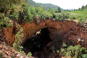
The Tonto Natural Bridge is an amazing natural arch located in Arizona, United States. Many people believe it is the biggest natural bridge made of travertine rock in the entire world!
This special area is now a state park called Tonto Natural Bridge State Park. You can find it off State Route 87, about 10 miles (16 km) north of Payson. The Tonto Natural Bridge stretches over a 400-foot-long (120 m) tunnel. This tunnel is 150 feet (46 m) wide at its broadest point and reaches a height of 183 feet (56 m). It's a truly impressive sight!
Contents
Discovering the Tonto Natural Bridge
A Scotsman named David Gowan was the first person to write about this natural bridge in 1877. He found it while exploring the area and seeking shelter. Gowan was so amazed by the place that he convinced his family to move there from Scotland.
He tried to claim the land for himself, hoping to own it because he was living there. The Gowan family lived near the bridge until 1948. Their old lodge building is still standing today and is a recognized historic place.
In 1948, Glen L. Randall bought the Tonto Natural Bridge and the lodge, along with 160 acres of land. After Randall passed away in 1967, his wife, Eloise Kleinman Randall, sold the property. Eventually, this beautiful natural wonder became a State Park in 1969, so everyone could visit and enjoy it.
Exploring the Park: Trails and Fun
Tonto Natural Bridge State Park offers several ways to explore its beauty. You can walk along different trails and enjoy the amazing views.
- Pine Creek Trail: This trail is about 0.5-mile (0.80 km) long.
- Waterfall Trail: This trail is about 600-foot (180 m) round trip. It leads to a cool waterfall cave.
- Gowan Trail: This trail is also about 0.5-mile (0.80 km) long. It takes you to an observation deck right at the bottom of the creek.
The park also has picnic tables where you can enjoy a meal outdoors. There's a gift shop to find souvenirs and portable restrooms for visitors.
Park Status and Visiting Information
In 2010, the park was planned to close due to budget cuts and to allow for repairs to the historic lodge. However, several groups donated money to keep it open until September 2011. The park then reopened five days a week in 2013.
As of 2025, Tonto Natural Bridge State Park is open and ready for visitors!
Park Hours and Fees
The park is open from 9:00 am to 5:00 pm. Make sure to arrive before 4:00 pm, as that's the last time you can enter.
- Adults: $10.00
- Kids aged 7-13: $5.00
- Children 6 and under: Free
Weather at Tonto Natural Bridge
The climate at Tonto Natural Bridge State Park is known as a hot-summer mediterranean climate. This means it has hot, dry summers and mild, wet winters.
The hottest temperature ever recorded here was 109 °F (42.8 °C) on June 27, 1970. The coldest temperature recorded was 0 °F (−17.8 °C) on January 13, 1963.
| Climate data for Tonto Natural Bridge, Arizona, 1991–2020 normals, extremes 1914–present | |||||||||||||
|---|---|---|---|---|---|---|---|---|---|---|---|---|---|
| Month | Jan | Feb | Mar | Apr | May | Jun | Jul | Aug | Sep | Oct | Nov | Dec | Year |
| Record high °F (°C) | 74 (23) |
80 (27) |
84 (29) |
87 (31) |
97 (36) |
109 (43) |
106 (41) |
102 (39) |
103 (39) |
92 (33) |
83 (28) |
83 (28) |
109 (43) |
| Mean maximum °F (°C) | 64.5 (18.1) |
68.7 (20.4) |
75.7 (24.3) |
82.6 (28.1) |
88.9 (31.6) |
97.2 (36.2) |
98.3 (36.8) |
96.2 (35.7) |
92.2 (33.4) |
84.4 (29.1) |
75.9 (24.4) |
65.7 (18.7) |
99.9 (37.7) |
| Mean daily maximum °F (°C) | 53.9 (12.2) |
57.2 (14.0) |
63.8 (17.7) |
70.4 (21.3) |
78.5 (25.8) |
88.0 (31.1) |
90.7 (32.6) |
88.8 (31.6) |
83.6 (28.7) |
74.4 (23.6) |
63.0 (17.2) |
53.3 (11.8) |
72.1 (22.3) |
| Daily mean °F (°C) | 41.9 (5.5) |
44.6 (7.0) |
49.9 (9.9) |
55.5 (13.1) |
63.0 (17.2) |
72.8 (22.7) |
77.7 (25.4) |
75.4 (24.1) |
70.0 (21.1) |
60.4 (15.8) |
49.6 (9.8) |
41.8 (5.4) |
58.5 (14.8) |
| Mean daily minimum °F (°C) | 30.0 (−1.1) |
31.9 (−0.1) |
35.9 (2.2) |
40.7 (4.8) |
47.6 (8.7) |
57.7 (14.3) |
64.7 (18.2) |
62.1 (16.7) |
56.5 (13.6) |
46.4 (8.0) |
36.3 (2.4) |
30.2 (−1.0) |
45.0 (7.2) |
| Mean minimum °F (°C) | 17.5 (−8.1) |
18.4 (−7.6) |
25.1 (−3.8) |
29.4 (−1.4) |
35.9 (2.2) |
48.6 (9.2) |
56.1 (13.4) |
55.7 (13.2) |
45.7 (7.6) |
32.3 (0.2) |
23.8 (−4.6) |
19.1 (−7.2) |
13.3 (−10.4) |
| Record low °F (°C) | 0 (−18) |
8 (−13) |
8 (−13) |
22 (−6) |
24 (−4) |
36 (2) |
44 (7) |
37 (3) |
31 (−1) |
22 (−6) |
10 (−12) |
4 (−16) |
0 (−18) |
| Average precipitation inches (mm) | 2.94 (75) |
2.79 (71) |
1.94 (49) |
0.80 (20) |
0.59 (15) |
0.28 (7.1) |
2.67 (68) |
2.62 (67) |
1.95 (50) |
1.30 (33) |
1.60 (41) |
2.24 (57) |
21.72 (553.1) |
| Average snowfall inches (cm) | 3.5 (8.9) |
2.1 (5.3) |
2.5 (6.4) |
0.0 (0.0) |
0.0 (0.0) |
0.0 (0.0) |
0.0 (0.0) |
0.0 (0.0) |
0.0 (0.0) |
0.0 (0.0) |
0.5 (1.3) |
2.9 (7.4) |
11.5 (29.3) |
| Average precipitation days (≥ 0.01 in) | 6.8 | 5.4 | 4.5 | 2.6 | 2.6 | 1.6 | 11.8 | 9.3 | 6.3 | 3.1 | 3.0 | 7.8 | 64.8 |
| Average snowy days (≥ 0.1 in) | 1.0 | 0.6 | 0.6 | 0.0 | 0.0 | 0.0 | 0.0 | 0.0 | 0.0 | 0.0 | 0.1 | 0.9 | 3.2 |
| Source 1: NOAA | |||||||||||||
| Source 2: National Weather Service (mean maxima/minima, snow/snow days, precip days 2006–2020) | |||||||||||||


