
Trans-Israel Highway facts for kids
| כביש חוצה ישראל Kvish Ḥotze Yisra'el כביש יצחק רבין Kvish Yitzḥak Rabin |
|
| Cross Israel Highway Yitzhak Rabin Highway |
|
| Lua error in Module:Infobox_road/map at line 15: attempt to index field 'wikibase' (a nil value). | |
Quick facts for kids Route information |
|
|---|---|
| Length | 140 km (90 mi) |
| Major junctions | |
| South end | Ma'ahaz (Ma'ahaz Interchange) |
|
|
| North end | Ein Tut Interchange (Milek stream) |
| Location | |
| Major cities: | Be'er Sheva, Kiryat Gat, Ramla, Petah Tikva, Rosh HaAyin, Pardes Hanna-Karkur, Hadera, Yokne'am, Haifa, |
| Highway system | |
| Roads in Israel Highways |
|

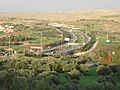
The Trans-Israel Highway, also known as Road 6 or The Israel Turnpike, is a major road in Israel. Its Hebrew name is Hebrew: כביש 6, or Kvish Shesh. It is also called Hebrew: כביש חוצה ישראל, Kvish Chotzeh Yisra'el, which means "Cross Israel Highway." This important highway helps people travel across Israel from the north to the south. The main office for the road is located near Rosh HaAyin, at a place called Kessem Interchange.
Contents
The Trans-Israel Highway: Road 6
Road 6 is one of Israel's most important roads. It helps connect many cities and towns. It makes travel faster and easier for many people. This highway is a "tollway," which means you pay a small fee to use it. The money helps to keep the road in good condition.
What is Road 6?
Road 6 is a long, modern highway. It stretches for about 140 kilometers (87 miles). It is designed to handle a lot of traffic. The highway has many lanes and special exits called interchanges. These interchanges help drivers get on and off the road safely.
Why Was This Highway Built?
The Trans-Israel Highway was built for several reasons. Israel needed a fast and safe way to travel between its northern and southern parts. The highway helps reduce traffic jams on older roads. It also helps connect different parts of the country. This makes it easier for people to live and work in various cities. The highway also helps with the country's economy. It makes it simpler to move goods and services.
How Does Road 6 Work?
Road 6 is a special kind of highway because it uses an electronic toll system. This means you do not stop at toll booths. Instead, sensors read a small device in your car. This makes driving smoother and faster.
Paying for the Ride
When you drive on Road 6, you pay a fee. This fee is called a toll. Most drivers use a special electronic device. This device is called a "Pass." It is placed in your car. When you pass under special gates, the system reads your Pass. The toll is then charged to your account. This system helps traffic keep moving without stopping.
Keeping Things Running Smoothly
There is a special control center for Road 6. This center is located at the Kessem Interchange. Workers at this center watch the highway all the time. They use cameras and sensors to check traffic. They make sure everything is working well. If there is a problem, they can help quickly. This helps keep drivers safe.
Where Does Road 6 Go?
Road 6 connects many important places in Israel. It starts in the south near Ma'ahaz. It then goes north, passing by many major cities. These cities include Be'er Sheva, Kiryat Gat, Ramla, Petah Tikva, Rosh HaAyin, Hadera, and Haifa. The highway ends in the north at the Ein Tut Interchange.
Quick Facts About Road 6
- Road 6 is also known as the Yitzhak Rabin Highway. Yitzhak Rabin was a famous leader in Israel.
- The highway helps reduce travel time between cities.
- It is one of the longest highways in Israel.
- The electronic toll system helps keep traffic flowing smoothly.
Images for kids
-
Kvish Shesh

