Ulong, New South Wales facts for kids
Quick facts for kids UlongNew South Wales |
|
|---|---|

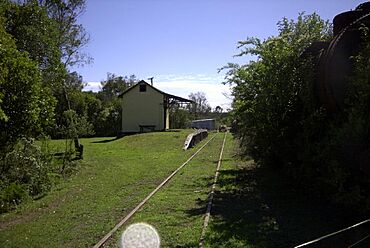
Ulong railway station on the closed Dorrigo railway line
|
|
| Population | 215 (2021 census) |
| Postcode(s) | 2450 |
| LGA(s) | City of Coffs Harbour |
| State electorate(s) | Coffs Harbour |
| Federal Division(s) | Division of Cowper |
Ulong is a small village in New South Wales, Australia. It's located on the Mid North Coast, close to the Northern Tablelands. Even though it's small, Ulong has a community hall, a public school, a cafe that also works as a post office, and a club for veterans.
Contents
Village Life and Services
Ulong has several important places for its community. These include the Ulong Ex-services Club and a cafe. The cafe also acts as a rural transaction centre, which means it helps people with banking and other services.
The Eastern Dorrigo Community Hall is another key spot. It's a place where people can gather. The hall even has camping facilities. These include a kitchen, a BBQ area, and showers for visitors.
Timms Park: A Place to Relax
Timms Park is a lovely picnic area in Ulong. It sits right next to Ulong Creek. The park has tables, bins, and a toilet for everyone to use. The land for this park was kindly given to the community by LEH Timms.
Ulong's Location and Landscape
Ulong is located inland from Coffs Harbour. It's about 36 kilometers away. Even though it's not far, the drive takes about 45 minutes. This is because the road goes through mountainous rainforest.
Ulong is on the Eastern Dorrigo Plateau. It sits about 1700 feet above sea level. The village is known as the "Village in the Valley." Like the nearby village of Lowanna, Ulong has a very different climate from Coffs Harbour.
A Glimpse into Ulong's Past
Ulong was once a very important place. It was even bigger than Coffs Harbour a long time ago! The village was a busy center for the timber industry. Many types of trees were cut down here. These included Dorrigo pine (Araucaria cunninghamii), tallowwood (Eucalyptus microcorys), blackbutt (Eucalyptus pilularis), and coachwood (Ceratopetalum apetalum). The timber was moved using the Dorrigo railway line.
There was also gold found in the hills around Ulong. Georges Gold Mine used to be open for tourists sometimes. However, it closed down in 2007.
Ulong is on the road that leads to the Nymboida River. It's also near two smaller rivers that flow into the Nymboida. These are the Little Nymboida and Bobo Rivers.
Ulong and Motor Sports
In 2007, Ulong hosted a big event. The Australian National series Enduro motorcycle Championships took place there over two days. Later, in 2011, a special part of the World Rally Championship was held in the area. These exciting events use the roads within the many State and National parks nearby. See a picture of morning mists over Ulong
Who Lives in Ulong?
In 2006, Ulong had 131 people living there. By 2016, the population grew to 233 people. The famous Australian actor Jack Thompson calls Ulong home.
Ulong's Weather
The area around Ulong has a special type of weather. It's called a Subtropical highland climate (Cfb). This means summers are warm, humid, and wet. Winters are cool, with frosty nights.
| Climate data for Bobo Nursery | |||||||||||||
|---|---|---|---|---|---|---|---|---|---|---|---|---|---|
| Month | Jan | Feb | Mar | Apr | May | Jun | Jul | Aug | Sep | Oct | Nov | Dec | Year |
| Mean daily maximum °C (°F) | 26.2 (79.2) |
25.7 (78.3) |
24.6 (76.3) |
21.8 (71.2) |
19.1 (66.4) |
17.1 (62.8) |
16.5 (61.7) |
17.5 (63.5) |
20.5 (68.9) |
22.8 (73.0) |
25.1 (77.2) |
26.6 (79.9) |
15.1 (59.2) |
| Mean daily minimum °C (°F) | 15.3 (59.5) |
13.9 (57.0) |
9.4 (48.9) |
5.3 (41.5) |
2.2 (36.0) |
0.6 (33.1) |
2.2 (36.0) |
4.4 (39.9) |
8.7 (47.7) |
11.4 (52.5) |
13.7 (56.7) |
13.7 (56.7) |
8.5 (47.3) |
| Average precipitation mm (inches) | 207.2 (8.16) |
222.0 (8.74) |
258.0 (10.16) |
142.7 (5.62) |
100.1 (3.94) |
110.0 (4.33) |
97.4 (3.83) |
87.5 (3.44) |
66.1 (2.60) |
99.1 (3.90) |
128.4 (5.06) |
169.5 (6.67) |
1,667.6 (65.65) |
| Average precipitation days | 14.5 | 15.3 | 16.3 | 13.2 | 9.0 | 8.1 | 6.5 | 7.1 | 7.8 | 10.7 | 11.4 | 13.5 | 133.4 |
| Average relative humidity (%) | 66 | 69 | 71 | 65 | 66 | 61 | 55 | 53 | 50 | 56 | 60 | 61 | 61 |
 | Roy Wilkins |
 | John Lewis |
 | Linda Carol Brown |


