Vittangi facts for kids
Quick facts for kids
Vittangi
|
|
|---|---|

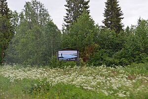
Vittangi welcome sign in July 2015
|
|
| Country | Sweden |
| Province | Lapland |
| County | Norrbotten County |
| Municipality | Kiruna Municipality |
| Area | |
| • Total | 2.27 km2 (0.88 sq mi) |
| Population
(31 December 2010)
|
|
| • Total | 784 |
| • Density | 346/km2 (900/sq mi) |
| Time zone | UTC+1 (CET) |
| • Summer (DST) | UTC+2 (CEST) |
Vittangi is a small village located in Kiruna Municipality, way up north in Norrbotten County, Sweden. In 2010, about 784 people lived here. It's known for its very cold weather and a unique group of people.
The village of Vittangi was started a long time ago in 1674. It was founded by a person named Henrik Mickelsson Kyrö, who came from a place called Pello.
Vittangi is also special because it is home to a group of people who have a rare health condition. This condition means they don't feel pain in the same way most people do.
In February 1985, Vittangi set a record for the coldest month ever in all of Scandinavia. The average temperature that month was a super chilly -27.2 degrees Celsius!
Vittangi's Weather
Vittangi is located in a very northern part of Sweden, which means it has a cold climate. It experiences long, cold winters and short, cool summers. The weather can be quite extreme here!
Temperature Records
- The highest temperature ever recorded in Vittangi was 31.0 degrees Celsius.
- The lowest temperature ever recorded was a freezing -48.7 degrees Celsius. That's colder than most freezers!
Average Temperatures
Even though it can get very cold, the average temperatures change throughout the year:
- In January, the average temperature is around -14.5 degrees Celsius.
- In July, the warmest month, the average temperature is about 14.3 degrees Celsius.
Rain and Snow
Vittangi gets a fair amount of precipitation, especially in the summer months.
- July is usually the wettest month, with about 89.0 mm of rain.
- The winter months, like February and March, are drier, but they get a lot of snow.
| Climate data for Vittangi, 1991-2020 normals and extremes | |||||||||||||
|---|---|---|---|---|---|---|---|---|---|---|---|---|---|
| Month | Jan | Feb | Mar | Apr | May | Jun | Jul | Aug | Sep | Oct | Nov | Dec | Year |
| Record high °C (°F) | 7.7 (45.9) |
8.4 (47.1) |
12.2 (54.0) |
17.6 (63.7) |
28.2 (82.8) |
30.8 (87.4) |
30.4 (86.7) |
29.0 (84.2) |
24.1 (75.4) |
13.5 (56.3) |
8.6 (47.5) |
7.1 (44.8) |
30.8 (87.4) |
| Mean maximum °C (°F) | 1.8 (35.2) |
3.4 (38.1) |
7.1 (44.8) |
11.8 (53.2) |
20.6 (69.1) |
24.8 (76.6) |
26.2 (79.2) |
24.5 (76.1) |
18.7 (65.7) |
10.1 (50.2) |
3.8 (38.8) |
3.1 (37.6) |
27.7 (81.9) |
| Mean daily maximum °C (°F) | −9.3 (15.3) |
−7.8 (18.0) |
−1.5 (29.3) |
4.3 (39.7) |
10.5 (50.9) |
16.8 (62.2) |
19.8 (67.6) |
17.2 (63.0) |
11.3 (52.3) |
2.6 (36.7) |
−4.5 (23.9) |
−7.1 (19.2) |
4.1 (39.4) |
| Daily mean °C (°F) | −14.5 (5.9) |
−13.6 (7.5) |
−7.9 (17.8) |
−0.9 (30.4) |
5.6 (42.1) |
11.4 (52.5) |
14.3 (57.7) |
11.9 (53.4) |
6.4 (43.5) |
−1.0 (30.2) |
−8.5 (16.7) |
−12.1 (10.2) |
−0.7 (30.7) |
| Mean daily minimum °C (°F) | −20.2 (−4.4) |
−19.6 (−3.3) |
−14.8 (5.4) |
−7.1 (19.2) |
−0.1 (31.8) |
5.8 (42.4) |
8.7 (47.7) |
6.5 (43.7) |
1.6 (34.9) |
−4.8 (23.4) |
−12.8 (9.0) |
−17.2 (1.0) |
−6.4 (20.5) |
| Mean minimum °C (°F) | −35.6 (−32.1) |
−34.9 (−30.8) |
−30.4 (−22.7) |
−20.6 (−5.1) |
−7.0 (19.4) |
−0.6 (30.9) |
2.5 (36.5) |
−1.3 (29.7) |
−6.1 (21.0) |
−17.3 (0.9) |
−26.9 (−16.4) |
−31.9 (−25.4) |
−38.0 (−36.4) |
| Record low °C (°F) | −47.0 (−52.6) |
−41.7 (−43.1) |
−39.5 (−39.1) |
−32.3 (−26.1) |
−15.8 (3.6) |
−2.9 (26.8) |
−1.2 (29.8) |
−4.3 (24.3) |
−11.3 (11.7) |
−27.2 (−17.0) |
−36.8 (−34.2) |
−39.8 (−39.6) |
−47.0 (−52.6) |
| Average precipitation mm (inches) | 30.8 (1.21) |
25.3 (1.00) |
22.1 (0.87) |
24.5 (0.96) |
42.0 (1.65) |
65.2 (2.57) |
89.0 (3.50) |
68.5 (2.70) |
51.0 (2.01) |
39.0 (1.54) |
35.3 (1.39) |
34.7 (1.37) |
527.4 (20.77) |
| Source 1: SMHI Open Data | |||||||||||||
| Source 2: SMHI 1991-2020 normals | |||||||||||||
| Climate data for Vittangi, mean 1961-1990, extremes 1961-2011 | |||||||||||||
|---|---|---|---|---|---|---|---|---|---|---|---|---|---|
| Month | Jan | Feb | Mar | Apr | May | Jun | Jul | Aug | Sep | Oct | Nov | Dec | Year |
| Record high °C (°F) | 7.8 (46.0) |
8.4 (47.1) |
12.2 (54.0) |
17.6 (63.7) |
27.7 (81.9) |
30.8 (87.4) |
31.0 (87.8) |
29.0 (84.2) |
23.6 (74.5) |
15.7 (60.3) |
10.2 (50.4) |
7.2 (45.0) |
31.0 (87.8) |
| Mean daily maximum °C (°F) | −11.4 (11.5) |
−9.4 (15.1) |
−2.9 (26.8) |
2.8 (37.0) |
9.9 (49.8) |
16.6 (61.9) |
18.9 (66.0) |
16.0 (60.8) |
10.1 (50.2) |
2.5 (36.5) |
−5.2 (22.6) |
−9.5 (14.9) |
3.2 (37.8) |
| Daily mean °C (°F) | −17.3 (0.9) |
−15.2 (4.6) |
−9.4 (15.1) |
−2.3 (27.9) |
5.0 (41.0) |
11.3 (52.3) |
13.4 (56.1) |
10.9 (51.6) |
5.3 (41.5) |
−1.2 (29.8) |
−9.6 (14.7) |
−15.1 (4.8) |
−2.0 (28.4) |
| Mean daily minimum °C (°F) | −23.7 (−10.7) |
−22.1 (−7.8) |
−17.0 (1.4) |
−8.5 (16.7) |
−0.9 (30.4) |
5.3 (41.5) |
7.3 (45.1) |
5.3 (41.5) |
0.5 (32.9) |
−5.4 (22.3) |
−14.7 (5.5) |
−21.3 (−6.3) |
−7.9 (17.7) |
| Record low °C (°F) | −47.0 (−52.6) |
−48.7 (−55.7) |
−42.4 (−44.3) |
−33.0 (−27.4) |
−16.3 (2.7) |
−5.2 (22.6) |
−3.1 (26.4) |
−5.6 (21.9) |
−14.9 (5.2) |
−29.2 (−20.6) |
−37.1 (−34.8) |
−42.6 (−44.7) |
−48.7 (−55.7) |
 | Mary Eliza Mahoney |
 | Susie King Taylor |
 | Ida Gray |
 | Eliza Ann Grier |


