
Vrbas (river) facts for kids

The Vrbas (Врбас) is an important river located in the western part of Bosnia and Herzegovina. It is one of the biggest rivers that flows into the Sava River. The Vrbas is about 250 kilometers (155 miles) long. Its drainage basin, which is the area of land where all the water flows into the river, covers about 6,273 square kilometers (2,422 square miles). On average, 114 cubic meters of water flow from the Vrbas into the Sava River every second.
Contents
Where the Vrbas River Starts
The Vrbas River begins high up on Ze Mountain, which is part of the Vranica mountain range. It starts from two springs located 1,715 meters (5,627 feet) above sea level. This means it starts very high up in the mountains!
The Vrbas River's Journey
As the Vrbas River flows, it carves out a unique path through different types of land. It passes through several valleys and gorges. These include the Skopljanska valley, the Vinačka gorge, and the Jajce valley. It also flows through the narrow Tijesno canyon and the wider Banja Luka valley. Finally, its lower part flows through the flat Lijevče polja (field) before reaching its end.
Rivers That Join the Vrbas
Many smaller rivers flow into the Vrbas, making it bigger and stronger. These smaller rivers are called tributaries.
- The main rivers that join the Vrbas from its left side are:
- Semešnica
- Pliva
- Black River
- Krupa
- The main rivers that join the Vrbas from its right side are:
- Bistrica
- Ugar
- Svrakava
- Vrbanja river
- Turjanica
The Vrbas River eventually flows into the Sava River near a town called Bosanska Gradiška.
Images for kids
-
-
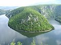
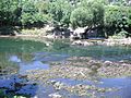
The river


See also
 In Spanish: Río Vrbas para niños
