Wacousta, Michigan facts for kids
Quick facts for kids
Wacousta, Michigan
|
|
|---|---|

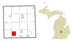
Location within Clinton County
|
|
| Country | United States |
| State | Michigan |
| County | Clinton |
| Township | Watertown |
| Area | |
| • Total | 8.99 sq mi (23.29 km2) |
| • Land | 8.91 sq mi (23.09 km2) |
| • Water | 0.08 sq mi (0.20 km2) |
| Elevation | 824 ft (251 m) |
| Population
(2020)
|
|
| • Total | 1,532 |
| • Density | 171.85/sq mi (66.35/km2) |
| Time zone | UTC-5 (Eastern (EST)) |
| • Summer (DST) | UTC-4 (EDT) |
| ZIP code(s) | |
| Area code(s) | 517 |
| FIPS code | 26-82680 |
| GNIS feature ID | 2583768 |
Wacousta is a small community in Clinton County, Michigan, in the United States. It's known as an unincorporated community and a census-designated place (CDP). This means it's a recognized area with its own population numbers, but it doesn't have its own city government.
Wacousta is located within Watertown Charter Township. In 2010, about 1,440 people lived there. By 2020, the population had grown to 1,532.
Contents
What is a Census-Designated Place?
A census-designated place, or CDP, is a special area defined by the United States Census Bureau. These places are like towns or communities that don't have their own official city or town government. However, the Census Bureau gives them boundaries and collects population data for them.
This helps gather information about how many people live in different areas. It also helps us understand where people are located, even if they are not in a formally organized city.
Where is Wacousta Located?
Wacousta is found in Clinton County, which is in the state of Michigan. It's part of Watertown Charter Township.
How Big is Wacousta?
The total area of Wacousta is about 8.99 square miles (23.29 square kilometers). Most of this area is land, about 8.91 square miles (23.09 square kilometers). A small part, about 0.08 square miles (0.20 square kilometers), is water.
The Looking Glass River
The Looking Glass River flows right through Wacousta. It moves from the east side of the community to the west side. Rivers like this are important for the local environment and can be a place for outdoor activities.
How Many People Live in Wacousta?
The population of Wacousta has been counted during the U.S. Census.
- In 2010, the population was 1,440 people.
- By 2020, the population had increased to 1,532 people.
This shows that more people are choosing to live in Wacousta over time.
Images for kids
See also

- In Spanish: Wacousta para niños


