Waialua, Hawaii facts for kids
Quick facts for kids
Waialua
|
|
|---|---|

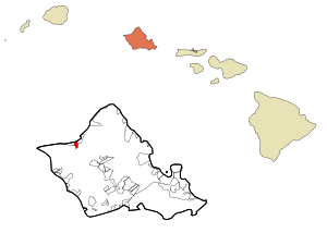
Location in Honolulu County and the state of Hawaii
|
|
| Country | United States |
| State | Hawaii |
| Area | |
| • Total | 2.39 sq mi (6.19 km2) |
| • Land | 2.19 sq mi (5.68 km2) |
| • Water | 0.20 sq mi (0.51 km2) |
| Elevation | 13 ft (4 m) |
| Population
(2020)
|
|
| • Total | 4,062 |
| • Density | 1,853.95/sq mi (715.75/km2) |
| Time zone | UTC-10 (Hawaii-Aleutian) |
| ZIP code |
96791
|
| Area code(s) | 808 |
| FIPS code | 15-74000 |
| GNIS feature ID | 0364543 |
Waialua (Hawaiian pronunciation: [vɐjəˈluwə]) is a community on the North Shore of Oʻahu island in Hawaii. It is located in Honolulu County, United States. In 2020, about 4,062 people lived there.
Waialua was one of the six original areas of ancient Hawaii on the island. It was known as a moku. Today, Waialua is a quiet town that used to be a sugar mill center. It's different from nearby Haleʻiwa, which is busier with shops and tourists. The Waialua Sugar Mill is a key part of the town's history.
The U.S. postal code for Waialua is 96791.
Contents
Exploring Waialua's Location
Waialua is found at 21°34'31" north and 158°7'46" west. It is southwest of Haleʻiwa. You can reach it by Waialua Beach Road (State Rte. 82) or Kaukonahua Road (State Rte. 830).
Kaukonahua Road goes east and then becomes State Rte. 803 and 801. These roads lead up to the middle part of Oʻahu, to places like Wahiawā or Schofield Barracks. Farrington Highway (State Rte. 930) goes west to Mokulēʻia.
The United States Census Bureau says that Waialua covers about 2.39 square miles (6.2 square kilometers). Most of this area, about 2.19 square miles (5.7 square kilometers), is land. The rest, about 0.20 square miles (0.5 square kilometers), is water.
Waialua's Population and People
| Historical population | |||
|---|---|---|---|
| Census | Pop. | %± | |
| 2020 | 4,062 | — | |
| U.S. Decennial Census | |||
In the year 2000, there were 3,761 people living in Waialua. These people lived in 1,128 households, and 882 of these were families. The population was spread out, with many different groups of people.
About 15.34% of the people were White, and 51.85% were Asian. About 3.96% were Pacific Islander, and 27.39% were from two or more races. Also, 6.54% of the people were Hispanic or Latino.
About 29.3% of households had children under 18 living with them. The average household had about 3.31 people. The average family had about 3.71 people.
The median age in Waialua was 39 years old. This means half the people were younger than 39, and half were older. About 23.9% of the population was under 18. About 18.9% of the people were 65 years or older.
Schools and Libraries in Waialua
The Hawaii Department of Education runs the public schools in Waialua. These include Waialua Elementary School and Waialua High & Intermediate School.
There is also a private school called St. Michael School. It is run by the Roman Catholic Diocese of Honolulu and teaches students from kindergarten to 8th grade.
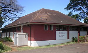
For reading and learning, the Hawaii State Public Library System operates the Waialua Library.
Waialua's Rich History
Many families living in Waialua today are connected to the farming industry that started in the early 1900s. As this industry grew, more workers were needed. People came from many places like China, Portugal, Japan, Korea, Puerto Rico, and the Philippines.
When they arrived in Hawaii, many of these workers were sent to work on the sugarcane plantations in Waialua. In the late 1980s and 1990s, sugar production slowed down. This was because it became too expensive to grow and process sugar in Hawaii. Many companies moved their operations overseas.
Even though the sugar industry changed, many families who came to Waialua for the sugar rush stayed. Their descendants still live there today.
During World War II, large guns from the ship USS Saratoga were placed near Waialua. These guns were used as part of the defenses for the area.
See also
 In Spanish: Waialua para niños
 | Laphonza Butler |
 | Daisy Bates |
 | Elizabeth Piper Ensley |


