
Wahiawa, Hawaii facts for kids
Quick facts for kids
Wahiawa
Wahiawā
|
|
|---|---|

Location in Honolulu County and the state of Hawaii
|
|
| Country | United States |
| State | Hawaii |
| Area | |
| • Total | 2.54 sq mi (6.58 km2) |
| • Land | 2.29 sq mi (5.93 km2) |
| • Water | 0.25 sq mi (0.65 km2) |
| Elevation | 942 ft (287 m) |
| Population
(2020)
|
|
| • Total | 18,658 |
| • Density | 8,151.16/sq mi (3,146.91/km2) |
| Time zone | UTC-10 (Hawaii-Aleutian) |
| ZIP code |
96786
|
| Area code(s) | 808 |
| FIPS code | 15-72650 |
| GNIS feature ID | 0364420 |
Wahiawa (which means "place of the wa people" in Hawaiian) is a town located in Honolulu County, Hawaii. It's on the island of Oahu, right in the middle, on a flat area between two big volcanic mountains. In 2020, about 18,658 people lived there.
Wahiawa is special because it's mostly surrounded by a large body of water called Lake Wilson. This lake is also known as Wahiawā Reservoir. To get into town, you usually have to cross one of two bridges over the lake. Around Wahiawa, you'll find military bases and farms, though more buildings are being built. Important military places like Schofield Barracks and Wheeler Army Airfield are nearby. The United States Navy also has a big communication center here.
The main mail codes (ZIP codes) for Wahiawa are 96786 and 96857.
Contents
Wahiawa's Location and Surroundings
Wahiawa is found at coordinates 21.502574 degrees North and -158.022938 degrees West.
To travel to the North Shore from Wahiawa, you can take Kamehameha Highway (State Route 80) to Haleʻiwa. Another road, Kaukonahua Road (State Route 801), leads to Waialua.
Military bases like Wheeler and Schofield are reached by Wilikina Drive (State Route 99). This road goes around Wahiawa from the south bridge. It connects to other main roads northwest of town. Kamehameha Highway also goes south past Wheeler to Mililani Town.
A major highway, Interstate H-2, ends near Wahiawa. It's a good way to travel south to places like Pearl City and Honolulu using Interstate H-1. Kunia Road (State Route 750) also starts near Wahiawa. It goes south through farmland to Kunia and Waipahu.
The town covers about 2.54 square miles (6.58 square kilometers). Most of this area is land, but about 0.25 square miles (0.65 square kilometers) is water.
Kaʻala, the highest point on Oahu, is about 5 miles (8 kilometers) west of Wahiawa. It stands tall at 4,003 feet (1,220 meters).
Lake Wilson, also called Wahiawā Reservoir, is the second-largest reservoir in Hawaii. It covers about 302 acres (1.22 square kilometers). This lake helps water the pineapple fields of the Dole Pineapple Plantation. The water from the lake eventually flows to Oahu's North Shore.
Wahiawa's Population
In 2020, Wahiawa had a population of 18,658 people.
Back in 2000, there were 16,151 people living here. There were 5,376 homes, with many families. The town is home to people from many different backgrounds. About 11% of the people were of Hispanic or Latino heritage.
The average household in Wahiawa had about 3 people. Many homes had children under 18 living there.
Schools in Wahiawa
Public Schools
The Hawaiʻi State Department of Education runs the public schools in Wahiawa.
- Elementary Schools: ʻIliahi, Kaʻala, and Wahiawā Elementary Schools are in the town.
- Middle School: Wahiawā Middle School is very close to Wahiawa.
- High School: Leilehua High School is located right in Wahiawa.
Some other schools have a Wahiawa mailing address but are in nearby areas. These include:
- Samuel K. Solomon Elementary School and Daniel K. Inouye Elementary School (formerly Hale Kula) in Schofield Barracks.
- Helemano Elementary School in Whitmore Village.
- Major Sheldon Wheeler Elementary School and Major Sheldon Wheeler Middle School at Wheeler Army Airfield.
Private Schools
Wahiawa also has several private schools:
- Trinity Lutheran Church and School (Lutheran)
- First Baptist Church
- Hoʻala School
- Abundant Life United Pent Church
- Maranatha Christian Academy
- Hawaii Matsuritaiko
Bridges in Wahiawa
Wahiawa has a few important bridges:
- Karsten Thot Bridge (built in 1932)
- Kaukonahua Bridge (built in 1944)
- Wilson Bridge
Famous People from Wahiawa
Many interesting people have come from Wahiawa:
- Al Harris, a professional football player
- Betty Ann Bruno, a child actor and journalist
- Martin Iosefo, a professional rugby player for the U.S. national team
- Lia Marie Johnson, an actress, singer, and YouTube star
- Adrian Murrell, a professional football player
- Netane Muti, a professional football player
- Kealoha Pilares, a professional football player
- Lauvale Sape, a professional football player
- Antonio Taguba, a military general
- Charles Tuaau, a professional football player
- Suzanne Vares-Lum, president of the East-West Center
- Tadashi Wakabayashi, a professional baseball player
- Corinne Watanabe, a judge
Gallery
-
Dole Food Company started in Wahiawā in 1851.
-
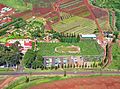
Dole's Plantation Garden Maze was the world's largest maze in 2008. It covers a huge area of 137,194 square feet!
-
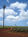
This pineapple field in Wahiawā is where the Dole pineapple business began.
-

Wahiawā is home to the 25th I.D. Tropic Lightning, which has been here since 1941. More than 15,000 soldiers are based at Schofield Barracks.
-
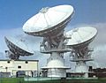
These are Navy satellite antennas in Wahiawā.
-
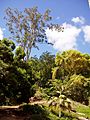
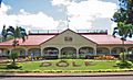
The Wahiawa Botanical Garden is a popular place to visit in Wahiawā.
-
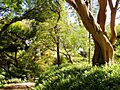
Another view of the beautiful Wahiawā Botanical Garden.


See also
 In Spanish: Wahiawa para niños
