
Interstate H-2 facts for kids
Quick facts for kids
|
||||
|---|---|---|---|---|
| Veterans' Memorial Freeway | ||||
| Lua error in Module:Infobox_road/map at line 15: attempt to index field 'wikibase' (a nil value). | ||||
| Route information | ||||
| Maintained by HDOT | ||||
| Length | 8.33 mi (13.41 km) | |||
| Existed | 1976/1977–present | |||
| Major junctions | ||||
| South end | ||||
| North end | ||||
| Highway system | ||||
| Main route of the Interstate Highway System Main • Auxiliary • Business Routes in Hawaii
|
||||

Interstate H-2 (often called H-2) is a special highway on the island of O‘ahu in Hawai‘i, USA. It is part of the Interstate Highway System. Even though it's called an "Interstate," H-2 stays completely within Hawai‘i. It is also known as the Veterans Memorial Freeway. This highway helps people travel between Pearl City and Wahiawā.
Exploring Interstate H-2
Interstate H-2 is about 8.33 miles (13.41 kilometers) long. It connects important places on O‘ahu.
Where Does H-2 Go?
This highway runs from south to north. The southern end of H-2 connects to Interstate H-1 in Pearl City. Its northern end is at Wilikina Drive, which is also Route 99, in Wahiawā. This area is near Schofield Barracks and Wheeler Army Airfield.
Why Is It Called H-2?
You might think that "Interstate H-2" sounds like it should go east-west. This is because most interstate highways with even numbers usually run east-west. However, H-2 actually runs north-south. The "H" in its name stands for Hawai‘i. The number "2" simply shows the order in which these special Hawaiian interstates were planned and built. H-1 was first, then H-2, and so on.
Images for kids
-
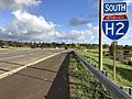
H-2 southbound in Wahiawā
_just_south_of_Exit_9_(Hawaii_State_Route_99)_in_Wahiaw%C4%81,_Oahu,_Hawaii.jpg)
See also
 In Spanish: Interestatal H-2 para niños
