Kaʻala facts for kids
Quick facts for kids Kaʻala |
|
|---|---|

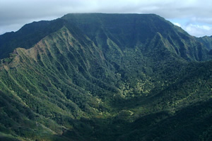
Plateau at the summit of Mount Kaʻala
|
|
| Highest point | |
| Elevation | 4,025 ft (1,227 m) |
| Prominence | 4,025 ft (1,227 m) |
| Naming | |
| Language of name | Hawaiian |
| Geography | |
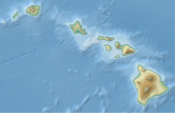
| Location | Oahu, Hawaii, US |
| Parent range | Waianae Range |
| Topo map | USGS Haleiwa |
| Geology | |
| Age of rock | 3.9 Ma |
| Mountain type | Plateau |
| Volcanic arc/belt | Hawaiian-Emperor seamount chain |
Kaʻala or Mount Kaʻala is the highest mountain on the island of Oahu in Hawaii. It stands tall at about 4,025 feet (1,227 meters) above sea level. This impressive peak is part of the Waiʻanae Range, which is a very old shield volcano located on the western side of Oahu.
What is a Shield Volcano?
A shield volcano is a type of volcano that looks like a warrior's shield lying on the ground. It has gentle slopes and is built up over time by many layers of fluid lava flows. Kaʻala was formed about 3.9 million years ago from such lava flows. Over a very long time, parts of this ancient volcano have been worn away by weather and erosion.
Location and Importance
Mount Kaʻala is found on the island of Oahu, which is one of the main islands of Hawaii. Its high elevation makes it a very important landmark. The mountain is part of the Hawaiian–Emperor seamount chain, a long line of volcanoes and underwater mountains that stretch across the Pacific Ocean.
What's at the Top?
The very top of Mount Kaʻala is home to an important facility. The FAA (which manages air traffic) has an active tracking station there. This station helps keep track of airplanes flying in the area.
The summit area is not open to the public. It is secured by the United States Army, which has a base called Schofield Barracks at the foot of the mountain. You can often see the tracking station from far away because it looks like a white dome.
See also
 In Spanish: Ka'ala para niños
 | Percy Lavon Julian |
 | Katherine Johnson |
 | George Washington Carver |
 | Annie Easley |


