Wall Lane, Arizona facts for kids
Quick facts for kids
Wall Lane, Arizona
|
|
|---|---|

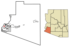
Location of Wall Lane in Yuma County, Arizona.
|
|
| Country | United States |
| State | Arizona |
| County | Yuma |
| Area | |
| • Total | 0.44 sq mi (1.13 km2) |
| • Land | 0.44 sq mi (1.13 km2) |
| • Water | 0.00 sq mi (0.00 km2) |
| Elevation | 112 ft (34 m) |
| Population
(2020)
|
|
| • Total | 262 |
| • Density | 599.54/sq mi (231.68/km2) |
| Time zone | UTC-7 (Mountain (MST)) |
| ZIP code |
85365
|
| Area code(s) | 928 |
| GNIS feature ID | 2582895 |
Wall Lane is a small community in Yuma County, Arizona. It is known as a census-designated place, or CDP. This means it's an area that the U.S. Census Bureau defines for collecting population data. It is also a type of community called a colonia. In 2020, about 262 people lived in Wall Lane.
Where is Wall Lane Located?
Wall Lane is found in the state of Arizona, in the United States. It is part of Yuma County. The community covers a total area of about 0.44 square miles. All of this area is land, with no water.
How Many People Live in Wall Lane?
The number of people living in Wall Lane is counted by the U.S. Census Bureau. This count happens every ten years. In 2010, the population was 415 people. By the year 2020, the population had changed to 262 people.
| Historical population | |||
|---|---|---|---|
| Census | Pop. | %± | |
| 2020 | 262 | — | |
| U.S. Decennial Census | |||
See also
 In Spanish: Wall Lane para niños

All content from Kiddle encyclopedia articles (including the article images and facts) can be freely used under Attribution-ShareAlike license, unless stated otherwise. Cite this article:
Wall Lane, Arizona Facts for Kids. Kiddle Encyclopedia.

