Waterden medieval settlement facts for kids
Quick facts for kids Waterden medieval settlement |
|
|---|---|

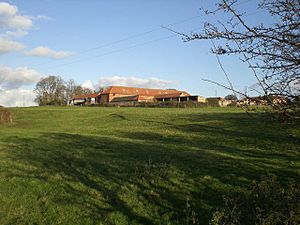
Looking north-east across the site, towards Waterden Farm
|
|
| Location | Norfolk |
| OS grid reference | TF 887 363 |
| Designated | 17 August 1976 |
| Reference no. | 1018174 |
| Lua error in Module:Location_map at line 420: attempt to index field 'wikibase' (a nil value). | |
The Waterden medieval settlement is a fascinating historical site in Norfolk, England. It's what we call a deserted medieval village, which means it was once a busy village during the Middle Ages but is now empty. You can find it about 3 miles (4.8 km) west of a town called Walsingham. This special place is protected as a Scheduled Monument, which means it's an important historical site that must be preserved.
Contents
Exploring Waterden's Past
Waterden has a long history, stretching back over many centuries. Learning about its past helps us understand how villages grew and sometimes disappeared.
When Was Waterden First Mentioned?
Waterden first appears in a very old book from 1086 called the Domesday Book. This book was like a big survey ordered by William the Conqueror to record everything in England. It shows that Waterden was a small settlement even back then. Later, in 1316, it was mentioned again in a document called Nomina Villarum.
How Many People Lived in Waterden?
We can get an idea of how many people lived in Waterden from tax records. In 1332, a tax list called a subsidy roll showed that 24 people paid taxes. This tells us that the village was home to a good number of families.
Did the Black Death Affect Waterden?
The terrible disease known as the Black Death swept through England in 1349. Many villages were hit very hard, losing most of their people. However, it seems Waterden was lucky. Records from the 1350s show that it didn't get any special tax relief, which suggests it wasn't badly affected by the plague.
Why Did Waterden Decline?
Even though the Black Death didn't hurt Waterden much, the village started to shrink later on. In 1449, the amount of tax the village had to pay was reduced more than for nearby settlements. This was a sign that it was becoming less wealthy or had fewer people. By the early 1500s, Waterden was no longer considered a separate village for tax purposes. This means it had likely become very small or was combined with another area.
The End of the Village
By the early 1700s, the land around the settlement had been "enclosed." This means that open fields, which everyone in the village used, were divided up and fenced off into private farms. This change often led to people moving away from villages. A large house, or "hall," was built in Waterden in the 1500s and was shown on a map from 1714. However, this hall was torn down in 1781, marking another step in the village's disappearance.
What Remains of the Village?
Even though the village is gone, we can still see traces of it in the ground. These are called "earthworks" – bumps and hollows that show where buildings and roads once were.
The Main Street and Lanes
The main street of the medieval village ran from the northeast to the southwest, following the lowest part of a shallow valley. Part of this old street is now a modern path with a small stream next to it. To the northwest of the current farmhouse, you can see where an old lane used to be. It was about 3 feet (1 meter) deep and 49 feet (15 meters) wide, leading away from the main street.
Homes and Enclosures
North of this old lane and east of the main street, you can spot the outlines of five rectangular homesteads. These were the plots of land where houses and gardens would have been. There are also signs of a "back lane" behind them. West of the main street, there was a large enclosed area. This is where the 16th-century hall was located. To the northeast of this, there are three smaller enclosed areas.
The Village Green and Beyond
Southwest of the modern path, the medieval main street passed through what was once a village green. This open space, shown on the 1714 map, was about 105 feet (32 meters) wide. East of the green, there's a slope about 6.5 feet (2 meters) high. The area above this slope is divided by two clear trackways, each about 20 feet (6 meters) wide, leading towards the existing farm buildings. There are also enclosed areas between these trackways. West of the green, you can see a series of old ponds. Beyond these ponds, parts of three more homesteads can be seen. Sadly, the rest of these traces in a nearby field have been lost due to farming, but old aerial photographs have recorded them.
 | Jessica Watkins |
 | Robert Henry Lawrence Jr. |
 | Mae Jemison |
 | Sian Proctor |
 | Guion Bluford |

