Whanganui Inlet facts for kids
Quick facts for kids Whanganui Inlet |
|
|---|---|

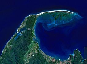
NASA satellite image of Farewell Spit. Whanganui Inlet can be seen centre left.
|
|
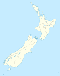
| Location | Tasman District |
| Nearest city | Nelson |
Whanganui Inlet is a large natural bay on the northwest coast of New Zealand's South Island. It is located in the Tasman District. This special place is known for its beautiful natural state and rich wildlife.
Contents
What is Whanganui Inlet?
Whanganui Inlet is like a long, narrow arm of the sea. It was once a river valley that got filled with ocean water. This type of landform is called a "drowned river valley." The inlet runs alongside the west coast of the South Island.
Size and Location
The inlet is about 13 kilometers (8 miles) long. It is also around 2.5 kilometers (1.5 miles) wide on average. A small channel connects the inlet to the Tasman Sea. This channel is about 19 kilometers (12 miles) southwest of a famous sand spit called Farewell Spit.
Nature and Protection
Whanganui Inlet is still very natural and untouched. It has many areas of seagrass and salt marsh. These plants create a perfect home for lots of sea creatures. Because it is so important for wildlife, much of the inlet is protected.
Wildlife Management Area
A large part of the inlet is a wildlife management area. This means it is a special place where animals are protected. It helps keep the natural environment safe for all the creatures that live there.
Westhaven Marine Reserve
The inlet is also home to the Westhaven Marine Reserve. A marine reserve is like a national park, but for the ocean. In a marine reserve, sea life is protected, and certain activities like fishing might be limited. This helps fish and other marine animals thrive.
Fun Activities
Whanganui Inlet is a popular spot for outdoor activities. Many people enjoy fishing in its waters. It is also a great place for boating. Visitors can explore the calm waters and enjoy the beautiful scenery.


