Wheatland, Oklahoma facts for kids
Quick facts for kids
Wheatland
|
|
|---|---|

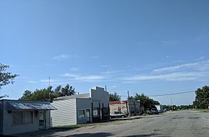
Main Street in Wheatland, 2019
|
|
| Country | United States |
| State | Oklahoma |
| County | Oklahoma |
| Elevation | 1,319 ft (402 m) |
| Population
(2000)
|
|
| • Total | 39 |
| Time zone | UTC-6 (Central (CST)) |
| • Summer (DST) | UTC-5 (CDT) |
| ZIP codes |
73097, 73169
|
| GNIS feature ID | 1100120 |
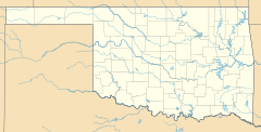
Wheatland is a small neighborhood in the southwestern part of Oklahoma City, Oklahoma, United States. It is located along State Highway 152. The area uses ZIP Codes 73097 and 73169.
Contents
Discovering Wheatland's Past
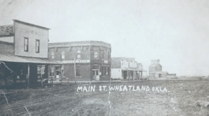
Wheatland was once a small town in the countryside. It became part of Oklahoma City in 1910. The town got its name from its main crop, which was wheat.
Early Days of Wheatland
The town's post office opened on February 10, 1902. In the same year, the local church was built. These were important steps for the growing community.
The Town Bank and Its Journey
A bank was built in Wheatland in 1904. It was first called the Farmer's State Bank of Wheatland. Later, in 1922, its name changed to First National Bank of Wheatland.
During the Great Depression, many towns faced tough times. Wheatland was one of them. The bank eventually moved in 1941 and became the First National Bank of Bethany. This showed how much the town had changed.
The Wheatland Weekly Watchword Newspaper
From 1909 to 1914, a newspaper called The Wheatland Weekly Watchword was published. It was put out by the Suburban Newspaper Publishing Company. The newspaper shared poems, local news, and even national stories. Hula Lisel was the editor.
Population Changes in Wheatland
In 1942, the population of Wheatland was 183 people. This number shows how small the community was at that time.
 | Calvin Brent |
 | Walter T. Bailey |
 | Martha Cassell Thompson |
 | Alberta Jeannette Cassell |


