Willow Brook Estates, Illinois facts for kids
Quick facts for kids
Willow Brook Estates
|
|
|---|---|

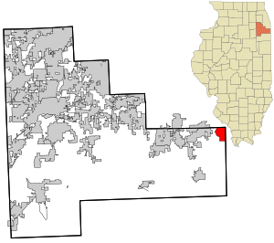
Location in Will County and the state of Illinois.
|
|
| Country | United States |
| State | Illinois |
| County | Will |
| Area | |
| • Total | 3.4 sq mi (9 km2) |
| • Land | 3.4 sq mi (9 km2) |
| • Water | 0.04 sq mi (0.1 km2) |
| Elevation | 715 ft (218 m) |
| Population
(2020)
|
|
| • Total | 1,346 |
| • Density | 396/sq mi (152.9/km2) |
| Time zone | UTC-6 (CST) |
| • Summer (DST) | UTC-5 (CDT) |
| Area code(s) | 708 |
| Website | www.willowbrook123.com |
Willow Brook Estates is a small community in Will County, Illinois, United States. It is called an unincorporated community because it does not have its own local government like a city or town. It is also a census-designated place (CDP), which means the U.S. Census Bureau counts it as a separate area for population statistics.
In 2020, about 1,346 people lived in Willow Brook Estates. This community is located south of Chicago, a large city in Illinois.
Contents
History of Willow Brook Estates
Willow Brook Estates started as a planned neighborhood in 1971. It was developed by John Parker, Evelyn Parker, and Ronald Parker. The community was built in three stages between 1971 and 1991. It has 161 different land lots for homes.
In the middle of the neighborhood, there is a large body of water called Park Pond. Willow Brook Estates is known for being one of the biggest and oldest unincorporated communities in Illinois. It is managed by a Homeowners Association (HOA). An HOA is a group that sets rules for the community and helps maintain common areas.
Even though it has a similar name, Willow Brook Estates is quite far from the Village of Willowbrook in DuPage County. They are about 47 miles apart.
Geography of Willow Brook Estates
Willow Brook Estates is located at 41°27′00″N 87°32′28″W / 41.449925°N 87.541120°W.
The community is found northeast of where East Exchange Street and Stateline Road meet. It shares a border with the state of Indiana to its east. The town of Crete, Illinois is about 8 miles to the west of Willow Brook Estates.
According to the United States Census Bureau, the entire area of Willow Brook Estates is about 3.4 square miles (8.8 square kilometers). Most of this area, 3.4 square miles, is land. A very small part, about 0.04 square miles (0.10 square kilometers), is water.
Population Information
| Historical population | |||
|---|---|---|---|
| Census | Pop. | %± | |
| 2000 | 2,130 | — | |
| 2010 | 2,076 | −2.5% | |
| 2020 | 1,346 | −35.2% | |
| U.S. Decennial Census 2010 2020 |
|||
Population in 2020
The most recent count of people in Willow Brook Estates was in 2020. At that time, 1,346 people lived there. This number was lower than in previous years.
Population in 2010
In 2010, the population of Willow Brook Estates was 2,076 people. The community had 726 households. The average number of people living in each household was about 2.93. The median age of people living in the CDP was 43 years old.
See also
 In Spanish: Willowbrook (Illinois) para niños
 | Percy Lavon Julian |
 | Katherine Johnson |
 | George Washington Carver |
 | Annie Easley |

