Wing, Alabama facts for kids
Quick facts for kids
Wing, Alabama
|
|
|---|---|

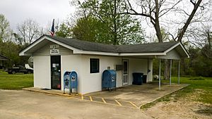
Post office in Wing
|
|
| Country | United States |
| State | Alabama |
| County | Covington |
| Elevation | 266 ft (81 m) |
| Time zone | UTC-6 (Central (CST)) |
| • Summer (DST) | UTC-5 (CDT) |
| ZIP code |
36483
|
| Area code(s) | 334 |
| GNIS feature ID | 129115 |
Wing is a small community in Covington County, Alabama, in the United States. It's called an "unincorporated community" because it doesn't have its own city government. Instead, it's managed by the county.
Where is Wing Located?
Wing is found inside the beautiful Conecuh National Forest. It's located right on Alabama State Route 137, which is a road that goes through the area. If you travel about 20 miles (32 kilometers) south-southwest from the city of Andalusia, you'll reach Wing. The community also has its own post office with the ZIP code 36483.
Black History Month on Kiddle
Famous African-American Scientists:
 | Charles R. Drew |
 | Benjamin Banneker |
 | Jane C. Wright |
 | Roger Arliner Young |

All content from Kiddle encyclopedia articles (including the article images and facts) can be freely used under Attribution-ShareAlike license, unless stated otherwise. Cite this article:
Wing, Alabama Facts for Kids. Kiddle Encyclopedia.


