Wiota (community), Wisconsin facts for kids
Quick facts for kids
Wiota, Wisconsin
|
|
|---|---|

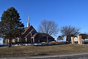
Wiota Lutheran Church
|
|
| Country | |
| State | |
| County | Lafayette |
| Town | Wiota |
| Area | |
| • Total | 2.001 sq mi (5.18 km2) |
| • Land | 2.001 sq mi (5.18 km2) |
| • Water | 0 sq mi (0 km2) |
| Elevation | 997 ft (304 m) |
| Population | |
| • Estimate
(2017)
|
97 |
| • Density | 48.5/sq mi (18.7/km2) |
| Time zone | UTC-6 (Central (CST)) |
| • Summer (DST) | UTC-5 (CDT) |
| Area code(s) | 608 |
| GNIS feature ID | 1576892 |
| FIPS code | 55-88025 |
Wiota is a small, friendly community located in Lafayette County, Wisconsin, in the United States. It's known as an unincorporated community, which means it doesn't have its own local government like a city or town. Instead, it's part of the larger town of Wiota.
Wiota is also a census-designated place (CDP). This is a special area that the U.S. Census Bureau defines for counting people. It helps them gather information about how many people live in certain areas. In 2017, about 97 people lived in Wiota.
You can find Wiota on Wisconsin Highway 78. It's about 6.2 miles (10 kilometers) southwest of a town called Argyle.
Where is Wiota Located?
Wiota is in the eastern part of Lafayette County. This county is in the southwest area of Wisconsin. The community sits on a raised area, like a small hill.
Land and Water
According to the U.S. Census Bureau, the Wiota community covers an area of about 2.0 square miles (5.2 square kilometers). All of this area is land; there are no large bodies of water within the community itself.
Local Waterways
Wiota is located near the start of Feather Branch. This is a small stream that flows south. It eventually joins the Pecatonica River, which is a larger river in the region.
 | Dorothy Vaughan |
 | Charles Henry Turner |
 | Hildrus Poindexter |
 | Henry Cecil McBay |


