Wolf Plains facts for kids
Quick facts for kids |
|
|
Wolf Plains
|
|

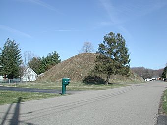
One of the mounds
|
|
| Nearest city | Athens, Ohio |
|---|---|
| Area | 2,300 acres (930 ha) |
| NRHP reference No. | 74001399 |
| Added to NRHP | May 31, 1974 |
The Wolf Plains Group is a collection of ancient earthworks built by the Adena culture. These people lived in the Ohio Valley a very long time ago. The group includes 30 earthworks, such as 22 round mounds and nine circular enclosures.
Wolf Plains is located near The Plains, Ohio, which was once called Wolf's Plains. This area is a flat terrace in the hilly landscape of southeastern Ohio. It sits in the Hocking River valley. This flat land was formed by ancient glaciers.
Contents
Discovering Ancient Earthworks
The Wolf Plains Group was first written about in a famous book. This book was called Ancient Monuments of the Mississippi Valley. It was published in 1848 by Ephraim George Squier and Edwin Hamilton Davis.
Early Maps and Mistakes
Squier and Davis based their drawings on a sketch from 1836. This sketch was made by S. P. Hildreth. However, their finished drawing had some small mistakes. For example, some groups of mounds were turned the wrong way. Also, some mounds were missing, and others were not in the right place.
What are Earthworks?
Earthworks are large structures made by shaping the ground. The Adena people built these mounds and enclosures for different reasons. They might have been used for burials, ceremonies, or as special gathering places.
Protecting History: Saving the Mounds
Many of these ancient earthworks are still on private land. This means they are at risk of being destroyed as towns grow. People want to build new homes and businesses.
Efforts to Preserve the Sites
In 2008, a group called The Archaeological Conservancy bought one of the remaining earthworks. This one is known as the Dorr 2 Mound. They used special funds to buy it. This group plans to buy more of these important sites when they have enough money.
National Register of Historic Places
The Wolf Plains Group was added to the National Register of Historic Places on May 31, 1974. This is a list of places in the United States that are important to history. When it was added, 25 of the earthworks were still in good enough shape to be included.
Images for kids
 | Madam C. J. Walker |
 | Janet Emerson Bashen |
 | Annie Turnbo Malone |
 | Maggie L. Walker |


