Wrightsville, Adams County, Ohio facts for kids
Quick facts for kids
Wrightsville, Ohio
|
|
|---|---|

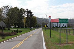
Wrightsville community sign on Ohio State Route 247 South
|
|
| Country | United States |
| State | Ohio |
| County | Adams |
| Township | Monroe |
| Time zone | UTC-5 (Eastern (EST)) |
| • Summer (DST) | UTC-4 (EDT) |
| ZIP codes |
45144 (Manchester)
|
| Area code(s) | 937 |
| GNIS feature ID | 1061804 |
Wrightsville is a small, quiet place in Adams County, Ohio. It's known as an unincorporated community. This means it's a group of homes and businesses that isn't officially a city or town with its own local government. Instead, it's part of the larger county.
A Look Back at Wrightsville
Wrightsville was officially planned and marked out on a map in 1847. This process is called "platting." It means someone laid out the streets and land plots for future homes and buildings.
For many years, Wrightsville had its own post office. It first opened in 1850 and was called Mahala. Later, in 1857, its name changed to Vineyard Hill. The post office served the community until it closed its doors in 1907.
Images for kids
Black History Month on Kiddle
African-American Astronauts:
 | Stephanie Wilson |
 | Charles Bolden |
 | Ronald McNair |
 | Frederick D. Gregory |

All content from Kiddle encyclopedia articles (including the article images and facts) can be freely used under Attribution-ShareAlike license, unless stated otherwise. Cite this article:
Wrightsville, Adams County, Ohio Facts for Kids. Kiddle Encyclopedia.


