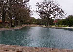
Yanaguana (San Antonio) facts for kids
Yanaguana was a village where the Payaya people lived a long time ago. This area is now the city of San Antonio in Texas, USA. Some people think the Payaya also called the San Antonio River "Yanaguana." Today, you might hear this name used to attract tourists to the river. For example, the National Park Service has a "Yanaguana Trail" near Mission San Juan Capistrano. In 1933, a group called the Yanaguana Society was started. They wanted to collect and save old items and stories from the San Antonio area. This group was named after the Payaya village and worked until 1960.
Contents
First European Visits
The first time Europeans wrote about Yanaguana was in 1691. A Spanish priest named Damián Massanet traveled through the area with soldiers.
Massanet's Discoveries
On June 13, 1691, Father Massanet wrote in his diary. He named the area San Antonio de Padua. But he noted that the Payaya people called their village Yanaguana. He described many different trees and lots of water. He also saw good fishing and many wild chickens.
The Payaya People
The Payaya were a group of Coahuiltecan people. They moved around a lot, meaning they were nomadic. They camped at Yanaguana because it had so much to offer. The natural resources there, like water and food, helped their village survive.
Renaming the Area
In 1709, another Spanish priest, Isidro de Espinosa, gave the area a new name. He called it Agua de San Pedro, which means "Waters of San Pedro." Later, in 1852, the city of San Antonio turned part of Yanaguana into San Pedro Springs Park.
Founding San Antonio
In 1718, a Spanish colonizer named Martín de Alarcón arrived at Yanaguana. He played a big part in starting the city of San Antonio.
Establishing Missions and Presidios
Alarcón helped set up two important places:
- The San Antonio de Valero mission
- The Presidio San Antonio de Bexar (a fort)
These were built on land that was already home to the Payaya people. On May 1, 1718, Alarcón officially handed over the mission to Father Antonio de Olivares. The mission was first made of simple huts. It was moved across the river a year later. In 1724, the mission moved again to where the Alamo is today.
Public Land Decree
In 1729, King Philip V of Spain made the area public land. This meant it belonged to the Spanish government.
 | Frances Mary Albrier |
 | Whitney Young |
 | Muhammad Ali |


