Yarrawarrah facts for kids
Quick facts for kids YarrawarrahSydney, New South Wales |
|||||||||||||||
|---|---|---|---|---|---|---|---|---|---|---|---|---|---|---|---|

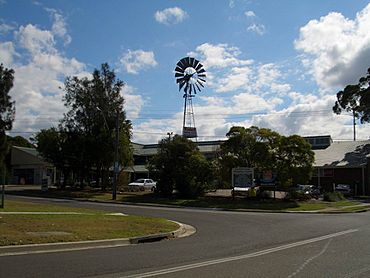
Yarrawarrah Shopping Village, Old Bush Road
|
|||||||||||||||
| Population | 2,775 (2021 census) | ||||||||||||||
| Established | 1971 | ||||||||||||||
| Postcode(s) | 2233 | ||||||||||||||
| Elevation | 166 m (545 ft) | ||||||||||||||
| Location |
|
||||||||||||||
| LGA(s) | Sutherland Shire | ||||||||||||||
| State electorate(s) | Heathcote | ||||||||||||||
| Federal Division(s) | Hughes | ||||||||||||||
|
|||||||||||||||
Yarrawarrah is a friendly suburb located in southern Sydney, New South Wales, Australia. It's about 32 kilometers south of the main city area. This suburb is part of the Sutherland Shire local government area.
The original people of Yarrawarrah are the Tharawal people. The name Yarrawarrah comes from an Aboriginal word. It means "mountain ash," which is a type of tall tree. Yarrawarrah was also the name of a ridge (a long, narrow hill) in the area.
Contents
History of Yarrawarrah
Before Yarrawarrah became an official suburb in 1971, this area was known as North Engadine. The first pieces of land were bought in 1887 by Charles McAlister. He was an early developer in the nearby Engadine area. This happened after the Illawarra railway line opened in 1886.
Early Settlers and Challenges
In the 1920s, the first families to live here were soldiers returning from World War I. Later, during the Great Depression, more families moved from inner Sydney. In the 1930s, some families were even moved here from unemployment camps.
In 1952, big bushfires caused a lot of damage in the area. This showed how difficult it was to get in and out of the suburb. Because of this, a new community group started in 1959. It met in front of the general store on Old Bush Road.
Becoming a Suburb
In 1962, the State Housing Commission announced plans for a new suburb. It would be built on 80 acres (about 32 hectares) of land. This land was between Loftus and Engadine, next to the North Engadine settlement.
The local primary school was built on Old Bush Road in 1968. It was first going to be called Engadine North Public School. However, the Geographical Names Board said no. They chose Yarrawarrah instead. This name came from the Aboriginal word for mountain ash and a nearby ridgeline.
Some people thought the new suburb might take over North Engadine. Others worried that Engadine itself might grow to include the whole area. So, in 1971, the Geographical Names Board officially named the area Yarrawarrah.
Growth and Development
In the 1970s, the Princes Highway was changed, which made it easier to get to Yarrawarrah. These road improvements were finished in 1975. People asked for a train station in 1979, but the council said no.
In 1983, the Sutherland council gave money to build a new community hall. It was named Yarrawarrah Community Hall. The North Engadine Scout Hall is still right next to it. The new hall opened in 1984. Throughout the 1990s, more local services and shops were added. This helped meet the needs of the growing number of residents.
Population Facts
In 2021, there were 2,775 people living in Yarrawarrah. Most people, about 84.9%, were born in Australia. The next largest group, 3.5%, were born in England. Almost everyone, 92.1%, spoke only English at home. When it came to religion, 33.6% said they had no religion. About 27.8% were Catholic, and 19.8% were Anglican.
Natural Surroundings
Yarrawarrah is next to the beautiful Royal National Park. It has many areas of bushland. The suburb is quite hilly and stretches down to the valley of Engadine. You can find several fire trails here, like Turrella and Fairy Creek.
Many streets in Yarrawarrah are named after places in Western Australia and South Australia. Examples include Nullabor Place and Gibson Street. Other streets have Aboriginal themes, like animals and plants. Some streets are named after heroes from wars, like Victoria's Cross recipients.
Local Places to Visit
Yarrawarrah has a small shopping village. It has a special landmark: a windmill! Here you can find a doctor's office, a pharmacy, a hair salon, and restaurants. There's also a convenience store for quick needs. The windmill became quite popular in November 2009.
Across the road from the shops is the Yarrawarrah Community Hall. You can rent the main hall for events, which fits 90 people standing or 70 seated. There's also a smaller meeting room. The North Engadine Scout Hall is right next door.
Yarrawarrah also has a community-run weather station. It's connected to the internet and shares local weather information.
Education
Yarrawarrah Public School opened in 1968. It is located on Old Bush Road, just behind the shopping village.
Sports and Recreation
Yarrawarrah has two main sports fields:
- Old Bush Road Oval: This oval is on Old Bush Road. It's home to the Engadine Lions Rugby Union Club. National Touch Rugby Australia games are also played here.
- Yarrawarrah Reserve: This field is at the corner of Giles Street and Wheatley Road. It's where the Yarrawarrah Tigers Junior Rugby League Football Club plays. The Yarrawarrah Tigers Junior Baseball Club also uses this reserve.
Getting Around
The Princes Highway is the main road that runs along the east side of Yarrawarrah. People asked for a wooden train platform way back in 1936, but it was never built. Later, in the 1970s, there were more requests for a train station. However, the council said no in 1979.
The closest train stations are Engadine and Loftus. Buses also serve the area. You can catch Transdev NSW routes 991 and 993 here.


