South Gull Lake, Michigan facts for kids
Quick facts for kids
South Gull Lake, Michigan
|
|
|---|---|

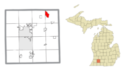
Location within Kalamazoo County
|
|
| Country | United States |
| State | Michigan |
| County | Kalamazoo |
| Township | Ross |
| Area | |
| • Total | 3.15 sq mi (8.15 km2) |
| • Land | 1.35 sq mi (3.50 km2) |
| • Water | 1.80 sq mi (4.66 km2) |
| Elevation | 879 ft (268 m) |
| Population
(2020)
|
|
| • Total | 1,179 |
| • Density | 872.69/sq mi (337.06/km2) |
| Time zone | UTC-5 (Eastern (EST)) |
| • Summer (DST) | UTC-4 (EDT) |
| FIPS code | 26-74975 |
| GNIS feature ID | 1867323 |
South Gull Lake is a special kind of community in Michigan, a state in the United States. It is known as a census-designated place (CDP). This means it's an area that the government counts for population, but it doesn't have its own official city government.
South Gull Lake is located in Kalamazoo County, specifically in Ross Township. It includes smaller communities like Yorkville, Gull Lake, and Midland Park. In 2020, about 1,179 people lived here.
Contents
Exploring South Gull Lake's Location
South Gull Lake is found in the northeast part of Kalamazoo County. It sits around the southern and eastern edges of a beautiful body of water called Gull Lake.
Where is Gull Lake?
Gull Lake is quite large! Parts of it stretch into nearby Richland Township and even a tiny bit into Barry County. However, the main community of South Gull Lake focuses on the southern and eastern shores.
Key Communities Around the Lake
- Yorkville is in the southern part of South Gull Lake. It's where water flows out of Gull Lake into Gull Creek.
- The community named Gull Lake is at the very southeast tip of the lake.
- Midland Park is located on the eastern side of the lake.
For a short time, from 1917 to 1939, Yorkville even had its own summer post office!
Roads and Travel
A state highway called M-89 runs along the southern edge of South Gull Lake. This road can take you about 3.5 miles west to the town of Richland. If you go east on M-89, you'll reach Battle Creek in about 12 miles. The larger city of Kalamazoo is about 12 miles southwest, usually reached by going through Richland.
Land and Water Area
The entire South Gull Lake area covers about 8.2 square kilometers (or 3.15 square miles). More than half of this area, about 57%, is water! This means the lake itself is a very important part of the community. The water from Gull Lake flows out through Gull Creek, which then leads south to the Kalamazoo River.
People of South Gull Lake
The population of South Gull Lake has changed over the years. In 2000, there were 1,526 people living here. By 2010, the number had decreased slightly to 1,182. The most recent count in 2020 showed a population of 1,179 people.
Homes and Families
In 2000, there were 643 households in South Gull Lake. A household is a group of people living together in one home. Most of these households (about 61.7%) were married couples. About 27.2% of homes had children under 18 living there. The average household had about 2.37 people.
Age Groups
The people in South Gull Lake come from all age groups. In 2000:
- About 23.4% of the population was under 18 years old.
- About 16.1% of the population was 65 years old or older.
The median age in the community was 45 years. This means half the people were younger than 45, and half were older.
See also
 In Spanish: South Gull Lake para niños


