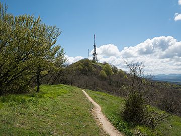
Zaldiaran facts for kids
Quick facts for kids Zaldiaran |
|
|---|---|

Summit of Zaldiaran
|
|
| Highest point | |
| Elevation | 978 m (3,209 ft) |
| Prominence | 175 m (574 ft) |
| Geography | |
| Location | Álava, Basque Country, Spain |
| Parent range | Montes de Vitoria |
| Climbing | |
| Easiest route | Hike |
Zaldiaran is a mountain located in the Montes de Vitoria mountain range. You can find it in the province of Álava, which is part of the Basque Country in Spain.
Even though a small part of the mountain's southern side is in the Treviño exclave (which belongs to Burgos), the very top of Zaldiaran is in Álava. At the summit, there's a tall metal cross. This cross was put there in 1950 by the Manuel Iradier hiking club. You'll also see some large antennas at the top. These antennas send TV and radio signals to the city of Vitoria-Gasteiz.
Near the top of Zaldiaran is the Zaldiaran pass. This pass is about 780 meters (2,559 feet) high. It connects Álava with the Treviño exclave. The roads that link these two areas are the A-3102 in Álava and the BU-742 in Treviño. The northern slopes of the mountain are covered with beech trees. Lower down, you'll find woods of Portuguese oak trees.
Because Zaldiaran is close to Vitoria-Gasteiz and easy to reach, it's a very popular spot for hikers. On New Year's Day, hiking clubs from the city often organize trips to the mountain. They do this to celebrate the start of the new year.
Hiking Zaldiaran: Popular Trails
The most common way to hike Zaldiaran starts in Berrostegieta. This village is on the road that leads to the Zaldiaran pass. This path takes you over a smaller peak called Errogana first.
Another popular place to begin your hike is the nearby small village of Eskibel. The quickest way to reach the summit is to start directly at the Zaldiaran pass. From there, you can follow a paved track that goes all the way to the top.
See Also
In Spanish: Zaldiaran para niños
 | Selma Burke |
 | Pauline Powell Burns |
 | Frederick J. Brown |
 | Robert Blackburn |

