
Zavodovski Island facts for kids

NASA image of Zavodovski Island
|
|

Zavodovski Island
Location in Atlantic Ocean
Location in South Georgia and the South Sandwich Islands.
|
|
| Geography | |
|---|---|
| Location | Southern Ocean |
| Coordinates | 56°18′S 27°34′W / 56.300°S 27.567°W |
| Area | 14.7 km2 (5.7 sq mi) |
| Length | 5 km (3.1 mi) |
| Width | 5 km (3.1 mi) |
| Highest elevation | 551 m (1,808 ft) |
| Highest point | Mount Asphyxia |
| Administration | |
| Demographics | |
| Population | uninhabited |

Zavodovski Island is a small, uninhabited volcanic island in the South Sandwich Islands. It's part of a group called the Traversay Islands. This island is located about 350 kilometers (217 miles) southeast of South Georgia Island.
It's the northernmost island in the South Sandwich chain. Zavodovski Island is famous for being home to a huge colony of chinstrap penguins. There are about a million pairs of these penguins living and breeding here! This makes it one of the largest penguin colonies outside of Antarctica.

Contents
Exploring Zavodovski Island
Discovery and Naming
Zavodovski Island was first discovered by a Russian explorer named Fabian Gottlieb von Bellingshausen. He found the island on December 23, 1819. Bellingshausen named it after Captain-Lieutenant Ivan Zavadovsky. Zavadovsky was the captain of Bellingshausen's ship, the Vostok.
A year later, on December 24, 1820, a small group from the expedition landed on the island. This group included Ivan Zavadovskiy, astronomer Ivan Simonov, and Lieutenant Dmitriy Demidov. They collected volcanic rocks and observed the birds and penguins living there.
Later Visits and Studies
In 1830, an American ship called the Pacific also landed on Zavodovski Island. Later, in 1930, scientists from the Discovery Investigations (DI) explored and mapped the island.
Zavodovski Island and its amazing penguin colony have been featured in famous nature documentaries. It appeared in the "Frozen Seas" episode of the BBC series The Blue Planet in 2001. It was also shown in the "Islands" episode of Planet Earth II in 2016.
Volcanic Activity
Zavodovski Island is an active volcano. On May 2, 2012, a volcanic eruption was detected on the island. The exact size of this eruption is not known.
The volcano erupted again in March 2016. By July of that year, a large part of the island, between one-third and one-half, was covered in ash. This ash put the large penguin colonies at risk.
Island Geography
.jpg)
Zavodovski Island is mostly free of glaciers. It measures about 5.6 kilometers (3 nautical miles) across. The highest point on the island reaches 551 meters (1,808 feet) above sea level.
Many of the island's points and bluffs have been named. These names often reflect the strong, sulfur-like smell from the volcano. The United Kingdom Antarctic Place-Names Committee (UK-APC) gave most of these names.
- Reek Point is the northernmost point of the island.
- Pacific Point is on the northwest side. It was renamed in 1953 after the ship Pacific.
- Acrid Point is a low-lying area to the southwest.
- Stench Point is a noticeable point on the west side of the island.
- Noxious Bluff is a dark cliff about 50 meters (164 feet) high on the southwest coast.
- Fume Point is a low lava feature at the southern tip of the island.
- Pungent Point is a low, dark lava cliff on the east side.
Mount Asphyxia
The western part of Zavodovski Island is dominated by Mount Asphyxia. This is a type of volcano called a stratovolcano. It's also sometimes known as Mount Curry. Mount Asphyxia is an active volcano. There have been reports of fresh lava since 1830, and many signs of activity since then. About half of the island is made up of tephra. Tephra is the rocky material that is thrown out during volcanic eruptions.
Images for kids
-
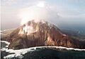
View of Mount Asphyxia
-
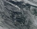
A plume of smoke rising from Zavodovski volcano
See also
 In Spanish: Isla Zavodovski para niños
