
Álora facts for kids
Quick facts for kids
Álora
|
|||
|---|---|---|---|

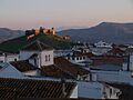
Álora seen from the castle, with mountain Hacho behind.
|
|||
|
|||

Municipal location in the Province of Málaga
|
|||

Álora
Location in Spain
|
|||
| Country | |||
| Autonomous community | Andalusia | ||
| Province | Málaga | ||
| Comarca | Valle del Guadalhorce | ||
| Area | |||
| • Total | 79.26 km2 (30.60 sq mi) | ||
| Elevation | 222 m (728 ft) | ||
| Population
(2018)
|
|||
| • Total | 12,951 | ||
| • Density | 163.399/km2 (423.20/sq mi) | ||
| Demonyms | Perotes, Aloreños | ||
| Postal code |
29500, 29510
|
||


Álora is a cool town and municipality in southern Spain. It is located in the province of Málaga, within the Andalusia region. Álora is about 40 kilometers from the city of Málaga. It sits on the right side of the Guadalhorce river.
This town is a classic pueblo blanco, which means "white village". It is tucked between three rocky hills. On top of these hills, you can see the ruins of an old castle. The area of Álora is about 169 square kilometers. It includes many of the big hills and valleys of Málaga. The hills have fields of grain, olive trees, and oak trees. The valley floor has lots of fruit and vegetable farms. Around 13,000 people live in Álora.
The history of Álora goes way back to prehistoric times. This means people lived here a very long time ago. The area was good for hunting and had plenty of water. Later, groups like the Tartessos and Phoenicians found the area useful for trade. The Phoenicians likely built the first parts of the castle. The Romans later made it even stronger. The people who live in Álora are known as Perotes.
Contents
What Does "Perote" Mean?
The name "Perote" has a few possible stories. One popular idea is that it comes from the first mayor, Don Pero. He was mayor right after the Catholic Monarchs took back the area. Because of him, a part of the area was called "The Perocia."
Exploring Álora's Geography
Álora is like a crown in the Valle del Guadalhorce. It sits between three hills, right next to the Guadalhorce river. It is also on the railway line that connects Málaga with cities like Seville, Córdoba, and Granada. The towers of its castle stand tall over the town. They used to be lookouts to watch people and goods moving inland. The town itself is safely tucked between two small hills and Mount Hacho, which is 559 meters high.
The area around Álora is very large and has some of Málaga's most famous natural spots. To the north, you can find the amazing El Chorro natural area. This includes the Sierra de Huma, a mountain 1,191 meters high, and the Desfiladero de los Gaitanes. This gorge is home to the famous Caminito del Rey, a walkway built along the cliffs. It was named after King Alfonso XIII who opened it.
To the west, the Sierra de Aguas mountain range stretches into Álora's land. This area is part of the Serranía de Ronda mountains. It has many pine forests. This beautiful landscape goes from the Guadalhorce river to the road that links Álora with Carratraca.
Álora's Long History
People have lived in the Álora area since prehistoric times. The Tartessos and Phoenicians used its good location for trading. The Phoenicians probably built the first castle here. When the Romans took over Spain, they fixed up the fortress. It became a Roman town called Iluritanum around 79 BC.
The castle was made even bigger by the Visigoths. But it was the Moors who really expanded it after they conquered Spain. Álora became an important fort for Umar ibn Hafsun. He was a powerful local leader who ruled from Bobastro during the time of the emirate of Córdoba. Christian armies from northern Spain tried many times to capture Álora. They finally succeeded in 1484.
Álora had a good time during the 16th and 17th centuries. In 1628, it became independent from the city of Málaga. In the 20th century, many people from Álora moved away. They went to places like Argentina, Germany, Australia, and Switzerland to find new opportunities.
Main Places to See
Álora's castle is a must-see. It was first built by the Phoenicians and then made bigger by the Romans. In the 5th century, the Visigoths almost destroyed it. But the Moors rebuilt it. You can still see parts from the Moorish time, like a fancy steel door and a traditional Arab mirador (a viewpoint).
Other interesting places to visit include:
- The church and convent of Nuestra Señora de Flores, built in the 16th century.
- The Iglesia de la Veracruz, also from the 16th century.
- The church of Nuestra Señora de la Encarnación. This church is built where the castle's mosque used to be. It has a special crucifix made by José Navas Parejo.
- The chapel of St. Brigida, from the 16th century.
- The chapel of Las Torres, built in the 15th century in a late Gothic style.
Getting Around Álora
The best way to get to Álora from Málaga is by using the Cercanías train. This is a local train line, Line 2. It travels up the valley of the Guadalhorce river. You can catch it from Málaga Centro-Alameda or Málaga María Zambrano. The trip takes about 40 minutes for 40 kilometers. If you arrive at the airport, you can take Cercanías Line 1 to Málaga Victoria Kent or María Zambrano and then switch to Line 2.
Buses are also a main way to travel around Álora and nearby villages. These buses are run by the Málaga Metropolitan Transport Consortium.
Images for kids
-
View of Álora

See also
 In Spanish: Álora para niños
