Île Vanier facts for kids

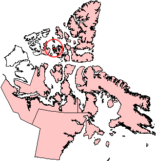
Île Vanier, Nunavut.
|
|
| Geography | |
|---|---|
| Location | Northern Canada |
| Coordinates | 76°10′N 103°15′W / 76.167°N 103.250°W |
| Archipelago | Queen Elizabeth Islands Canadian Arctic Archipelago |
| Area | 1,126 km2 (435 sq mi) |
| Length | 53 km (32.9 mi) |
| Width | 35 km (21.7 mi) |
| Administration | |
| Territory | Nunavut |
| Demographics | |
| Population | 0 |
Île Vanier is a cool island located far north in Nunavut, Canada. It is one of the many islands that make up the Canadian Arctic Archipelago. This island is part of the Queen Elizabeth Islands, a large group of islands in the Arctic. No people live on Île Vanier, making it a wild and untouched place.
Contents
About Île Vanier
Where is Île Vanier?
Île Vanier is found at 76°10'N latitude and 103°15'W longitude. It is a part of Nunavut, which is a large territory in northern Canada. The island is surrounded by cold Arctic waters.
Size and Neighbors
This island is quite big! It covers an area of about 1,126 square kilometers (435 square miles). That's like a really large city! It is about 53 kilometers (33 miles) long and 35 kilometers (22 miles) wide.
Île Vanier has other islands nearby. To its north, across a narrow water channel called the Arnott Strait, is Cameron Island. To the south, across another channel called the Pearse Strait, is Massey Island.
Island History
The first time anyone recorded seeing Île Vanier was in 1851. This sighting was made by an explorer named Robert D. Aldrich. However, back then, they weren't sure if it was a single island or part of a larger landmass. It wasn't until the 1950s that explorers finally proved Île Vanier was its own separate island.
Mountains and Landforms
Even though it's an Arctic island, Île Vanier has some hills and higher ground. The Adam Range is a group of hills or low mountains on the island. These hills can reach heights of more than 220 meters (720 feet) above sea level.
See also
 In Spanish: Isla Vanier para niños
 | Emma Amos |
 | Edward Mitchell Bannister |
 | Larry D. Alexander |
 | Ernie Barnes |


