Massey Island facts for kids

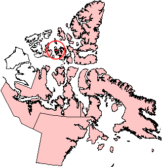
Location of Île Vanier near Massey Island
|
|
| Geography | |
|---|---|
| Location | Arctic Ocean |
| Coordinates | 75°59′N 102°58′W / 75.983°N 102.967°W |
| Archipelago | Canadian Arctic Archipelago |
| Area | 432 km2 (167 sq mi) |
| Length | 47 km (29.2 mi) |
| Width | 34 km (21.1 mi) |
| Administration | |
|
Canada
|
|
| Territory | Nunavut |
| Region | Qikiqtaaluk |
| Demographics | |
| Population | Uninhabited |
Massey Island is a quiet, uninhabited island located in Canada's far north. It is part of the Bathurst Island group, which is found in the Arctic Ocean. This island is part of the Nunavut territory, specifically the Qikiqtaaluk Region.
Where is Massey Island Located?
Massey Island is in the vast Arctic Ocean. It lies south of another island called Île Vanier, with a narrow waterway known as Pearse Strait separating them. To its south, across Boyer Strait, are Alexander Island and Île Marc.
The island is part of the Canadian Arctic Archipelago. This is a huge collection of islands in northern Canada. It belongs to the Nunavut territory, which is one of Canada's three territories.
How Big is Massey Island?
Massey Island covers an area of about 432 square kilometers (167 square miles). It is approximately 47 kilometers (29 miles) long and 34 kilometers (21 miles) wide. Because it is so far north and its climate is very cold, no people live on Massey Island.
Who Was Vincent Massey?
The island is named after Vincent Massey. He was a very important person in Canadian history. Vincent Massey served as the Governor General of Canada from 1952 to 1959. The Governor General is the King or Queen's representative in Canada. This role involves many important duties, like making sure the government runs smoothly and representing Canada at events.
See also
 In Spanish: Isla Massey para niños
 | Aurelia Browder |
 | Nannie Helen Burroughs |
 | Michelle Alexander |


