
2011 Tarlay earthquake facts for kids
| UTC time | 2011-03-24 13:55:13 |
|---|---|
| ISC event | 16357310 |
| USGS-ANSS | ComCat |
| Local date | 24 March 2011 |
| Local time | 20:25:13 (UTC+06:30) |
| Magnitude | 6.8 Mw |
| Depth | 10 km (6.21 mi) |
| Epicenter | 20°39′54″N 99°53′06″E / 20.665°N 99.885°E |
| Max. intensity | VIII (Severe) |
| Casualties | 75–151 killed, 212 injured |
On March 24, 2011, a strong Mw 6.8 earthquake hit Shan State in Myanmar. Its center was near the borders of Myanmar, Thailand, and Laos. This earthquake caused a lot of damage and sadness.
Between 75 and 151 people lost their lives, including one person in Thailand. Many hundreds of buildings were damaged in both Myanmar and Thailand. Also, 212 people were hurt during the earthquake.
Contents
Why Earthquakes Happen Here
Earthquakes happen when large pieces of the Earth's crust, called plates, move and rub against each other. This earthquake happened because the Indo-Australian Plate is slowly pushing into the Eurasian Plate. This pushing created the Arakan Yoma mountains.
Most of this movement happens along a big crack in the Earth called the Sagaing fault. This fault runs through Myanmar. It's a type of fault where the two sides slide past each other sideways. Other smaller faults in eastern Myanmar, Thailand, and Laos also help to release this pressure. Two of these faults, the Mae Chan and Nam Ma faults, are very close to where the earthquake started.
The 2011 Earthquake

Scientists studied how the ground moved during this earthquake. They found that the ground slid sideways along a crack that went straight down. This earthquake was one of the biggest in the Golden Triangle area. This region has seen other large earthquakes in the past, like in 1976, 1988, and 1995.
The Nam Ma Fault
The Nan Ma Fault is a long crack in the Earth that stretches for 215 kilometers through Myanmar, Laos, and China. Long ago, this fault moved in one direction. But now, it moves in the opposite direction, sliding sideways at about 0.6 to 2.4 millimeters per year.
The earthquake happened on one of the smaller branches of the Nam Ma Fault. It was like a small crack coming off the main fault line.
Cracks on the Ground
The earthquake caused a 30-kilometer-long crack on the surface of the Earth. This crack, called a surface rupture, was along the western part of the Nam Ma Fault. In some places, the ground moved almost 2 meters sideways.
Scientists used satellite data to see how much the ground moved underground. They found that the biggest movement, about 4 meters, happened about 3 to 5 kilometers deep. People saw clear cracks in farm fields. In one area, a 2-kilometer-long crack was mapped. The ground moved between 0.12 meters and 1.25 meters there. In Tarlay, the ground moved several tens of centimeters.
How Much the Ground Shook
The ground shook strongly for about 24 seconds during the earthquake. This shaking was especially bad for buildings that were not too tall. The sideways shaking was the main reason why many buildings were destroyed.
The strongest shaking ever recorded in Thailand from an earthquake happened 28 kilometers south of the earthquake's center, in Mae Sai. This shows how powerful the shaking was.
What Happened After the Earthquake

In Myanmar, between 74 and 150 people died, and 212 were injured. Over 3,152 people lost their homes, and 18,000 people were affected. At least 413 buildings were damaged, and one bridge collapsed in Shan State.
About 90 villages were badly damaged. In 50 of these villages, more than half the buildings were destroyed. In 40 other villages, over 30 percent of buildings were damaged. The damage in Tarlay was very severe. At least 40 people died in Tarlay, and one hospital fell down. The ground also sank 1.5 meters near a bridge between Kengtung and Tachileik.
In Tachileik, two people died and six were injured. In Kyakuni village, 25 people died and 57 were injured when a church collapsed during a service. In Monglin, at least 128 homes were destroyed. Many Buddhist monasteries and government buildings were also damaged.

In Mae Sai, Thailand, one person died when a wall fell. Sixteen people were also injured. Buildings cracked, and the top of an old temple fell off. Even though no buildings completely collapsed, the ground moved in other ways, like turning soft in some places. The shaking was strong in Mae Sai.
People felt the shaking in Chiang Rai and Bangkok, causing panic. In Hanoi, Vietnam, windows broke, and some people left their homes. Strong shaking was also felt in Laos, but no one was hurt there, and nothing was damaged. In China, some homes and schools cracked. Tall buildings in several cities were emptied for a short time.
News reports said that many injured people at Tachilek Hospital "disappeared" after journalists reported on the damage. The hospital was very busy with about 700 patients. Hospital workers said local officials sent survivors away after media shared news about the damage and injuries. Some local people also said that up to 200 people might have died in Shan State.
Helping After the Earthquake
After the earthquake, most people in Tachileik slept outside because officials warned them about more shaking. Many people did not go back to their homes, and businesses were closed. It was hard for helpers to reach some injured people because roads were blocked. Power, water, and phone services were also sometimes cut off. A damaged bridge in Tarlay made it difficult for aid to reach the town.
On March 25, the Myanmar government sent relief supplies like tents, blankets, clothes, and food by plane. Two days later, government officials visited the affected areas, meeting with people who lost their homes. Families received money, clothes, and food. Patients at the hospital also received money. Officials also checked on repairs to important roads and bridges. By March 27, buses and small cars could use the roads and bridge again.
Other countries also helped. China gave US$500,000 to help with relief and rebuilding. Thailand gave ฿3 million to Myanmar and promised more help. India's prime minister said his government would give US$1 million for "relief and rehabilitation." Aid groups like Malteser International and World Vision also provided emergency help, including shelters, food, and water.
See also
 In Spanish: Terremoto de Birmania de 2011 para niños
- List of earthquakes in 2011
- List of earthquakes in Myanmar
- List of earthquakes in Thailand
- 1912 Maymyo earthquake
Images for kids
-
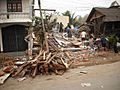
Dozens of houses were destroyed in Shan State
-
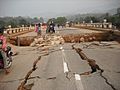
A damaged road in Tarlay, Shan State
