
2013 El Reno tornado facts for kids
|
Clockwise from top: View of the tornado near its peak size; severe home damage; a radar loop of the storm.
|
|
| Meteorological history | |
|---|---|
| Duration | 40 minutes |
| Formed | May 31, 2013, 6:03 pm. CDT (UTC−05:00) |
| Dissipated | May 31, 2013, 6:43 pm. CDT (UTC−05:00) |
| EF3 tornado | |
| on the Enhanced Fujita scale | |
| Path width | 4,576 yards (2.60 mi; 4.18 km) (Worldwide record width) |
| Path length | 16.2 miles (26.1 km) |
| Highest winds |
|
| Satellite tornadoes | |
| Tornadoes | 3 |
| Maximum rating | EF2 tornado |
| Overall effects | |
| Fatalities | 8 |
| Injuries | 151 |
| Areas affected | Canadian County, Oklahoma; especially areas to the south of El Reno |
|
Part of the tornado outbreak of May 26–31, 2013 and tornadoes of 2013 |
|


The 2013 El Reno tornado was a giant, powerful tornado in Central Oklahoma. It formed on May 31, 2013, near the city of El Reno. Scientists consider it the widest tornado ever measured in history. At its biggest point, the spinning storm stretched 2.6 miles (4.2 km) across. It was part of a larger weather system that caused severe storms across the region.
This huge storm had dangerous winds and changed directions without warning. Because it moved mostly over open farm fields, it destroyed fewer buildings than expected. However, mobile weather radar instruments measured winds over 313 mph (504 km/h) inside smaller spinning air funnels. The National Weather Service called it "the most dangerous tornado in storm observing history."
Contents
How the 2013 El Reno Tornado Formed

On May 31, 2013, weather scientists noticed ideal conditions for creating severe thunderstorms. A large upper-level trough with low pressure moved toward the Dakotas and the Upper Midwest. Fast winds from the polar jet blew across the southern Rocky Mountains toward the southern Great Plains. Warm, moist air moved north, making the air mass completely unstable through the Mississippi Valley.
The dewpoint reached around 70 degrees Fahrenheit (21 degrees Celsius), while temperatures rose into the 80s. Meteorologists calculated high CAPE energy values, which measured the potential explosive energy of the storm. Strong shifts in wind speed and direction, known as wind shear, were also present.
These ingredients gathered near a cold front and a dry boundary called a dry line in western Oklahoma and Texas. The Storm Prediction Center warned that rotating thunderstorms called supercells could form. They predicted dangerous hail and tornadoes across Missouri and Oklahoma. By mid-afternoon, experts issued a special Particularly Dangerous Situation Tornado Watch near Interstate 44.
The Path and Size of the Record-Breaking Storm
Storm Development Across Canadian County
Around 4:00 p.m., severe thunderstorms quickly developed near Highway 81. A National Weather Service office in Norman, Oklahoma soon issued an urgent tornado warning for Canadian County. At 6:03 p.m. CDT, a rotating wall cloud touched the ground about 8.3 miles (13.4 km) from El Reno.
The funnel started as a multiple-vortex tornado, which means several smaller funnels spin inside the main funnel. The storm took a strange path, making a complete loop before turning east-southeast. By 6:23 p.m., it crossed U.S. 81 and grew to its record-breaking width of 2.6 miles (4.2 km). This broke the previous record set by the 2004 Hallam, Nebraska tornado.
The weather service warned nearby cities like Yukon, Bethany, The Village, and western parts of the Oklahoma City metropolitan area. Luckily, the tornado turned toward Interstate 40 and lifted off the ground after traveling 16.2 miles (26.1 km). A smaller, spinning companion called an anticyclonic satellite tornado also spun nearby during the event.
How Scientists Rated the Storm's Intensity
Scientists had many debates about how to rate this tornado's official strength. Meteorologists usually measure storms using the ground damage Enhanced Fujita Scale. Official ground surveys found damage matching an EF3 rating. However, mobile Doppler radar run by the University of Oklahoma using RaXPol technology recorded winds exceeding 296 mph (476 km/h).
Some readings even showed brief wind gusts reaching 313 mph (504 km/h). These speeds rivaled the famous 1999 Bridge Creek–Moore tornado. Because the fastest winds hit open fields instead of solid buildings, the official rating stayed EF3.
Impact on Storm Chasers and Residents

Many researchers practice storm chasing to study severe weather, but this storm was exceptionally dangerous. Wrapping curtains of heavy rain completely hid the giant funnel from view. The tornado also changed its speed and direction suddenly, trapping several vehicles on dirt roads.
Famous scientist Tim Samaras, leader of the TWISTEX project, was caught in the storm. Samaras, his son Paul, and research partner Carl Young sadly lost their lives. Another local motorist also died in that area. Other weather experts, including Mike Bettes from The Weather Channel and chaser Reed Timmer, survived major damage to their vehicles.
In nearby Oklahoma City, thousands of people tried to drive away during afternoon rush hour. Many remembered the terrible damage from the 2013 Moore tornado just eleven days earlier. Highways like Interstates 35 and 240 became trapped in traffic jams. Weather safety experts remind everyone that cars are very dangerous during tornadoes. People should always seek shelter in strong, windowless interior rooms or basements instead.
Aftermath and Community Recovery

The storm caused extensive damage to several rural properties, barns, and metal power poles. The livestock market and the Canadian Valley Technology Center both suffered millions of dollars in damages. The violent winds tore asphalt and gravel right off country roads. In total, eight people died and 151 people were injured during the disaster.
After the storm passed, the American Red Cross opened an emergency shelter at Redlands Community College. Oklahoma Governor Mary Fallin visited the damaged areas to organize relief. Because an official state of emergency was already active, families received rapid help and temporary housing. Local hospitals, including OU Medical Center, helped care for all the injured residents.
Images for kids
-
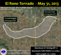
Map showing the path and width of the El Reno tornado.
-
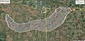
Minute-by-minute timeline diagram of the tornado's movement.
-
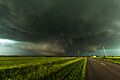
The massive tornado near its peak size.
-
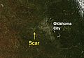
Satellite view of the ground scar left across the fields.


See also
 In Spanish: Tornado de El Reno de 2013 para niños
