
Abadín facts for kids
Quick facts for kids
Concello de Abadín
|
|||
|---|---|---|---|
 |
|||
|
|||

Situation of Abadín within Galicia
|
|||
| Parroquias | ? | ||
| Area | |||
| • Total | 196.1 km2 (75.7 sq mi) | ||
| Population
(2018)
|
|||
| • Total | 2,428 | ||
| Time zone | UTC+1 (CET) | ||
| • Summer (DST) | UTC+2 (CET) | ||


Abadín is a small town, also called a municipality, located in the Lugo province of Galicia, Spain. It's a beautiful area known for its green landscapes. The municipality covers about 196 square kilometers, which is roughly the size of a medium-sized city. About 2,400 people live here, making it a quiet and peaceful place.
Contents
Exploring Abadín's Geography
Abadín is found in the northeast part of a region called Terra Chá. This area is known for its flat lands. The municipality has several important natural features. It is crossed by the Serra do Xistral and the Cordal de Neda, which are both mountain ranges. Rivers like the Labrada and the Abadín also flow through the area.
The average height of the land in Abadín is about 500 meters above sea level. The very highest point is called Lombo Pequeno. It reaches an impressive 1,015 meters high.
Abadín's Landscape
The countryside of Abadín is mostly a very fertile valley. This means the land is good for growing crops. Many rivers and streams wind their way through this valley. Some of these rivers include the Ouro, Labrada, Abadín, and Anllo.
Tall mountains surround this green valley. Important mountain ranges here are the Cordal de Neda, Toxoso, and Tremoal. There are also nearby mountains like Costa do Sol and O Picouto.
Abadín's Climate
The weather in Abadín is generally cool. The average temperature throughout the year is about 10 degrees Celsius. It rains a lot here, with about 1,799 millimeters of rain each year.
Winters are usually cold and wet. Summers, however, tend to be dry. This mix of weather helps keep the landscape green and lush.
Understanding Abadín's Mountains
The shape of Abadín's land is mainly a fertile valley. This valley is surrounded by many mountains. These mountains create two main types of landforms.
First, there are mountain ridges like the Sierra de Carba in the west. The Sierra del Gistral is in the northwest. The Sierra de Toxiza is in the northeast. These mountains form the northern edge of the Lugo plateau.
Second, there is a gently rolling area of land. This area is between 400 and 600 meters high. The only significant hill in this part is Neda's Peak, which is 796 meters high. The highest point in all of Abadín is Lombo Pequeño. It is 1,027 meters high and is part of the Sierra del Gistral.
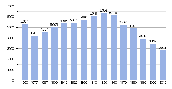
Population Changes in Abadín
Demography is the study of how populations change over time. This includes how many people live in a place and how that number goes up or down.
The chart below shows how Abadín's population has changed over many years. You can see the number of people living there in different years.
Notable Mountains in Abadín
Abadín is home to many mountains and peaks. Here are a few examples of the highest or most well-known ones:
- Lombopequeno (1,015 m)
- Río Pedrido (1,005 m)
- Ladeiras do Seixobranco (962 m)
- Airavella (961 m)
- Pena da Auga (831 m)
- Coto da Cal (807 m)
These mountains add to the beautiful and varied landscape of Abadín.
See also
 In Spanish: Abadín para niños
