Aconbury Camp facts for kids

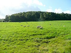
Aconbury Hill viewed from the north
|
|
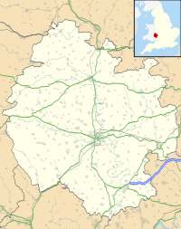
| Location | Near Hereford, Herefordshire |
|---|---|
| Coordinates | 51°59′37″N 2°43′28″W / 51.99361°N 2.72444°W |
| Type | Hillfort |
| Length | 500 metres (1,600 ft) |
| Width | 137 metres (449 ft) |
| Area | 7 hectares (17 acres) |
| History | |
| Periods | Iron Age |
| Designated | 26 November 1928 |
| Reference no. | 1001754 |
Aconbury Camp is an ancient fort from the Iron Age. It sits on Aconbury Hill in Herefordshire, England. This historic site is about 6.4 kilometers (4 miles) south of Hereford. It is also close to the village of Aconbury. Today, Aconbury Camp is a protected scheduled monument. This means it is an important historical place.
Contents
What is Aconbury Camp?
Aconbury Camp is a type of old fort called a hillfort. It was built a very long time ago. The fort has one main wall, called a rampart. This wall is made of earth and stones. Outside the rampart, there is a deep ditch. This ditch helped protect the fort from enemies.
How Big is Aconbury Camp?
The fort covers an area of about 7 hectares (17 acres). That's roughly the size of 10 football fields! It stretches about 500 meters (1,640 feet) from west to east. It is also about 137 meters (450 feet) wide.
Entrances and Walls
Aconbury Camp has special entrances. These are found at the south-east and south-west corners. They are called "inturned entrances." This means the walls curve inwards at the entrance. This design made it harder for attackers to get in. The rampart wall is quite tall. It rises about 3 meters (10 feet) above the inside of the fort. In some places, it can be as wide as 5.5 meters (18 feet).
Discoveries at Aconbury Camp
Archaeologists are like history detectives. They study old sites to learn about the past. Aconbury Camp was carefully studied between 1948 and 1951.
What Did They Find?
During the studies, archaeologists found some interesting things. They discovered that the rampart walls likely had internal revetments. These are structures that support the wall from the inside. They also found many pieces of broken pottery. These broken pieces are called sherds. Most of the sherds were from the prehistoric Iron Age. Some Roman pottery was found too.
Life in the Iron Age
The pottery found at Aconbury Camp tells us about the people who lived there. It suggests that people lived and worked here. Their way of life was similar to those at other nearby hillforts. These include Dinedor Camp and Sutton Walls.
Aconbury Camp in Later History
Aconbury Hill was important even after the Iron Age. It played a small role during the English Civil War. This war happened in England in the 1600s.
During the English Civil War
In 1642, a Royalist army briefly took over the hill. This army was led by Lord Herbert. Later, in 1645, a Scottish army occupied the hill. This army was under the command of the Earl of Leven. Armies would often use hills like Aconbury. They offered a good view of the surrounding area. This made them great places for defense or to watch for enemies.
Images for kids


