Adare Peninsula facts for kids
Quick facts for kids Adare Peninsula |
|
|---|---|

Adare Peninsula
|
|
| Highest point | |
| Geography | |
| Geology | |
| Mountain type | Shield volcanoes |
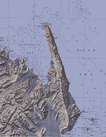
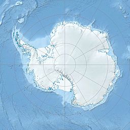
The Adare Peninsula is a long, ice-covered piece of land sticking out into the ocean in Antarctica. It's about 40 miles (64 km) long. You can find it in the northeast part of Victoria Land, stretching from Cape Adare in the north down to Cape Roget in the south. This peninsula is the most southern part of the Borchgrevink Coast, which is named after an explorer named Carsten Borchgrevink. The peninsula itself was named after Cape Adare by a group in New Zealand that names places in Antarctica.
The Adare Peninsula is made up of several shield volcanoes that overlap each other. Scientists have studied these volcanoes and found that they are very old. Some parts are between 6 and 13 million years old. Other parts are younger, around 1 to 2 million years old. These volcanoes are part of a larger group called the McMurdo Volcanic Group.
Contents
Exploring the Adare Peninsula
The Adare Peninsula has many interesting features. Explorers have named different parts of it over the years. Let's take a look at some of these important places.
West Coast Features
The west side of the peninsula has several famous spots.
Cape Adare
Cape Adare is a very noticeable point of land. It's made of black basalt rock. This cape forms the northern tip of the Adare Peninsula. It is also the most northeastern point of Victoria Land.
Ridley Beach
Just south of Cape Adare on the west side is Ridley Beach. This beach is shaped like a triangle, about 1 nautical mile (1.85 km) long on each side. It was an important camping spot for early explorers.
- The British Antarctic Expedition 1898–1900, led by C.E. Borchgrevink, camped here. Borchgrevink named the camp after his mother's maiden name.
- Later, in 1911, another group from the British Antarctic Expedition (1910–13) landed here. They named the whole beach "Ridley."
- Ridley Beach is also home to a large group of Adélie penguins.
Von Tunzelman Point
The very western tip of Ridley Beach is called Von Tunzelman Point. It was named in 1984. This name honors Alexander von Tunzelman. He was part of the first group known to land in Victoria Land back in 1895.
Boulder Rock and Seal Point
- Right next to Ridley Beach is Boulder Rock. This is a large rock in the sea. It was first mapped and named in 1911 by the Northern Party of the British Antarctic Expedition. This group was led by Victor Campbell.
- About 3.5 nautical miles (6.5 km) south of Boulder Rock is Seal Point. This point was also mapped and named in 1911 by the same Northern Party.
Adare Saddle
Inland from the coast, the peninsula meets the Admiralty Mountains. The Adare Saddle is the area where these mountains connect with the peninsula.
East Coast Features
Many of the features on the east side of the peninsula were discovered and named by Captain James Clark Ross in 1841.
Downshire Cliffs
A large part of the east side of the peninsula is a line of very steep basalt cliffs. These cliffs rise up to 2,000 meters (6,560 feet) high. They are known as the Downshire Cliffs. Captain Ross originally named a part of these cliffs "Cape Downshire." He did this at the request of Commander Francis R.M. Crozier. Even though there isn't one single cape there, the name is still used for these impressive cliffs.
Nestling Rock
Nestling Rock is a smaller rock located in the sea. It lies just south of the northern part of the Adare Peninsula. Its name suggests how it "nests" beside the huge Downshire Cliffs.
Fenwick Ice Piedmont
The Fenwick Ice Piedmont is a large area of ice on the east side of the Adare Peninsula. It is formed by many glaciers flowing down from the peninsula. This ice area is located between the Downshire Cliffs and Cape McCormick. It was named in 2005 to honor Rob Fenwick. He worked hard to protect important historical sites in Antarctica that are cared for by New Zealand.
Cape McCormick
Further south, Cape McCormick marks the eastern end of the Adare Peninsula. Captain Ross named it after Robert McCormick (explorer). He was a surgeon on one of Ross's ships.
Cape Roget
Cape Roget is a steep, rocky cape at the southern tip of the east coast of the Adare Peninsula. It marks the northern side of the entrance to Moubray Bay. This cape was named after Peter Mark Roget, who was famous for creating a thesaurus. Cape Roget is also home to a group of Emperor penguins.
See also
 In Spanish: Península Adare para niños
 | Bayard Rustin |
 | Jeannette Carter |
 | Jeremiah A. Brown |


