Adrar Province facts for kids
Quick facts for kids
Adrar Province
ولاية أدرار
|
|
|---|---|

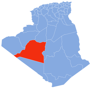
Map of Algeria highlighting Adrar
|
|
| Country | |
| Capital | Adrar |
| Area | |
| • Total | 439,700 km2 (169,800 sq mi) |
| Population
(2008)
|
|
| • Total | 402,197 |
| • Density | 0.91471/km2 (2.36908/sq mi) |
| Time zone | UTC+01 (CET) |
| Area Code | +213 (0) 49 |
| ISO 3166 code | DZ-01 |
| Districts | 11 |
| Municipalities | 28 |
Adrar Province is a large region in the southwestern part of Algeria, a country in North Africa. It's named after its main city, Adrar, which is also its capital. This province is the second-largest in Algeria by land area.
Imagine a huge desert landscape, and that's a big part of Adrar. It covers about 439,700 square kilometers. In 2008, about 402,197 people lived here. The province is governed by a Wāli, which is like a governor, and also has a People's Provincial Assembly.
Exploring Adrar's Regions
Adrar Province is divided into smaller parts to help manage it. These parts are called districts and communes. Think of them like counties and towns.
Districts of Adrar Province
The province has 11 main districts. Each district contains several smaller towns or areas known as communes or municipalities. There are 28 communes in total across Adrar Province.
Here are the 11 districts:
- Adrar
- Aougrout
- Aoulef
- Bordj Badji Mokhtar
- Charouine
- Fenoughil
- Reggane
- T'Sabit
- Timimoun
- Tinerkouk
- Zaouiet Kounta
See also
 In Spanish: Provincia de Adrar para niños
 | William M. Jackson |
 | Juan E. Gilbert |
 | Neil deGrasse Tyson |

