
Agriculture in prehistoric Scotland facts for kids

Imagine Scotland long, long ago, before written history began! This article is all about how people farmed the land in Scotland during prehistoric times. This means we'll look at farming from the Stone Age, Bronze Age, and Iron Age.
People in ancient Scotland learned to grow crops and raise animals. This was super important for getting food. Scotland has less good farming land compared to England and Wales. Most of the best land is in the south and east. Heavy rain often created boggy, acidic land, especially in the west. Also, mountains and marshes made farming and travel tricky.
Around 6,000 years ago, during the Neolithic period, people started living in one place and farming. They mostly grew grain and raised cows for milk. Later, in the Bronze Age, more land was used for farming. But as the climate changed, some upland farms were left empty. By the Iron Age, people built hill forts in southern Scotland. These forts were often near farmed areas. They also built underground storage places called souterrains for food. Even today, we can see signs of ancient farms under modern fields in some areas. This shows that people were already farming a lot of the good land.
Contents
Scotland's Land and Climate in Prehistory

Scotland is about half the size of England and Wales. It has a lot of coastline, but only a small amount of good farming land. Most of this good land is in the south and east, below 60 metres (about 200 feet) above sea level. This meant that raising animals and fishing were very important ways to get food.
Scotland gets a lot of rain because it's close to the Atlantic Ocean. This rain helped create large areas of peat bog. Peat bogs are acidic and, combined with strong winds, made many western islands treeless. Hills, mountains, and wet areas also made farming and moving around difficult for early people.
Long, long ago, during an ice age, glaciers covered most of Britain. Scotland became a place where people could live again around 9600 BCE. The first known people were hunter-gatherers. They moved around a lot and used boats. They made tools from bone, stone, and animal antlers. The oldest house found in Britain is from this time, around 8240 BCE, near South Queensferry.
Neolithic Farming: New Ways of Life

The Neolithic period began about 6,000 years ago. This is when people started living in permanent homes and farming. One example is a settlement at Dunning in Perthshire, from about 3800 to 3700 BCE. Here, archaeologists found faint marks from early ploughs. These were probably simple hand-held tools called ards that scratched the soil.
You can also see well-preserved stone houses at Knap of Howar on Papa Westray. These homes are from around 3500 BCE. The village of Skara Brae on Orkney is another famous example, built about 500 years later. These places show how people began to settle down.
Evidence of early farming includes small fields with simple stone walls. In Shetland, these old fields have been found under peat. On the mainland, they are near piles of rocks that farmers cleared from their fields. People also cleared oak and birch trees, mainly for their animals to graze.
Archaeologists study things like pollen, pottery, and human remains. They tell us that the main foods were grain and cow's milk. This way of eating probably stayed the same for a very long time. There's also some evidence that people grew flax, which can be used for cloth.
Bronze Age Farming: Growing and Changing
The Bronze Age started around 2000 BCE. During this time, more and more land was used for growing crops. Forests of oak and birch trees were cut down or cleared. This happened in areas where it was easy to get to, like near rivers. People cleared land by letting animals graze, or by using "slash and burn" methods. This means cutting down trees and burning them to clear the land.
However, towards the end of the Bronze Age, the climate got worse. This meant that farming in the uplands (higher areas) was stopped. Farming became more focused on the lowlands. Even though the soil might have gotten worse, people found ways to keep it fertile.
We've found scattered signs of field systems from this period. Some areas have long walls, which suggests people were raising animals. Places like the Scord of Brouster show enclosed fields with walls and piles of cleared rocks. This means the landscape was carefully managed.
One discovery at North Mains suggests that fields might have had ridges. These ridges would have helped with drainage and growing crops. Important crops included barley and flax. Oats were not grown as a crop yet; they grew wild.
Iron Age Farming: Forts and Fields
The Iron Age began in Scotland around the seventh century BCE. This is when hill forts first appeared. Some of these forts in southern Scotland are found near old cultivation ridges and terraces. These show where people farmed.
Over 400 souterrains have been found in Scotland. These are small underground structures, many in the south-east. Most were built around the second or third centuries CE. They were usually close to settlements and were likely used to store food that could spoil easily.
There are also about 100 unique circular stone towers called brochs. They probably date from about 200 BCE. Many had ditches or walls around them. They likely protected valuable farming land and the people who lived there.
Pictures taken from the air show huge ancient field systems under today's fields in some Lowland areas. This tells us that the fertile plains were already heavily farmed. People cleared a lot of oak, elm, and hazel trees. They used the wood for fuel, especially near settlements and main roads.
Animals raised during this time included sheep, and smaller numbers of cattle and pigs. When the Romans were in northern England and sometimes came into southern Scotland, birch and oak trees started to grow back for about 500 years. This might mean that the Roman invasions caused a decrease in farming and the local population.
See Also
Images for kids
-
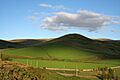
Park Law Iron Age settlement near Sourhope in the Borders, was the site of an agricultural settlement during the Iron Age. Nearby hillsides have prominent lynchets or cultivation rigs.
-
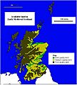
Map of available land in early Scotland.
-
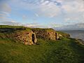
The houses at Knap of Howar, showing the start of settled farming in Scotland.
-
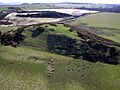
Peace Knowe Hillfort, West Lothian. From their introduction in the Iron Age hillforts became major centres of agriculture.

