Aguán River facts for kids
Quick facts for kids Aguán River |
|
|---|---|
 |
|
|
Location of the mouth
|
|
| Country | Honduras |
| Physical characteristics | |
| Main source | Yoro |
| River mouth | Caribbean 15°52′19″N 85°37′47″W / 15.87194°N 85.62972°W |
| Length | 240 km (150 mi) |
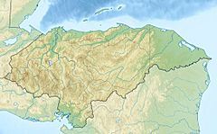
The Aguán River is a major river in Honduras. It is also commonly called the Río Aguán in Spanish. This important river begins in the Yoro region. It flows east-northeast before reaching the Caribbean Sea.
About the Aguán River
The Aguán River is about 240 kilometers (150 miles) long. It starts in the Yoro region, west of a town called San Lorenzo. The river then flows past towns like San Lorenzo, Olanchito, and Tocoa. Finally, it empties into the Caribbean Sea, near Puerto Castilla.
Hurricane Mitch and the River
In 1998, a very strong storm called Hurricane Mitch hit Honduras. This hurricane caused the Aguán River to overflow its banks in many places. The amount of water flowing in the river became extremely high.
Sadly, the village of Santa Rosa de Aguán was badly affected. The river's powerful floodwaters washed away the village. This event caused many people to lose their lives.
The River's Importance
The area drained by the Aguán River is called its watershed. This watershed is one of seven important river areas in Honduras. It covers a very large space, over 1 million hectares (about 3,860 square miles).
A big part of this area is the Aguán River Valley. This valley is especially important for farming. It is known as the Bajo Aguán, and it is a major agricultural region in Honduras.
See also
 In Spanish: Río Aguán para niños
 | Audre Lorde |
 | John Berry Meachum |
 | Ferdinand Lee Barnett |


