Alamor facts for kids
Quick facts for kids
Alamor
|
|
|---|---|
|
Town
|
|

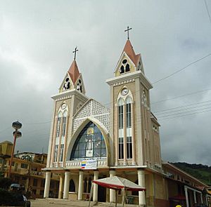
Iglesia San Jacinto de Alamor
|
|
| Country | Ecuador |
| Province | Loja Province |
| Canton | Puyango Canton |
| Area | |
| • Town | 1.63 km2 (0.63 sq mi) |
| Population
(2022 census)
|
|
| • Town | 5,981 |
| • Density | 3,669/km2 (9,504/sq mi) |
| Time zone | ECT |
| Climate | Aw |
| Website | www.hcpl.gov.ec / Puyango Canton |
Alamor is a town located in the Loja Province of Ecuador. It is the main town, also known as the "seat," of the Puyango area.
Contents
Where is Alamor Located?
Alamor is in the southwestern part of Loja Province. It shares borders with other areas like Avocados and El Oro Province to the north. To the south, it borders Celica and Pindal. To the east, you'll find Celica and Zapotillo, and to the west, it borders the country of Peru.
Alamor is about 214 kilometers (133 miles) from Loja, the capital city of the province. It's also 140 kilometers (87 miles) from the city of Machala.
- Latitude: 4°02' South
- Longitude: 80°01' West
- Height above sea level: 1,380 meters (4,528 feet)
- Average temperature: 18 °C (64 °F)
- Town area: 1.63 square kilometers (0.63 square miles)
- Population (2022 census): 5,981 people
What is the Climate Like?
Puyango, the canton where Alamor is located, has a pleasant climate. It's generally warm and a bit humid. In the lower areas, temperatures can reach 26 °C (79 °F). In other parts, the temperature usually stays between 14 °C (57 °F) and 18 °C (64 °F).
Symbols of Puyango
The town of Alamor is part of Puyango Canton, which has its own special symbols.
The Shield
The official shield of Puyango is divided into four sections. It shows important things like the Puyango River, the sun, the canton's flag, farming tools, and cattle. Around the outside, you can see coffee and corn plants. These represent the main crops grown in the area. The shield also includes the canton's name and the date it was officially recognized.
The Flag
The flag of Puyango has three horizontal stripes, all the same size.
- The top stripe is yellow.
- The middle stripe is green.
- The bottom stripe is white.
The Anthem
The hymn, or anthem, for the parish of Alamor was written by Dr. Luis Antonio Aguirre Alamor. The shield and flag of Puyango were officially approved on January 23, 1966. Later, in 1979, Dr. Marcelo Reyes Orellana wrote the words for the current Puyango hymn. This hymn became official on December 3, 1989.
Mountains and Rivers
The area around Puyango has two main mountain ranges: Alamor and Laborers. Important peaks include Black and Curiachi Cerro. The Limo mountain range also has several branches, like Canoas and Puerto Nuevo.
Rivers
- Puyango River: This is the largest river. It forms the border with El Oro Province and Peru. It flows into the Pacific Ocean and is known as the Tumbes River in Peru.
- Alamor River: This river starts in the foothills of Guachanama. It flows through Pindal and Zapotillo before its waters reach the Pacific Ocean.
- Other important streams in the area include Ingenio, Cochurco, and Shoa (Tunima).
What Does Alamor Produce?
Alamor is known for its agricultural products and livestock.
Crops
The main crops grown here are:
- Coffee
- Corn
- Bananas
- Brown sugar (from sugar cane, used to make rum)
- Citrus fruits like oranges and lemons
- Other tropical fruits
Livestock
Farmers in Alamor also raise:
- Cattle
- Pigs
- Horses
- Poultry (like chickens)
How to Get Around: Roads
Alamor is connected by several roads.
Main Highways
- Loja to Alamor
- Alamor to Arenillas
Secondary Roads
- Alamor to Vicentino
- Alamor to Ciano
- Alamor to Arenal
- Alamor to Silt
- Alamor to Mangaurco
- Alamor to The Collapsed Puyango (Old Bridge)
- Alamor to Chaquinal
- Alamor to Pindal
Festivals and Celebrations
Alamor and the Puyango Canton celebrate several important events throughout the year. These include both civic (community) and religious festivals.
- January 23: This day celebrates the anniversary of Puyango becoming a canton.
- July 16: A commercial and religious celebration in honor of the Virgin of El Carmen.
- August 15: Another commercial and religious celebration, this time for the Virgin of the Assumption.
- September 14: A commercial and religious celebration in Mercadillo, honoring Señor del Girón.
- December 8: A commercial and religious celebration for the Immaculate Conception.
Images for kids
See also
 In Spanish: Alamor para niños
 | Claudette Colvin |
 | Myrlie Evers-Williams |
 | Alberta Odell Jones |


