
Aldeadávila de la Ribera facts for kids
Quick facts for kids
Aldeadávila de la Ribera
|
||
|---|---|---|
|
municipality
|
||
|
||

Location in Salamanca
|
||

Aldeadávila de la Ribera
Location in Spain
|
||
| Country | Spain | |
| Autonomous community | Castile and León | |
| Province | Salamanca | |
| Comarca | Vitigudino | |
| Subcomarca | La Ribera de Salamanca | |
| Area | ||
| • Total | 46 km2 (18 sq mi) | |
| Elevation | 679 m (2,228 ft) | |
| Population
(2018)
|
||
| • Total | 1,239 | |
| • Density | 26.93/km2 (69.8/sq mi) | |
| Time zone | UTC+1 (CET) | |
| • Summer (DST) | UTC+2 (CEST) | |
| Postal code |
37250, 37251, 37253
|
|

Aldeadávila de la Ribera is a small village and a municipality in western Spain. It is located in the Salamanca province, which is part of the Castile and León region.
-
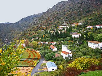
Salto de Aldeadávila village
-
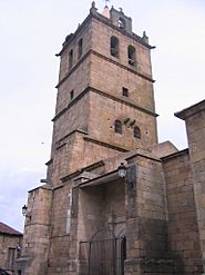
Church of Saint Saviour
-
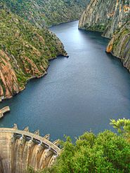
Aldeadávila Dam


Contents
Exploring Aldeadávila de la Ribera
Aldeadávila de la Ribera is in the northwest of the Salamanca province. It shares a border with Portugal. The village is about 60 miles from the city of Salamanca.
It is part of a special area called La Ribera. This area is known for its beautiful natural park.
Towns and Villages
The municipality of Aldeadávila includes a few different places. The main town is Aldeadávila de la Ribera itself. This is where the town hall is located.
- Corporario: This village is very close to Aldeadávila. They are so close they almost look like one big town. Corporario used to be its own municipality. Its church is very old and beautiful.
- Salto de Aldeadávila: This small village is in the Duero river valley. It has been around since the 12th century. It was once home to hermits. Today, only about 20 people live there.
Natural Beauty and Landforms
Aldeadávila de la Ribera is mostly made up of gentle hills. This is typical for the Northern Plateau region. However, it also has deep river beds carved by the Duero River. The land here ranges from about 2,200 to 2,500 feet high. The highest point is Pico de la Cabeza. The lowest point is the Duero River bank.
The area is part of the Iberian Massif. This is a large geological area in Spain. You can find two main types of rocks here. There are granitoids, which are like granite. These are the rocks where the Aldeadávila dam was built. There are also schists and slates. These are layered rocks.
The most amazing natural feature is the Duero River canyon. It is a very deep cut in the land. This canyon is over 60 miles long. It is one of the biggest river canyons in Spain. It is also a special geological site.
The whole area is part of the Arribes del Duero natural park. This park is a protected natural area. It attracts many tourists and scientists.
Famous Places and Sights
Aldeadávila de la Ribera has many interesting places to visit. From old buildings to stunning natural viewpoints.


Aldeadávila Dam
The Aldeadávila Dam is probably the most famous place here. It is part of a system of dams on the Duero River. These dams produce hydroelectric power. The dam is located in the Arribes del Duero area. The river banks here are very steep, over 1,300 feet high in some places.
Parts of famous movies like Doctor Zhivago were filmed here. The dam was officially opened in 1964. You can see it from several viewpoints. These include the dam's own viewpoint, Picón de Felipe, and Fraile viewpoint. This dam produces a lot of electricity. It is the dam with the highest electricity production in Spain.
Church of Saint Saviour
The church has a tall tower. This tower was first built as a military fortress in the 13th century. It was meant to defend the town. It still has an old Romanesque door. Its walls are very thick, more than two meters wide. In the 16th century, the tower was connected to the church. It became the church's bell tower.
The church itself started being built in the 13th century. It was refurbished a lot between the 15th and 16th centuries. Inside, it has a beautiful Baroque altarpiece from the 17th century. Chapels were added in the 18th century.
The village of Salto de Aldeadávila is also very picturesque. It is on the road to the Aldeadávila dam. It has the Convent of La Verde. This convent was built between the 12th and 18th centuries. It is also known as the Convent of Santa Marina.
Other Historical Sites
- El Encinar necropolis: This is an old burial site. It has five stone tombs scattered on a hillside.
- Corporario Church: This church dates back to the 13th and 14th centuries. It has an old Roman stele and part of a human-shaped tomb.
- Hermitages: There are several small chapels called hermitages. These include Santo Cristo del Humilladero (17th century) and Nuestra Señora de las Huertas (18th century). The hermitage of San Sebastián (13th-19th century) now serves as a tourist office.
- Historic Crosses: You can find old crosses from the 16th and 18th centuries. These were part of a religious path called the Via Crucis.
- Palaces: There are old civil buildings like the Palace of the Marquis of Caballero (18th century). It has family coats of arms. There's also an old customs house from 1739.
Fun Leisure Areas
- El Llano de la Bodega: This is a park about 3 miles from the village. It has stone tables and chairs for picnics. It's a great place to relax outdoors. From here, you can walk to the Picón de Felipe and Fraile viewpoints.
- Las Majadas Arribeñas Museum: This museum teaches you about the traditional life of goat herders. You can see the stone huts where goats and shepherds lived. It helps promote this old profession.
- Rostro Beach: This is an artificial sandy area by the Duero River. It's a popular spot in the Arribes del Duero natural park. You can go canoeing or take boat trips on the river. It also has stone tables for relaxing.
- El Rocoso Recreational Area: This used to be a reservoir. Now it's an inland beach where you can swim. It's a great place for fun, relaxation, and fishing. It has a lawn, toilets, and a restaurant.
Amazing Lookouts
The area is famous for its incredible viewpoints over the Duero canyon.
- Picón de Felipe: This is the most famous viewpoint. It offers stunning views of the deep Duero canyon. You can see a huge difference in height, about 1.5 miles! Legend says a local named Felipe jumped from here for love. Another story says he wanted to knock down the rock to build a bridge to Portugal. You can reach it by walking from Llano de la Bodega.
- Fraile Viewpoint: From here, you can see the valley of La Verde. It might be named after a rock that looks like a friar's chair. From this spot, friars could watch their garden at the Convent of Santa Marina. It offers a great view of the Aldeadávila dam's location.
- Aldeadávila Dam's Lookout: This viewpoint is right next to the dam's control building. You drive to El Salto village and follow signs to the dam. From here, you get the best view of the dam itself and the reservoir.
- Rupurupay Lookout: You can reach this viewpoint by a circular walking route. It starts at the hermitage of La Santa. From here, you get a nice view of a curve in the Duero River. Along the way, you can see old huts used by shepherds.
- Rupitín and Lastrón Viewpoints: These are two other important lookouts in the north. The Rupitín viewpoint offers one of the most beautiful views of the Duero. You can see a long stretch of the river with many small bends.
- Picón de Mariota: This viewpoint is located in the lands of Corporario. It offers views of a bend in the Duero River. You can reach it by car or on foot from Corporario.
- Dovecoat Lookout: This viewpoint is right in the village center. It's reached by a staircase. From here, you can see the whole town. The church tower stands out.
See also
 In Spanish: Aldeadávila de la Ribera para niños
