Algoma Township, Michigan facts for kids
Quick facts for kids
Algoma Township, Michigan
|
|
|---|---|

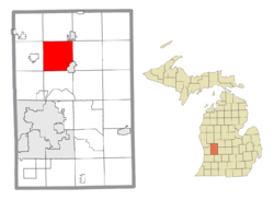
Location within Kent County
|
|
| Country | United States |
| State | Michigan |
| County | Kent |
| Established | 1849 |
| Area | |
| • Total | 34.93 sq mi (90.47 km2) |
| • Land | 34.13 sq mi (88.40 km2) |
| • Water | 0.80 sq mi (2.07 km2) |
| Elevation | 764 ft (233 m) |
| Population
(2020)
|
|
| • Total | 12,055 |
| • Density | 345.12/sq mi (133.249/km2) |
| Time zone | UTC-5 (Eastern (EST)) |
| • Summer (DST) | UTC-4 (EDT) |
| ZIP code(s) | |
| Area code(s) | 616 |
| FIPS code | 26-081-01160 |
| GNIS feature ID | 1625817 |
Algoma Township is a community located in Kent County, in the state of Michigan, United States. It's a place where many people live and work. In 2020, about 12,055 people called Algoma Township home. This was a big jump from 9,932 people in 2010! The township is part of the larger Grand Rapids metropolitan area, which means it's close to the city of Grand Rapids – about 10 miles (16 km) north.
Contents
A Look Back: Algoma's History
Algoma Township began as a settlement in 1843. It officially became a township in 1849.
Early Communities and Mills
In 1856, a man named C. C. Comstock started a mill in the township. A small community called Gougeburg grew up around this mill.
Other small villages also existed. Burchville was set up in 1868 and had its own post office for a while. Edgerton was another village established in 1869. It also had a post office until 1937.
Algoma's Geography: Land and Water
Algoma Township covers an area of about 34.93 square miles (90.47 square kilometers). Most of this area, 34.13 square miles (88.40 square kilometers), is land. The rest, about 0.80 square miles (2.07 square kilometers), is water.
Nature and Rivers
A fun place to visit, the White Pine Trail State Park, runs through the eastern part of the township. The Rogue River also flows through the southern area. These natural features add to the beauty of Algoma Township.
Main Roads in Algoma
Two important highways pass through Algoma Township:
- US 131 goes from south to north through the eastern side.
- M-57 (also known as NE 14 Mile Road) briefly enters the eastern edge and ends at US 131.
Learning in Algoma: School Districts
Students in Algoma Township attend schools in three different public school districts:
- The northwestern part of the township is served by Sparta Area Schools.
- The southeastern part is served by Rockford Public Schools.
- A smaller northeastern section is part of Cedar Springs Public Schools.
Who Lives in Algoma?
In 2000, there were 7,596 people living in Algoma Township. There were 2,588 households, which are groups of people living together. Most of these were families.
Community Life
About 42.3% of households had children under 18 living with them. Many households were married couples. The average household had about 2.94 people.
Age Groups
The population in Algoma Township includes people of all ages. About 30.2% of the people were under 18 years old. About 7.4% were 65 years or older. The average age was 35 years old.
See also
 In Spanish: Municipio de Algoma para niños
 | Bayard Rustin |
 | Jeannette Carter |
 | Jeremiah A. Brown |


