
Alhucemas Islands facts for kids

Map of the Ahucemas Islands
|
|
| Geography | |
|---|---|
| Location | Strait of Gibraltar |
| Coordinates | 35°12′54″N 3°53′46″W / 35.215°N 3.896°W |
| Total islands | 3 |
| Administration | |


The Alhucemas Islands (Spanish: Islas Alhucemas) are a small group of islands. They belong to Spain and are located very close to the coast of Morocco. You can find them in the Alboran Sea, which is part of the Mediterranean Sea. These islands are known as plazas de soberanía, which means "places of sovereignty." They are special Spanish territories in North Africa.
Contents
What are the Alhucemas Islands?
The Alhucemas Islands are made up of three main parts. These are Peñón de Alhucemas, Isla de Mar, and Isla de Tierra. They are located about 300 meters (less than a quarter mile) from the Moroccan town of Al Hoceima. This town used to be called Alhucemas. The islands are also about 146 kilometers (90 miles) east of Ceuta and 84 kilometers (52 miles) west of Melilla. All three islands together cover a total area of about 4.6 hectares (about 11 acres).
Peñón de Alhucemas: The Main Island
Peñón de Alhucemas means "Lavender Rock." It is a tiny rock island. It measures about 220 meters (720 feet) from east to west. It is up to 84 meters (275 feet) from north to south. Its area is about 1.5 hectares (3.7 acres). The highest point is about 27 meters (88 feet) tall. This rock is completely covered by a fort, several houses, and a church. It is one of many "rock-fortresses" found off the coast of North Africa.
Isla de Tierra: The Land Island
Isla de Tierra means "Island of Land." This island is a steep, rocky platform. It is about 11 meters (36 feet) high. It sits about 114 meters (374 feet) north of the Moroccan beach. The island is about 192 meters (630 feet) long from northeast to southwest. It is up to 87 meters (285 feet) wide. Its area is about 1.7 hectares (4.2 acres).
Isla de Mar: The Sea Island
Isla de Mar means "Island of Sea." This islet is flat and about 4 meters (13 feet) high. Its western end is about 93 meters (305 feet) north of Isla de Tierra. It is about 245 meters (804 feet) long from east to west. It is up to 70 meters (230 feet) wide. Its area is about 1.4 hectares (3.5 acres).
History of the Islands
Spanish rule over these islands began in 1559. At that time, the Saadi dynasty gave some territories to Spain. This was in exchange for Spain's help against the Ottoman Empire's armies. In 1673, Spain sent soldiers to Peñón de Alhucemas. Spain has kept control of the island ever since.
The islands are also close to where Spanish and French forces landed in 1925. This happened during the Rif War. Since Morocco became independent in 1956, it has said that these islands should belong to Morocco.
Life on the Islands Today
In 2012, about 25 to 30 soldiers lived in the fort on Peñón de Alhucemas. They were part of the Spanish military. There were also people from the marine services. They used an inflatable boat to get supplies from ships.
Sometimes, people try to cross from Morocco to Isla de Tierra. They hope to reach mainland Spain. In 2012, some immigrants arrived on Isla de Tierra. Spanish troops helped them with medical needs. Then, they were returned to Morocco. The Spanish Army now has a small camp on Isla de Tierra. This helps prevent new attempts to cross illegally.
See also
 In Spanish: Islas Alhucemas para niños
- Plazas de soberanía
- List of Spanish colonial wars in Morocco
- Spanish Protectorate of Morocco
Images for kids
-
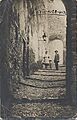
Spanish family on a street of the peñón around 1915

