
Ceuta facts for kids
Quick facts for kids
Ceuta
سَبْتَة
|
|||
|---|---|---|---|
|
|
|||
|
|||
| Anthem: Ceuta, mi ciudad querida "Ceuta, my beloved city" |
|||

Location of Ceuta in Spain
|
|||
| Country | |||
| First settled | 1st millennium BC | ||
| End of Muslim rule | 14 August 1415 | ||
| Ceded to Spain/Iberian Union | 4 August 1578 | ||
| Autonomy status | 14 March 1995 | ||
| Founded by | Carthaginians | ||
| Government | |||
| • Type | Autonomous city | ||
| • Body | Council of Government | ||
| Area | |||
| • Total | 18.5 km2 (7.1 sq mi) | ||
| • Land | 18.5 km2 (7.1 sq mi) | ||
| Area rank | 18th | ||
| Elevation | 10 m (30 ft) | ||
| Highest elevation | 349 m (1,145 ft) | ||
| Population
(2018)
|
|||
| • Total | 85,144 | ||
| • Rank | 19th | ||
| • Density | 4,602/km2 (11,920/sq mi) | ||
| • Density rank | 2nd | ||
| Demonyms | Ceutan ceutí (es) caballa ("Atlantic mackerel", colloquial) |
||
| GDP | |||
| • Total | €1.907 billion (2022) | ||
| • Per capita | €23,073 (2022) | ||
| Time zone | UTC+01:00 (CET) | ||
| • Summer (DST) | UTC+02:00 (CEST) | ||
| ISO 3166 code |
ES-CE
|
||
| Postal code |
51001–51005
|
||
| Official language | Spanish | ||
| Parliament | Assembly of Ceuta | ||
| Congress | 1 deputy (out of 350) | ||
| Senate | 2 senators (out of 264) | ||
| Currency | Euro (€) (EUR) | ||

.jpg)


Ceuta is an autonomous city of Spain. It's located on the North African coast, right next to Morocco. This city is very important because it sits at the entrance to the Mediterranean Sea from the Atlantic Ocean.
Ceuta is one of Spain's special territories in Africa, like Melilla and the Canary Islands. Before Spain joined the European Union, Ceuta was a free port, meaning goods could be traded without many taxes. Today, its population is mostly Christian and Muslim. There are also smaller groups of Sephardic Jews and Sindhi Hindus.
Spanish is the official language. However, many people also speak Darija Arabic.
Contents
Understanding Ceuta's Name
The name Ceuta comes from a very old history. The area was once called Abyla, which might have meant "Lofty Mountain" or "Mountain of God". This name was used for Jebel Musa, a mountain nearby.
Later, the settlement was named after the seven hills around it. These hills were known as the "Seven Brothers" (Septem Fratres in Latin). Over time, this long name was shortened to Septem, then Septa. These shorter names eventually became Sebta in Berber and Arabic, and finally Ceuta in Portuguese and Spanish.
Ceuta's Long History
Ceuta has a very long and interesting history. Its location at the Strait of Gibraltar made it a key spot for trade and military control.
Ancient Times: A Strategic Port
.jpg)
Around 1,000 BC, the Phoenicians realized Ceuta's location was perfect for defense. They built an outpost there because the narrow strip of land connecting it to Africa made it easy to protect. The ancient Greeks called it Abyla.
After the Punic Wars, the Romans took control. They called the settlement "Septem". By the 1st century AD, it became a Roman colony. Ceuta grew rich by trading with Roman Spain, especially known for its salted fish. It had roads connecting it to other important cities. By the late 300s AD, about 10,000 people lived there, mostly Christians speaking a local Latin language.
Medieval Era: Changing Hands


In the 5th century, the Vandals took over North Africa, including Ceuta. Later, around 533 AD, the Byzantine Empire (Eastern Roman Empire) conquered it. Ceuta became their westernmost outpost.
Around 710 AD, the Islamic conquest of the Maghreb began. Ceuta came under Muslim rule and was called Sebta. It was later destroyed during a Berber revolt around 740. After this, it remained a small village until it was rebuilt in the 9th century.
Over the next centuries, Ceuta was ruled by different North African groups. These included the Almoravids (from 1084) and then the Almohads (from 1147). After a period of instability, the city was finally conquered by the Fez in 1387.
Portuguese Rule: A New Era

_ca_1572.jpg)

On August 21, 1415, King John I of Portugal led a surprise attack on Ceuta. His army of 45,000 men captured the city easily. This event is known as the Conquest of Ceuta.
King John's son, Henry the Navigator, became famous during this battle. The city's flag today is similar to Lisbon's flag, but with the Portuguese coat of arms in the center.
Ceuta became an important Portuguese outpost. However, it was expensive to maintain. In 1437, Henry the Navigator tried to capture Tangier to make Ceuta more valuable, but this failed. Despite this, Ceuta's position led to further Portuguese expansion along the North African coast.
The city's status as a Portuguese possession was confirmed by treaties in 1479 and 1494. In the 1540s, the Portuguese began building the strong Royal Walls of Ceuta that you can still see today.
Iberian Union and Spanish Control
In 1580, the crowns of Portugal and Spain were united under Philip II of Spain. This period is called the Iberian Union. During this time, many Spanish settlers moved to Ceuta.
When Portugal regained its independence in 1640, Ceuta chose to remain with Spain. On January 1, 1668, Portugal officially gave Ceuta to King Carlos II of Spain through the Treaty of Lisbon.


Ceuta faced a very long siege by Moroccan forces from 1694 to 1727. During the Napoleonic Wars, Britain occupied Ceuta from 1810 to 1815. Later, a border dispute led to the Hispano-Moroccan War (1859–60).
In July 1936, Francisco Franco led a military uprising that started the Spanish Civil War. Ceuta was one of the first places seized by Franco's forces.
When Spanish Morocco gained independence in 1956, Ceuta remained part of Spain. Spain considers Ceuta an integral part of its country. Today, Ceuta is a diverse city with a mix of cultures and religions. In 2007, King Juan Carlos I visited Ceuta, which was the first visit by a Spanish head of state in 80 years. Since 2010, Ceuta celebrates the Muslim holiday of Eid al-Adha as an official public holiday.
Ceuta's Geography


Ceuta is located on a small peninsula in North Africa. It is only about 17 kilometers (11 miles) away from mainland Spain across the Strait of Gibraltar. It shares a 6.4-kilometer (4-mile) land border with Morocco.
The city is dominated by Monte Anyera, a hill on its western side. Monte Hacho, on the Peninsula of Almina, is thought to be one of the ancient Pillars of Hercules.
Important Bird Area
The Ceuta Peninsula is a very important place for birds. It's recognized as an Important Bird Area (IBA) because many birds, especially raptors and storks, fly over it when migrating between Europe and Africa. This makes it a "choke point" where you can see many different species.
Climate
Ceuta has a Mediterranean climate. This means it has mild winters and warm, dry summers. The average yearly temperature is about 18.8°C (65.8°F). Summers are dry, but the city still gets a good amount of rain each year.
| Climate data for Ceuta, 2003-2010 | |||||||||||||
|---|---|---|---|---|---|---|---|---|---|---|---|---|---|
| Month | Jan | Feb | Mar | Apr | May | Jun | Jul | Aug | Sep | Oct | Nov | Dec | Year |
| Record high °C (°F) | 21.7 (71.1) |
25.5 (77.9) |
27.9 (82.2) |
28.4 (83.1) |
33.7 (92.7) |
35.3 (95.5) |
40.2 (104.4) |
38.9 (102.0) |
34.8 (94.6) |
33.1 (91.6) |
27.2 (81.0) |
25.6 (78.1) |
40.2 (104.4) |
| Mean daily maximum °C (°F) | 15.8 (60.4) |
15.9 (60.6) |
17.4 (63.3) |
19.1 (66.4) |
21.9 (71.4) |
25.7 (78.3) |
28.9 (84.0) |
28.5 (83.3) |
25.8 (78.4) |
22.8 (73.0) |
18.8 (65.8) |
16.4 (61.5) |
21.4 (70.5) |
| Daily mean °C (°F) | 13.4 (56.1) |
13.7 (56.7) |
14.8 (58.6) |
16.4 (61.5) |
18.8 (65.8) |
22.3 (72.1) |
24.9 (76.8) |
25.0 (77.0) |
22.8 (73.0) |
20.2 (68.4) |
16.4 (61.5) |
14.3 (57.7) |
18.6 (65.4) |
| Mean daily minimum °C (°F) | 11.0 (51.8) |
11.4 (52.5) |
12.2 (54.0) |
13.6 (56.5) |
15.7 (60.3) |
18.8 (65.8) |
20.9 (69.6) |
21.5 (70.7) |
19.8 (67.6) |
17.5 (63.5) |
14.0 (57.2) |
12.1 (53.8) |
15.7 (60.3) |
| Record low °C (°F) | 1.3 (34.3) |
4.4 (39.9) |
7.2 (45.0) |
9.0 (48.2) |
10.5 (50.9) |
7.2 (45.0) |
16.3 (61.3) |
18.0 (64.4) |
15.3 (59.5) |
12.2 (54.0) |
7.4 (45.3) |
6.3 (43.3) |
1.3 (34.3) |
| Average precipitation mm (inches) | 122 (4.8) |
145 (5.7) |
90 (3.5) |
57 (2.2) |
21 (0.8) |
3 (0.1) |
1 (0.0) |
3 (0.1) |
37 (1.5) |
82 (3.2) |
127 (5.0) |
161 (6.3) |
849 (33.2) |
| Average precipitation days (≥ 1 mm) | 8 | 9 | 6 | 6 | 4 | 1 | 0 | 0 | 2 | 7 | 7 | 10 | 60 |
| Average relative humidity (%) | 72 | 75 | 68 | 71 | 66 | 67 | 61 | 70 | 72 | 75 | 73 | 73 | 70 |
| Source: Agencia Estatal de Meteorología | |||||||||||||
Defense and Security
The Spanish Armed Forces are in charge of defending Ceuta. The Spanish Army has different units stationed there, including infantry, cavalry, and artillery. They use modern tanks and anti-aircraft guns.
The Civil Guard is responsible for border security. They protect the land border and the sea approaches. This is important because many migrants try to cross into Ceuta to reach Europe.
Ceuta's Economy

The official money in Ceuta is the euro. Ceuta is a special low-tax zone in Spain. Its economy relies a lot on its port, which is currently expanding. It also has busy industrial and retail centers.
Big stores like Lidl and Decathlon have branches in Ceuta. There is also a casino. Trade between Ceuta and Morocco is very active because of the tax-free status. Many Moroccan women work as porteadoras, carrying goods across the border. The Moroccan dirham is often used in this trade, even though prices are in euros.
Transport
The Port of Ceuta is very busy. Many ferries arrive each day from Algeciras in southern Spain. The closest airport is in Morocco.
There is one main road border checkpoint to Morocco, allowing cars and people to cross. Another crossing for pedestrians is between Benzú and Belyounech. A bus service operates throughout Ceuta, connecting to the border crossings.
Hospitals
Ceuta has several hospitals and medical centers:
- University Hospital of Ceuta (established 2010)
- Primary Care Emergency Services Jose Lafont
- Ceuta Medical Centre
- Spanish Military Hospital
People and Culture in Ceuta

As of 2018, Ceuta had a population of 85,144 people. Because of its location, Ceuta has a mix of different ethnic and religious groups. The two largest groups are Christians and Muslims. About 50% of the population is Christian and 48% is Muslim.
Spanish is the main and official language. However, Moroccan Arabic (Darija) is also widely spoken.
Religion in Ceuta


Christianity has been present in Ceuta for a very long time. There are ruins of an ancient Christian church in the city center. The main mosque was built over a Byzantine church, and after the Portuguese conquest in 1415, it became the Ceuta Cathedral. The cathedral was finished in 1726.
There are also smaller Jewish and Hindu communities in Ceuta.
| Roman Catholicism |
60.0%
|
| Islam |
36.7%
|
| Non-religious |
1.9%
|
| Atheist |
1.5%
|
Migration to Ceuta
Like Melilla, Ceuta attracts migrants from Africa who hope to enter Europe. The city is surrounded by tall fences, and many migrants gather near them, hoping to cross and seek asylum.
Education in Ceuta
The University of Granada has a campus in Ceuta, offering university programs. The National University of Distance Education (UNED) also serves students in Ceuta.
While most schools teach in Spanish, more and more schools are starting bilingual education programs.
Famous People from Ceuta
Many notable people have come from Ceuta:
- Qadi Ayyad (1083–1149) – a great Islamic scholar.
- Muhammad al-Idrisi (1100–1165) – a famous Muslim geographer and mapmaker.
- Joseph ben Judah of Ceuta (c. 1160–1226) – a Jewish doctor and poet.
- Francisco Llano de la Encomienda (1879–1963) – a Spanish soldier who stayed loyal to the government during the Spanish Civil War.
- África de las Heras Gavilán (1909–1988) – a Spanish Communist and Soviet spy.
- Eugenio Martín (born 1925) – a Spanish film director.
- Juan Jesús Vivas Lara (born 1953) – the current Mayor-President of Ceuta.
- Miguel Bernardo Bianquetti (born 1951) – a famous Spanish footballer who played for FC Barcelona.
- Nayim (born 1966) – a Spanish footballer known for scoring a famous goal in a European cup final.
- Lorena Miranda (born 1991) – a Spanish water polo player who won a silver medal at the 2012 Summer Olympics.
Sister Cities
Ceuta is twinned with several cities around the world, meaning they have special friendly relationships:
- Aci Catena, Italy
- Algeciras, Spain
- Buenos Aires, Argentina
- Cádiz, Spain
- Melilla, Spain
- Santarém, Portugal
Dispute with Morocco
Morocco believes that Ceuta, Melilla, and other Spanish territories in North Africa should belong to Morocco. They argue that because Ceuta is surrounded by Moroccan land, it should be part of Morocco.
However, Spain disagrees. The Spanish government says that Ceuta has been a part of Spain since the 16th century, long before Morocco became an independent country in 1956. Most people living in Ceuta want to remain part of Spain.
When Spain joined NATO (a military alliance), Ceuta was not automatically covered by its defense agreement. However, NATO leaders have stated that they are there to protect all allies. In 2020, after a Moroccan official said Ceuta was "Moroccan," Spain called in the Moroccan ambassador to state that Spain expects its territory to be respected.
See also
 In Spanish: Ceuta para niños
Images for kids
-
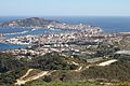
View of Ceuta
-
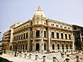
Palace of the Assembly
